Sortieren nach:
- Kategorie
- Liste
- Galerie
Ein Abonnement der Preisliste ist notwendig um Ergebnisse, von Auktionen die vor einem längeren Zeitraum als 10 Tagen stattgefunden haben, ansehen zu können. Klicken Sie hier für mehr Informationen
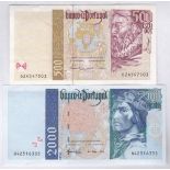

Portugal 1992/7 2000 Escudos, P189c; 500 Escudos, P187d, EF (2)
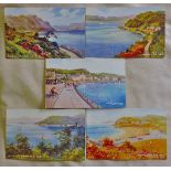
Scotland -Oban fine colour views, valentines
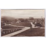
Bainesbridge(Yorks)-village view, Friths, 1930's
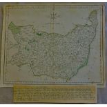
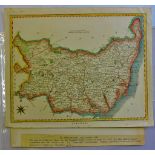
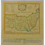
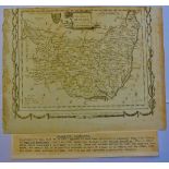
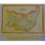
Suffolk 1787-A map of Suffolk by John Cary, from the 'New and Correct Atlas' (26cmx22cm) very fine.
Suffolk 1787-A map of Suffolk by John Cary, from the 'New and Correct Atlas' (26cmx22cm) very fine.
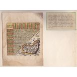
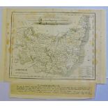
Antique Maps - 1828 Map from 'Encyclopaedia Londinensis' with many misspellings e.g. Hawkstead/
Antique Maps - 1828 Map from 'Encyclopaedia Londinensis' with many misspellings e.g. Hawkstead/Harkstead, Nedham/Needham, Eastrohoel/East Bergholt...
Antique Maps-1635-(1643 Edition) "Directions for English Travellor" by Thomas Jennes, includes a
Antique Maps-1635-(1643 Edition) "Directions for English Travellor" by Thomas Jennes, includes a table of distance,10x10cm, very fine, some water ...
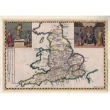
Antique Maps - England, Hermannides,1661 Map and Cartouches 'Britannia Saxonica' from Britannia
Antique Maps - England, Hermannides,1661 Map and Cartouches 'Britannia Saxonica' from Britannia Magna(Amsterdam) engraved by M Burghers. A rare co...
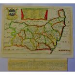
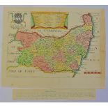
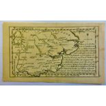
Antique Maps - Suffolk Blome, R1693 Map from ' Cosmography' decorative, dedicated to Charles, Lord
Antique Maps - Suffolk Blome, R1693 Map from ' Cosmography' decorative, dedicated to Charles, Lord Cornwallis, |Baron of Eyr (Arm Inset) Hundred o...
Antique Maps - Suffolk,Taylor-Blome,1715 map from 'England Exactly Described' decorative with Lord
Antique Maps - Suffolk,Taylor-Blome,1715 map from 'England Exactly Described' decorative with Lord Cornwallis Arms and Hundreds in Suffolk inset.2...
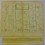
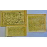
Antique Maps - 1719 Road Maps 'Ipswich to Norwich & Cromer' from Principle Roads of England and
Antique Maps - 1719 Road Maps 'Ipswich to Norwich & Cromer' from Principle Roads of England and Wales' Reduced from Ogilby, 22cm x 18cm, uncoloure...
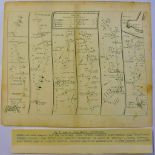
Antique Maps - 1719 Road Map - Kings Lynn to Harwich from 'Principle Roads of England and Wales'
Antique Maps - 1719 Road Map - Kings Lynn to Harwich from 'Principle Roads of England and Wales' reduced from Ogiby, 22cm x 15cm uncoloured, edge ...
Antique Maps-1742 Edition 'Chordgraphica Britannia' by W.H.Toms - 18th Century mail routes showing
Antique Maps-1742 Edition 'Chordgraphica Britannia' by W.H.Toms - 18th Century mail routes showing recipients address and directions given by the ...
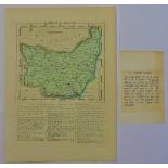
Antique Maps - 1759 Map from 'General magazines of Arts and Science/The Natural History of England, Hundreds inset, Burugh Towns, Market Towns and...
Antique Maps - 1764 map from 'England Illustrated'26mm x 19mm, very fine.
Antique Maps - 1769 map from 'England Displayed'(Previously small British Atlas)20cmx16cm, very
Antique Maps - 1769 map from 'England Displayed'(Previously small British Atlas)20cmx16cm, very fine.
Antique Maps - 1966 Map from Elliss English Atlas(copied from Kitchins map of 1764)25cmx19cm, very
Antique Maps - 1966 Map from Elliss English Atlas(copied from Kitchins map of 1764)25cmx19cm, very fine.
Antique Maps - 1769 map from New British Traveller(1784)embellished surrounds, published by Alexander Hogg, 21cmx16cm, very fine, some page edge t...
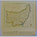
Antique Maps - 1787 Map from English Atlas or Concise View of England and Wales, 13cmx12cm, very
Antique Maps - 1787 Map from English Atlas or Concise View of England and Wales, 13cmx12cm, very fine(page 37)
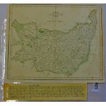
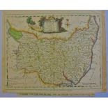
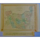
Antique Maps - 1807 Map from 'Universal Magazine' the Laurie and Whittles New and Improved Atlas
Antique Maps - 1807 Map from 'Universal Magazine' the Laurie and Whittles New and Improved Atlas 24cmx18cm very fine, some edge paper toned.
Antique Maps - 1810 Map from Wallis 'New Edition of the English Counties' miniature, 12cmx14cm,
Antique Maps - 1810 Map from Wallis 'New Edition of the English Counties' miniature, 12cmx14cm,very fine, with excessive misspelling for the perio...
Antique Maps - 1812 map from 'New and Improved County Atlas, 26x18mm, very fine, hundreds listed
Antique Maps - 1812 map from 'New and Improved County Atlas, 26x18mm, very fine, hundreds listed inset.
Antique Maps - 1818 Map from 'Excursions through Suffolk' very fine, folding crease.
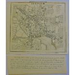
Antique Maps - 1817 Map Ipswich Town, from Excursions in Suffolk' folding crease, very fine.
Antique Maps - 1817 Map Ipswich Town, from Excursions in Suffolk' folding crease, very fine.
Antique Maps - 1834 Map from the 'New British Atlas' very fine. 24cmx19cm.
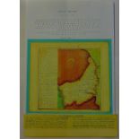
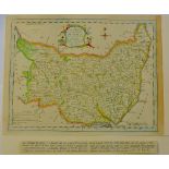
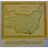
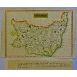
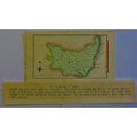
Antique Maps - 1846 Map from 'parliamentary Gazetteer of England and Wales'24cmx19cm, very fine,
Antique Maps - 1846 Map from 'parliamentary Gazetteer of England and Wales'24cmx19cm, very fine, some toning.
Antique Maps - 1830 Small maps from S.Leighs 'New Atlas of England and Wales,12cmx19cm.
Antique Maps - 1759 Miniature map from 'New and Accurate Maps of Countries of England and Wales',
Antique Maps - 1759 Miniature map from 'New and Accurate Maps of Countries of England and Wales',12cmx8cm,very fine, scarce.
Antigua Maps - 1759 Miniature Map from 'New and Accurate Maps of Countries of England and Wales'12cm
Antigua Maps - 1759 Miniature Map from 'New and Accurate Maps of Countries of England and Wales'12cm x 8 cm, very fine, scarce.