
Sortieren nach:
- Kategorie
- Liste
- Galerie
Ein Abonnement der Preisliste ist notwendig um Ergebnisse, von Auktionen die vor einem längeren Zeitraum als 10 Tagen stattgefunden haben, ansehen zu können. Klicken Sie hier für mehr Informationen
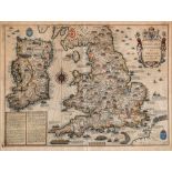

JOHN SPEED (1552-1629), "The Invasions of England and Ireland with all their Civill Wars since the
JOHN SPEED (1552-1629), "The Invasions of England and Ireland with all their Civill Wars since the Conquest", published by George Humble c.1627, h...
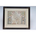
JOHN SPEED (1552-1629), "Buckingham Shyre & Shire Town Describ", hand coloured map with title
JOHN SPEED (1552-1629), "Buckingham Shyre & Shire Town Describ", hand coloured map with title cartouche, Thomas Bassett and Rip Chiswell, c.1666, ...
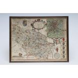
JOHN SPEED (1552-1629), The West Riding of Yorkshire, hand coloured engraved map Sudbury & Humble
JOHN SPEED (1552-1629), The West Riding of Yorkshire, hand coloured engraved map Sudbury & Humble 1610, with title cartouche, plan of York, figura...
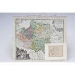
TOBIAS MAYER (1723-1762), "Mappa Geographica Regni Polonias", hand coloured engraved map with
TOBIAS MAYER (1723-1762), "Mappa Geographica Regni Polonias", hand coloured engraved map with title cartouche and coats of arms, Hevitiers de Homa...
TEESDALE'S MAP OF YORKSHIRE, Henry Teesdale & Co. and C. Stocking 1817 and corrected in 1827 and
TEESDALE'S MAP OF YORKSHIRE, Henry Teesdale & Co. and C. Stocking 1817 and corrected in 1827 and 1828, hand coloured engraved large scale map with...
TEESDALE'S MAP OF LANCASHIRE, A Map of the County Palantine of Lancaster, Divided into Hundreds
TEESDALE'S MAP OF LANCASHIRE, A Map of the County Palantine of Lancaster, Divided into Hundreds and Parishes, 1828-1829, by G. Hennet, published b...
AROUND HALIFAX, reduced Ordnance Survey folding cloth map by G.G. Richmond, together with another,
AROUND HALIFAX, reduced Ordnance Survey folding cloth map by G.G. Richmond, together with another, Yorkshire Coalfield, Bacons New Chart of The Wo...