Verfeinern Sie Ihre Suche
Sortieren nach:
- Auktionshaus-Kategorie
- Liste
- Galerie
Ein Abonnement der Preisliste ist notwendig um Ergebnisse, von Auktionen die vor einem längeren Zeitraum als 10 Tagen stattgefunden haben, ansehen zu können. Klicken Sie hier für mehr Informationen
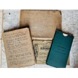

Collection of 19th- & 20th-century OS maps and similar, approximately 50, to include a map of
Collection of 19th- & 20th-century OS maps and similar, approximately 50, to include a map of Birmingham, 1876, with tramways marked and a manuscr...
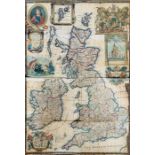
British Isles. Willdey, George. Map of Great Britain and Ireland, 1715. Hand-coloured copper
British Isles. Willdey, George. Map of Great Britain and Ireland, 1715. Hand-coloured copper engraving on laid/chain-lined paper, featuring inset ...
![Moll, Herman. Atlas Minor, London: Thomas & John Bowles, [1736 or later]. Quarto, 58 [of 62] hand-](https://portal-images.azureedge.net/auctions-2021/hanson10391/images/45ed7433-c59c-4ae7-b435-adff00e64338.jpg?w=155&h=155)
Moll, Herman. Atlas Minor, London: Thomas & John Bowles, [1736 or later]. Quarto, 58 [of 62] hand-
Moll, Herman. Atlas Minor, London: Thomas & John Bowles, [1736 or later]. Quarto, 58 [of 62] hand-coloured, copper-engraved maps on laid/chain-lin...
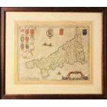
Joan Blaeu (1596-1673). Map of Cornwall, c.1645, hand-coloured copper engraving on laid/chain-
Joan Blaeu (1596-1673). Map of Cornwall, c.1645, hand-coloured copper engraving on laid/chain-lined paper, featuring armorial shields and ships. 4...
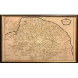
Robert Morden (1650-1703). Map of Norfolk, hand-coloured copper engraving on laid/chain-lined paper,
Robert Morden (1650-1703). Map of Norfolk, hand-coloured copper engraving on laid/chain-lined paper, 38cm by 62cm, framed & glazed. Appears well-p...
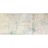
London & Middlesex. Sectional map, linen-backed, hand-coloured outline, Letts & Son, based on
London & Middlesex. Sectional map, linen-backed, hand-coloured outline, Letts & Son, based on Ordnance Survey by Colonel Colby, 12 July 1844. 56" ...
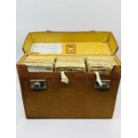
Great Britain. Cased set of 23 sectional, linen-backed road maps, 1933, with RAC route itinerary
Great Britain. Cased set of 23 sectional, linen-backed road maps, 1933, with RAC route itinerary of a journey from Walsall to Dover with street ma...
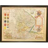
John Speed (1552-1629). Map of Lincolnshire, c.1676, hand-coloured copper engraving on laid/chain-
John Speed (1552-1629). Map of Lincolnshire, c.1676, hand-coloured copper engraving on laid/chain-lined paper, featuring armorial shields, sea mon...
Schenk & Valk. Map of Leicestershire, c.1715, hand-coloured copper engraving on laid/chain-lined
Schenk & Valk. Map of Leicestershire, c.1715, hand-coloured copper engraving on laid/chain-lined paper, featuring armorial shields and figures, 53...
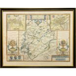
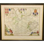
John Speed (1552-1629). Map of Rutland, c.1676, hand-coloured copper engraving on laid/chain-lined
John Speed (1552-1629). Map of Rutland, c.1676, hand-coloured copper engraving on laid/chain-lined paper, featuring inset views of Oakham and Stam...
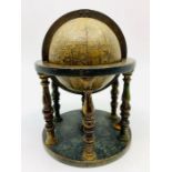
A 16th-century terrestrial globe by, or a derivative of, Francois Demongenet (active 1550-60). 12
A 16th-century terrestrial globe by, or a derivative of, Francois Demongenet (active 1550-60). 12 engraved gores; stippled effect to the seas with...