Sortieren nach:
- Auktionshaus-Kategorie,
- Kategorie
- Liste
- Galerie
Ein Abonnement der Preisliste ist notwendig um Ergebnisse, von Auktionen die vor einem längeren Zeitraum als 10 Tagen stattgefunden haben, ansehen zu können. Klicken Sie hier für mehr Informationen

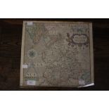
Framed and glazed map of Derbyshire.
Framed and glazed map of Derbyshire. Engraved by William Hole 1637 from the map by Christopher Saxton 1579. Hand tinted. 37cm x 34cm.
Saxton and Hole, A Map of Derbyshire, hand tinted, probably early 18th Century, 32cm high, 40cm wide, unframed
Saxton and Hole, A Map of Cheshire, hand tinted, probably early 18th Century, 27cm high, 31cm wide,
Saxton and Hole, A Map of Cheshire, hand tinted, probably early 18th Century, 27cm high, 31cm wide, unframed
Saxton and Hole, A Map of Lancastriae, hand tinted, probably early 18th Century, 31cm high,
Saxton and Hole, A Map of Lancastriae, hand tinted, probably early 18th Century, 31cm high, 34cm wide, unframed
Eman Bowen, 'An Accurate Map of the County Palatine of Chester', from the Royal Atlas, rarer edition. 18th Century, hand tinted, 42cm high, 51cm...
Eman Bowen, 'An Accurate Map of Warwickshire, Drawn from the best Surveys & Intelligence, Divided into the Hundreds', dated 1777, taken from the R...
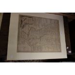
Tho Kitchen, 'A New and Accurate Map of Warwickshire, Drawn from the best Surveys and Intelligence,
Tho Kitchen, 'A New and Accurate Map of Warwickshire, Drawn from the best Surveys and Intelligence, Divided into its Hundreds', inset with etching...
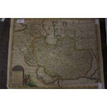
Eman Bowen, 'A New and Accurate Map of Persia', hand tinted, 36cm high, 45cm wide, unframed
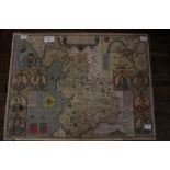
John Speed, A map entitled 'The Countie Pallatine of Lancaster Described and Divided in Hundreds',
John Speed, A map entitled 'The Countie Pallatine of Lancaster Described and Divided in Hundreds', dated 1610, bearing portraits of previous Monar...
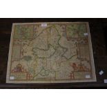
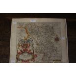
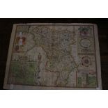
John Speed, 'Stafford, Countie and Towne with the ancient Citie Lichfield described', inset with a maps of the centre of Stafford and Lichfield, h...
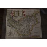
John Speed, 'The Countie of Nottingham described, The Shire Townes Situation and the Earls there of observed', showing the town of Nottingham to u...
Eman Bowen, 'An Accurate Map of the Counties of Leicester and Rutland, Divided into their respective Hundreds', bearing a cartouche inscribed 'To ...
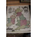
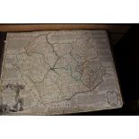
Seutter, A Map of the British Isles, hand coloured, inscribed in Latin, probably 18th Century,
Seutter, A Map of the British Isles, hand coloured, inscribed in Latin, probably 18th Century, 62cm high, 52cm wide
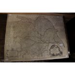
Robert Morden, a Map of Warwickshire, showing parts of other surrounding counties, published in the 'Camden Brittania' 1695 to 1722, hand tinted, ...
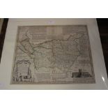
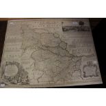
Emanuel Bowen, 'An Improved Map of the County of Stafford, Divided into its Hundreds', circa 1850,
Emanuel Bowen, 'An Improved Map of the County of Stafford, Divided into its Hundreds', circa 1850, bearing a coloured cartouche 'To the Noble and ...
Eman Bowen, 'An Accurate Map of the County of Derby, Divided into its Hundreds and Drawn from the best Authorities, hand tinted, 18th Century, unf...
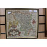
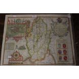
John Speede, a county map of 'Darbieshire' dated 1666, hand tinted and bearing the arms of all those honorable famylyes, as have bourne the dignit...
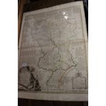
Eman Bowen, 'An Accurate Map of the County of York, Divided into its Ridings and Subdivided into Wapontakes, from the Royal Atlas, showing parts o...
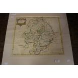
Eman Bowen, 'An Accurate Map of Derbyshire, Divided into its Hundreds', from the Royal Atlas,
Eman Bowen, 'An Accurate Map of Derbyshire, Divided into its Hundreds', from the Royal Atlas, showing parts of surrounding counties, hand tinted, ...
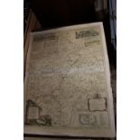
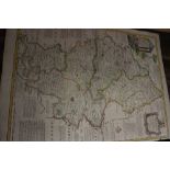
Eman Bowen, 'An Accurate Map of the West Riding of Yorkshire, Divided into its Wapontakes',
Eman Bowen, 'An Accurate Map of the West Riding of Yorkshire, Divided into its Wapontakes', bearing a cartouche entitled 'To the Noble and Most Ho...