Sortieren nach:
- Kategorie
- Liste
- Galerie
Ein Abonnement der Preisliste ist notwendig um Ergebnisse, von Auktionen die vor einem längeren Zeitraum als 10 Tagen stattgefunden haben, ansehen zu können. Klicken Sie hier für mehr Informationen

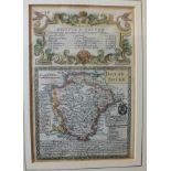
Pierre Montier, 'Carte D'Artois Et Des Environs a L'usage Le Monseigneur Le Duc De Bourgogne'. a
Pierre Montier, 'Carte D'Artois Et Des Environs a L'usage Le Monseigneur Le Duc De Bourgogne'. a hand-coloured map, 50.5 x 60.5cm, together with a...
Emanuel Bowen, A Correct Map of the South East Part of Germany Including the Electorate of Bavaria....., hand-coloured map for Mr Tyndal's continu...
Owen Bowen, The Road from Bristol to Exeter, Devonshire, hand-coloured engraved book plate, another,
Owen Bowen, The Road from Bristol to Exeter, Devonshire, hand-coloured engraved book plate, another, together with three uncoloured examples; T Ki...
Owen Bowen, a collection of six hand-coloured road maps, including Tinmouth to Carlisle, London to
Owen Bowen, a collection of six hand-coloured road maps, including Tinmouth to Carlisle, London to Kings Lynn, Huntingdon to Ipswich, Hereford to ...
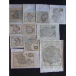
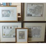
John Seller, five small hand-coloured maps of English counties, 12.5 x 15cm, mainly late-18th
John Seller, five small hand-coloured maps of English counties, 12.5 x 15cm, mainly late-18th century; Emanuel Bowen, Cumberland Divided into Ward...
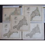
John Carey, Cornwall, hand-coloured map with a vignette of the Scilly Isles, 1787, 23 x 27.5cm,
John Carey, Cornwall, hand-coloured map with a vignette of the Scilly Isles, 1787, 23 x 27.5cm, three others, similar and a later hand-coloured bo...
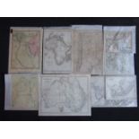
A collection of world atlas maps, mainly 19th century including: Keith Johnston, Australia; C Smith,
A collection of world atlas maps, mainly 19th century including: Keith Johnston, Australia; C Smith, Egypt; S Hall, Asia, Chile, La Plata and Part...
A collection of Rapkin and other 19th century hand-coloured maps of European countries, together
A collection of Rapkin and other 19th century hand-coloured maps of European countries, together with Turkey, the Baltic Sea, The Crimea, (21).
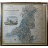
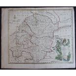
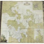
C J J Greenwood & Co, "Map of the South East circuit of the Principality of Wales, Comprising the
C J J Greenwood & Co, "Map of the South East circuit of the Principality of Wales, Comprising the Counties of Glamorgan, Brecon and Radnor from an...
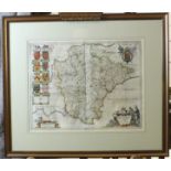
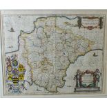
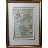
Property of a Collector, now deceased. Blaeu (Johannes) "Devonia Vulgo Devonshire", circa 1645,
Property of a Collector, now deceased. Blaeu (Johannes) "Devonia Vulgo Devonshire", circa 1645, hand-coloured map, 39 x 50cm, double-sided. ...[m...
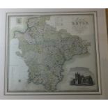
Bowen (Emanuel), "An Accurate Map of Devonshire, Divided into its Hundreds", Bowles & Sayers, hand-
Bowen (Emanuel), "An Accurate Map of Devonshire, Divided into its Hundreds", Bowles & Sayers, hand-coloured map with vignette and plan of Plymouth...
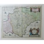
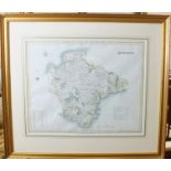
Morden (Robert), "Devonshire", hand-coloured map, 1695, 36 x 41.4cm.
Jansson (Jan), "Devonia Descriptio, The Description of Devonshire", 1644 or later, hand-coloured
Jansson (Jan), "Devonia Descriptio, The Description of Devonshire", 1644 or later, hand-coloured map, 40 x 51cm, pub: P Schenk & G Valk. ...[more]
Jansson (Jan), "Devonia Descriptio, The Description of Devonshire", hand-coloured map, 38 x 49cm.
Jansson (Jan), "Devonia Descriptio, The Description of Devonshire", hand-coloured map, 38 x 49cm.
Cary (John), "A Map of Devonshire from the Best Authorities", uncoloured map, 43 x 48cm, undated,
Cary (John), "A Map of Devonshire from the Best Authorities", uncoloured map, 43 x 48cm, undated, 1789(?) and Moll (Herman), Devonshire, hand-colo...
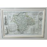
Donn (Benjamin), "A Map of the County of Devon with the City & County of Exeter, Delineated from
Donn (Benjamin), "A Map of the County of Devon with the City & County of Exeter, Delineated from an Actual Survey by Benjamin Donn, engraved by Th...
T L Murray, "Devonshire", hand-coloured map, 36 x 46, Weller (Edward), "Devonshire, South Division",
T L Murray, "Devonshire", hand-coloured map, 36 x 46, Weller (Edward), "Devonshire, South Division", hand-coloured map, 31 x 45cm and three other ...
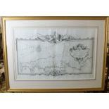
Pine (J), "A Plott of All the Coast of Cornwall and Devonshire as they were to be Fortified in
Pine (J), "A Plott of All the Coast of Cornwall and Devonshire as they were to be Fortified in 1588 against the Landing of any Enemy", uncoloured,...
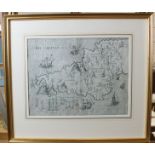
Drayton (Michael), "Devon Shyre, Cornwal", an allegorical engraved map, circa 1612, 25 x 33cm.
Drayton (Michael), "Devon Shyre, Cornwal", an allegorical engraved map, circa 1612, 25 x 33cm.
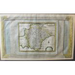
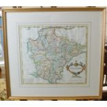
Pierre Vander Aa, "Comté de Devon", hand-coloured map with architectural surround, circa 1729, 25
Pierre Vander Aa, "Comté de Devon", hand-coloured map with architectural surround, circa 1729, 25 x 41cm.
Owen & Bowen, "Map of Devonshire, the Road from Bristol to Exeter", 19.5 x 13.5cm, and 18th century strip road map "Dartmouth to Newton Bushel", 1...
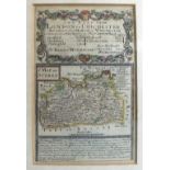
An 18th century double-map, "A Modern Map of Cornwall and Modern Map of Devonshire for Walpoole's
An 18th century double-map, "A Modern Map of Cornwall and Modern Map of Devonshire for Walpoole's New and Complete British Traveller", pub: Alex. ...
Cooper, a hand-coloured bookplate map of Devonshire, 12 x 20cm, James Wallace, a hand-coloured
Cooper, a hand-coloured bookplate map of Devonshire, 12 x 20cm, James Wallace, a hand-coloured bookplate map of Devonshire and three later Moule h...
Ogilby (John), "Roads from Exeter to Dorchester", a hand-coloured strip road map, circa 1675, 33 x
Ogilby (John), "Roads from Exeter to Dorchester", a hand-coloured strip road map, circa 1675, 33 x 46.
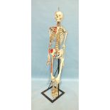
A composite full teaching skeleton, with colouring and notations.