
Sortieren nach:
- Kategorie
4 items
- Liste
- Galerie
Ein Abonnement der Preisliste ist notwendig um Ergebnisse, von Auktionen die vor einem längeren Zeitraum als 10 Tagen stattgefunden haben, ansehen zu können. Klicken Sie hier für mehr Informationen

Los 14
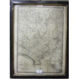
A 19th century map 'The Environs of Plymouth, Stonehouse and Devonport showing the Existing and
A 19th century map 'The Environs of Plymouth, Stonehouse and Devonport showing the Existing and Proposed Fortifications', Pub. W Wood, 52 Fore Str...
Los 26
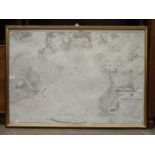
A framed Hydrographic Office Admiralty Chart 'England - South Coast Plymouth Sound', 69 x 98cm, (a/
A framed Hydrographic Office Admiralty Chart 'England - South Coast Plymouth Sound', 69 x 98cm, (a/f).
Los 42
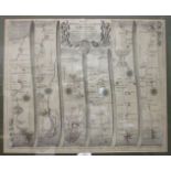
A John Ogilby road map, 'The Road from Bristol to Chester', 35 x 45cm, framed, a smaller road
A John Ogilby road map, 'The Road from Bristol to Chester', 35 x 45cm, framed, a smaller road map, 'Bristol to Chester' from Bowles's Post-chaise ...
Los 43
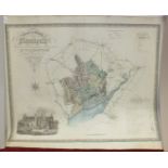
A Greenwood & Co. map of the County of Monmouth, hand-coloured, engraved Josiah Neele, published
A Greenwood & Co. map of the County of Monmouth, hand-coloured, engraved Josiah Neele, published 1831, 63 x 75cm, unframed, three other maps of Mo...