Verfeinern Sie Ihre Suche
Auktionshaus-Kategorie
Filter entfernen- Landkarten (55)
Schätzpreis
Kategorie
Künstler / Marke
Lostyp
Sortieren nach:
- Auktionshaus-Kategorie
- Liste
- Galerie
Ein Abonnement der Preisliste ist notwendig um Ergebnisse, von Auktionen die vor einem längeren Zeitraum als 10 Tagen stattgefunden haben, ansehen zu können. Klicken Sie hier für mehr Informationen

Australasia. A collection of Eighteen maps, mostly 19th-century, including examples by or after Sydney Harbour Trust (publishers), Benard, Bonne, ...
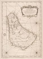
Barbados. Bellin (Jacques Nicolas), Carte de L'Isle de la Barbade Dressee au Depost des Cartes et Plans de la Marine..., Paris 1758, uncoloured en...
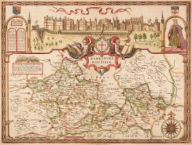
Berkshire. Speed (John), Barkshire Described, John Sudbury & George Humble, circa 1627, hand-coloured engraved map, the upper margin decorated wit...
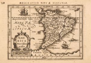
Bertius (Petrus). 6 maps of South America; America Meridionalis, Cerro de Potosi, Peru, Chili, Brasilia, and Magellanici Freti Delineatio [1616-37...
Birmingham. Beilby, Knott & Beilby (publishers), To the Right Honourable William Earl of Dartmouth, Viscount Lewisham &c. &c. the Zealous Promoter...
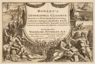
Bowles (Carington, publisher). Bowles's Geographia Classica..., 1784, double-page engraved decorative title, two additional title pages (Bowles's ...
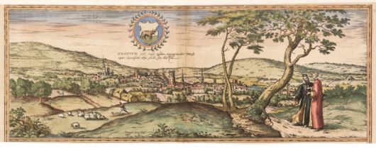
Braun (Georg & Hogenberg Franz). Oxonium nobile Anglie oppidum Septenrionalem..., circa 1575, an engraved panorama of Oxford with contemporary han...
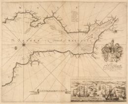
Bristol Channel. Collins (Captain Greenville). Untitled chart of the Bristol Channel, circa 1780
Bristol Channel. Collins (Captain Greenville). Untitled chart of the Bristol Channel, circa 1780, uncoloured engraved sea chart, inset view of the...
British County Maps and others. A good mixed collection of approximately 150 maps, 18th and 19th-century, county, regional and town plans, includi...
British Isles. A collection of 8 maps, mostly 18th & 19th-century, engraved maps, including examples by or after De Rossi, Tirion, Von Reilly, Wae...
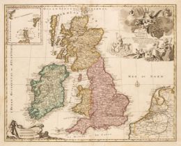
British Isles. Elwe (Ian), Les Isles Britannique qui contiennent les Royaumes d'Angleterre, Ecosse et Irlande..., Amsterdam, 1792, engraved map wi...
British Isles. Jansson (Jan & Ortelius Abraham), Insularum Britannicarum Acurata Delineatio ex Geographicis Conatibus Abrahami Ortelii, Amsterdam,...
![British Isles. Quad (Matthias), Angliae regni florentisimi nova descriptio..., [1600]](https://portal-images.azureedge.net/auctions-2024/srdom10236/images/e269626a-c401-4eb1-9b8d-b13e010b99a7.jpg?h=210)
British Isles. Quad (Matthias), Angliae regni florentisimi nova descriptio auctore Humeredo Lhuyd Denbygiense, Cologne [1592 - 1608], uncoloured e...

Buckinghamshire. Speed (John), Buckingham Both Shyre and Shire Towne describ., published Thomas Bassett and Richard Chiswell, circa 1676, uncolour...
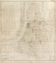
Calcutta. Plan of the City of Calcutta, published under the direction of Colonel St. G. C. Gore, R. E. Surveyor General of India, Calcutta: May 19...
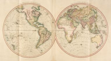
Cary (John). Cary's New Universal Atlas, containing Distinct Maps of all the Principal States and Kingdoms throughout the World from the Latest an...
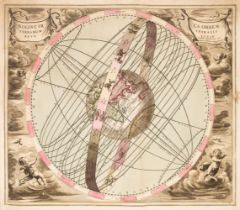
Celestial charts. A collection of eighteen engraved charts, Nuremberg, early to mid 18th century, engraved celestial charts by or after Doppelmayr...
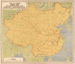
China. Postal Atlas Showing the Postal Establishments and Postal Routes in Each Province, Directorate General of Posts, Nanking, 1933, title pages...
![Derbyshire. Speed (John), Anno Darbieshire described, Thomas Bassett & Richard Chiswell [1676]](https://portal-images.azureedge.net/auctions-2024/srdom10236/images/c72980e8-14fd-48dc-b7cb-b13e010b9d3b.jpg?h=210)
Derbyshire. Speed (John), Anno Darbieshire described, Thomas Bassett & Richard Chiswell [1676]
* Derbyshire. Speed (John), Anno Darbieshire described, Thomas Bassett & Richard Chiswell [1676], hand-coloured engraved map, inset town plan of D...
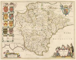
Devon. Blaeu (Johannes), Devonia vulgo Devon-Shire, [1645 or later], engraved map with contemporary outline colouring, decorative cartouche and mi...
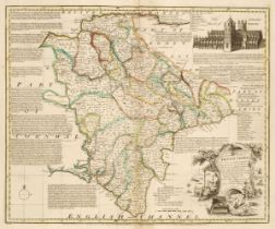
Devon. Bowen (Emanuel). An Accurate Map of Devonshire Divided into its Hundreds..., John Bowles & Son, Messrs. Bakewell & Parker, T. Bowles, H. Ov...
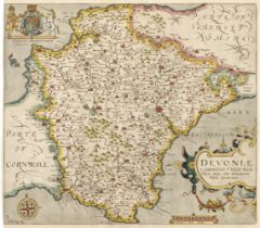
Devon. Saxton (Christopher & Kip Wlliam). Devoniae Comitatus vulgo Denshyre quam olim Danmonii Populi Incolouerunt, [1637], hand-coloured engraved...
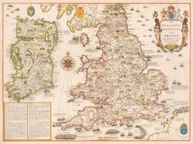
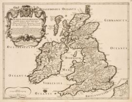
England, Wales & Ireland. Speed (John), The Invasions of England and Ireland with al their Civill Wars since the Conquest, Thomas Bassett & Ricard...
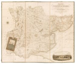
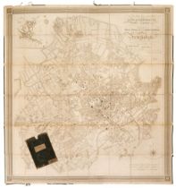
Essex. Greenwood (C & J), Map of the County of Essex, from an actual survey made in the year 1824..., Greenwood, Pringle & Co. July 1st 1825, larg...
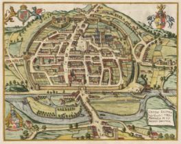
Exeter. Braun (Georg & Hogenberg Frans), Civitas Exoniae (vulgo Excester) Urbs Primaria in Comitatu Devoniae, circa 1617, hand-coloured engraved c...
Folding Maps. A collection of 23 maps, 18th & 19th century, 23 engraved and lithographic map sheets of British county and regional maps and foreig...
Gloucestershire. Speed (John), Glocestershire contrived into thirty thre severall hundreds & those againe into foure principall devisions. The cit...
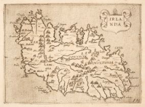
Ireland. Camocio (Giovanni Francesco), Irlanda, published by Fernando Bertelli, Venice, circa 1575, uncoloured engraved map oriented to the east, ...
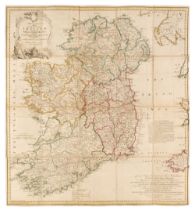
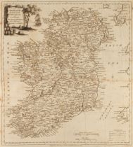
Ireland. Jefferys (Thomas), A New and Accurate Map of the Kingdon of Ireland divided into Provinces, Counties and Baronies; with all the Cities, B...
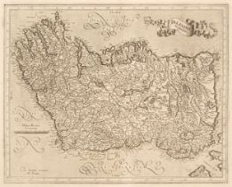
Ireland. Mercator (Gerard), Irlandiae Regnum, circa 1628, uncoloured engraved map, orientated to the east, very slight offsetting, slight creasing...
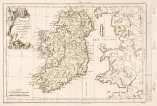
Ireland. Philippe (Pierre), L'Irlande conforme aux Itinéraires et assujettie aux observations astronomiques..., circa 1787, uncoloured engraved ma...
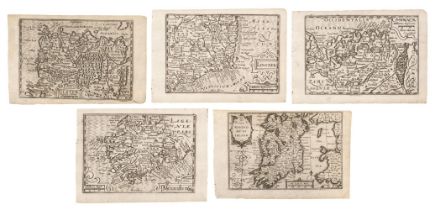
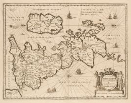
Ireland. Van den Keere (Pieter), The set of five maps of Ireland. The Kingdome of Irland, Ulster, Linster, Connack [and] Mounster, circa 1627, fiv...
![Ireland. Van Loon (H.), Carte Generale des Costes D'Irlande..., [1661 or later]](https://portal-images.azureedge.net/auctions-2024/srdom10236/images/67ee3d54-e0d7-4a15-89a0-b13e010ba659.jpg?h=210)
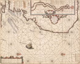
Ireland. Van Loon (Hermanus.), Carte Generale des Costes D'Irlande et des Costes Occidentales D'Angleterre avec une Partie de celles D'Ecosse, [16...
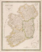
Ireland. Weiland (C. F.). Ireland entworfen und geziechnet..., 1837, engraved map with contemporary outline colouring, slight staining, 615 x 495 ...
Jacobsz (Theunis, 'Lootsman'). Pascaerte van Engelant vant Voorland tot aen Blakeney, circa 1668
Jacobsz (Theunis, 'Lootsman'). Pascaerte van Engelant vant Voorland tot aen Blakeney, waer in te sien is de mont vande Teemse, Amsterdam, circa 16...
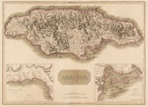
Jamaica. Thomson (John), Jamaica, circa 1817, double-page map engraved by T. Clerk with contemporary outline colouring, inset maps of the Harbours...
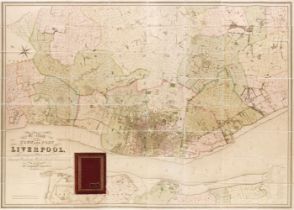
Liverpool. Bennison (Jonathan), A Map of the Town and Port of Liverpool with the Environs including Seacomb, Woodside, Birkenhead, Tranmere &c. fr...
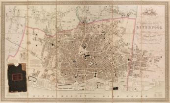
Liverpool. Gage (Michael Alexander), This Trigonometrical Plan of the Town and Port of Liverpool including the environs of Kirkdale Everton Lowhil...
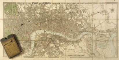
London. Cruchley (G. F.). Cruchley's New Plan of London Improved to 1827. Including the East and West India Docks, 1827, engraved map with contemp...
London. Greenwood (C & J), Map of London from an actual survey..., Greenwood & Co, August 21st,
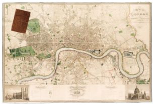
London. Greenwood (C & J), Map of London from an actual survey made in the years 1824, 1825 & 1826..., Greenwood & Co, 1st edition, August 21st, 1...
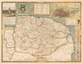
Norfolk. Speed (John), Norfolk a Countie Florishing & Populous Described and Devided..., 1676
Norfolk. Speed (John), Norfolk a Countie Florishing & Populous Described and Devided, with the Armes of such Noble Familes as have borne the title...
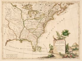
North America. Zatta (Antonio), Il Canada, Le Colonie Inglesi con La Luigiana e Florida, 1778
North America. Zatta (Antonio), Il Canadá, Le Colonie Inglesi con La Luigiana e Florida, Venice, 1778, engraved map with contemporary outline colo...
![Nottinghamshire. Speed (John), The Countie of Nottingham described..., [1676]](https://portal-images.azureedge.net/auctions-2024/srdom10236/images/6bce4dbe-1a12-45f6-91a7-b13e010bacc0.jpg?h=210)
* Nottinghamshire. Speed (John), The Countie of Nottingham described, The Shire Townes Situation and the Earls there of Observed, Thomas Bassett &...
Pine (John). Two sea charts (on one sheet) originally published in 'The Tapestry Hangings of the House of Lords, Representing the Several Engageme...
Ramble (Reuben). Travels through the Counties of England with maps and Historical Vignettes, Darton and Co. circa 1845, decorative frontispiece an...
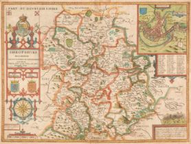
Shropshire. Speed (John), Shropshyre described. The Sittuation of Shrowesbury shewed with the Armes of those Earles and other memorable things obs...
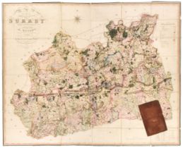
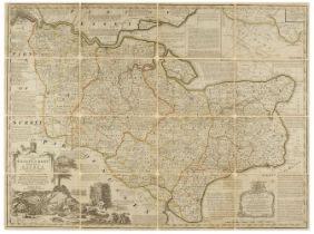
Surrey. Bryant (Andrew), Map of the County of Surrey from actual survey by A. Bryant in the years 1822 and 1823..., June 1st 1823, large scale eng...
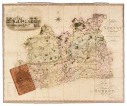
Surrey. Greenwood (C & J), A Map of the County of Surrey from an actual survey made in the years 1822 and 1823, George Pringle Jnr. 1st September ...
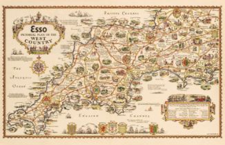
Taylor (A. E.). Four 'Esso' Pictorial maps: Esso Pictorial Plan of the West Country, Esso Pictorial Plan of the Eastern Counties and the Midlands,...
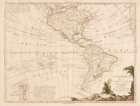
The Americas. Zatta (Antonio), L'America divisa ne' Suoi Principali Stati, Venice, 1770, engraved map with contemporary outline colouring, large m...
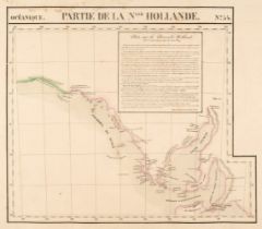
Vandermaelen (Phillipe Marie Guillaume). Fourteen maps: Partie de la Nlle. Hollande No. 35, Partie de la Nlle. Hollande No. 53, Partie de la Nlle...
![Wales. Speed (John), Cardigan Shyre Described..., [1676]](https://portal-images.azureedge.net/auctions-2024/srdom10236/images/52805064-1aa7-4d3e-a2b5-b13e010bb1b2.jpg?h=210)
Wales. Speed (John), Cardigan Shyre Described with the due forme of the Shire town as it was surveyed by J. S. in 1610, Thomas Bassett & Richard C...
Walpoole (George Augustus). The New British Traveller; Or, A Complete Modern Universal Display of Great Britain and Ireland..., Alex Hogg, circa 1...
![Worcestershire. Saxton (Christopher & Lea Philip), Worcestershire and Citty..., [1689 - 94]](https://portal-images.azureedge.net/auctions-2024/srdom10236/images/2b159cdd-c960-43b4-93e4-b13e010bb2ab.jpg?h=210)
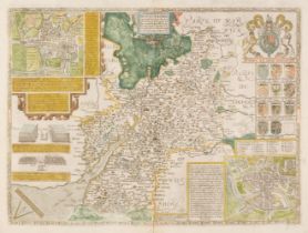
* Worcestershire. Saxton (Christopher & Lea Philip), Worcestershire and Citty exactly described by C. S. newly augmented by Phil. Lea [1689 - 94]...