Verfeinern Sie Ihre Suche
Auktionshaus-Kategorie
Schätzpreis
Kategorie
- Liste
- Galerie
Ein Abonnement der Preisliste ist notwendig um Ergebnisse, von Auktionen die vor einem längeren Zeitraum als 10 Tagen stattgefunden haben, ansehen zu können. Klicken Sie hier für mehr Informationen

Warwickshire. Graphic Illustrations of Warwickshire, [by Alexander Blair], Birmingham & London,
Warwickshire. Graphic Illustrations of Warwickshire, [by Alexander Blair], Birmingham & London, 1829, 32 engraved plates (including frontispiece)...
Yorkshire. A collection of thirty-four volumes relating to Yorkshire topography, history and natural
Yorkshire. A collection of thirty-four volumes relating to Yorkshire topography, history and natural history, mostly 19th & early 20th century, in...
![[Bourguet, Louise]. Trait‚ des P‚trifications. Avec figures, 2 parts in one, 1st edition, Paris:](https://portal-images.azureedge.net/auctions-2017/srdom10099/images/a58140f5-d83f-4bb9-aca1-51957e8f95f9.jpg?w=155&h=155)
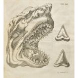
[Bourguet, Louise]. Trait‚ des P‚trifications. Avec figures, 2 parts in one, 1st edition, Paris:
[Bourguet, Louise]. Trait‚ des P‚trifications. Avec figures, 2 parts in one, 1st edition, Paris: Briasson, 1742, 60 folding etched plates, early i...
Buckman (S.S.). Yorkshire Type Ammonites, 2 volumes in 18 parts, London: William Wesley & Son,
Buckman (S.S.). Yorkshire Type Ammonites, 2 volumes in 18 parts, London: William Wesley & Son, 1909-1919, numerous black & white plates from photo...
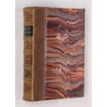
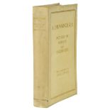
Darwin (Charles). Geological Observations on the Volcanic Islands and Parts of South America visited
Darwin (Charles). Geological Observations on the Volcanic Islands and Parts of South America visited during the Voyage of H.M.S. 'Beagle', 2nd edi...
De La Beche (Henry T.). A Geological Manual, 1st edition, 1831, wood engraved vignette to title,
De La Beche (Henry T.). A Geological Manual, 1st edition, 1831, wood engraved vignette to title, wood engraved illustrations, armorial bookplate o...
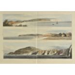
Englefield (Henry C.). A Description of the Principal Picturesque Beauties, Antiquities, and Geological Phoenomena, of the Isle of Wight. With Add...
Geological Survey. Bulletin of the Geological Survey..., volumes 1-2, 4-9 and 12-55, published
Geological Survey. Bulletin of the Geological Survey..., volumes 1-2, 4-9 and 12-55, published 1939-1975, original printed wrappers, 8vo, together...
Greenough (George Bellus). Memoir of a Geological Map of England; to which is added, an Alphabetical
Greenough (George Bellus). Memoir of a Geological Map of England; to which is added, an Alphabetical Index to the Hills, and a List of the Hills a...
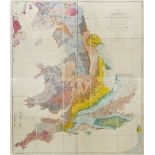
Greenough (George Bellus). A Physical and Geological Map of England & Wales... (on the basis of
Greenough (George Bellus). A Physical and Geological Map of England & Wales... (on the basis of the original Map of Wm. Smith 1815), Revised and I...
Headrick (James). View of the Mineralogy, Agriculture, Manufactures and Fisheries of the Island of
Headrick (James). View of the Mineralogy, Agriculture, Manufactures and Fisheries of the Island of Arran. With Notices of Antquities, and Suggesti...
![[Kendall, Frederick]. A Descriptive Catalogue of the Minerals, and Fossil Organic Remains of](https://portal-images.azureedge.net/auctions-2017/srdom10099/images/aaed8805-6ca5-4d59-f401-43ed2b850402.jpg?w=155&h=155)
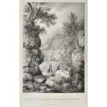
[Kendall, Frederick]. A Descriptive Catalogue of the Minerals, and Fossil Organic Remains of Scarborough and the Vicinity, including the line of C...
Leibnitz (Gottfried Wilhelm). Summi Polyhistoris... Protogaea sive de prima facie Telluris et
Leibnitz (Gottfried Wilhelm). Summi Polyhistoris... Protogaea sive de prima facie Telluris et Antiquissimae Historiae Vestigiis in ipsis Naturae M...
Mantell (Gideon). The Geology of the South-East of England, 1st edition, 1833, lithograph frontispiece, wood engraved vignette title, hand-coloure...
Martin (Peter John). A Geological Memoir on a Part of Western Sussex; with some Observations upon
Martin (Peter John). A Geological Memoir on a Part of Western Sussex; with some Observations upon Chalk-Basins, the Weald-Denudation, and Outlier...
Mawe (John). The Mineralogy of Derbyshire: With a Description of the Most Interesting Mines in the
Mawe (John). The Mineralogy of Derbyshire: With a Description of the Most Interesting Mines in the North of England, in Scotland, and in Wales; an...
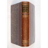
Murchison (Roderick Impey). Siluria. The History of the Oldest known Rocks containing Organic
Murchison (Roderick Impey). Siluria. The History of the Oldest known Rocks containing Organic Remains, with a Brief Sketch of the Distribution of ...
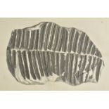
Schlotheim (Freiherrn von). Merkrdige Versteinerungen aus der Petrefactensammlung, Gotha, 1832,
Schlotheim (Freiherrn von). Merkrdige Versteinerungen aus der Petrefactensammlung, Gotha, 1832, 29 engraved and aquatint plates (comprising 27 dou...
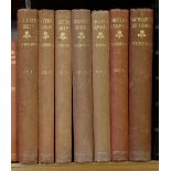
Yorkshire Geological Society. Proceedings of the Yorkshire Geological Society, volumes 1-17, 19-56
Yorkshire Geological Society. Proceedings of the Yorkshire Geological Society, volumes 1-17, 19-56 part 3, 57-60, published 1839-2015, black & whi...
Arkwright (William). The Pointer and his Predecessors. An Illustrated History of the Pointing Dog
Arkwright (William). The Pointer and his Predecessors. An Illustrated History of the Pointing Dog from the Earliest Times, 1st edition, 1902, 40 ...
Burbidge (F.W.). The Narcissus: Its History and Culture with Coloured Plates and Descriptions of all
Burbidge (F.W.). The Narcissus: Its History and Culture with Coloured Plates and Descriptions of all Known Species and Principal Varieties, 1st ed...
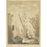
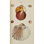
Ellis (John). An Essay Towards a Natural History of the Corallines, and Other Marine Productions
Ellis (John). An Essay Towards a Natural History of the Corallines, and Other Marine Productions of the like kind, Commonly found on the Coasts of...
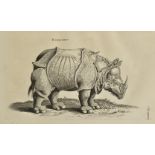
Johnston (John). Theatrum Universale Omnium Animalium... ac plus quam Trecentis Piscibus nuperrime
Johnston (John). Theatrum Universale Omnium Animalium... ac plus quam Trecentis Piscibus nuperrime ex Indiis Orientalibus allatis... cura Henrici ...
Keys (John). The Practical Bee-Master: in which will be Shewn how to Manage Bees either in Straw
Keys (John). The Practical Bee-Master: in which will be Shewn how to Manage Bees either in Straw Hives or in Boxes, without Destroying Them, and w...
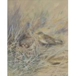
*Lodge (George Edward, 1860-1954). A tree pipit on the ground beside its nest with four eggs,
*Lodge (George Edward, 1860-1954). A tree pipit on the ground beside its nest with four eggs, circa 1950, watercolour and gouache on paper, signe...
Martyn (Thomas). Letters on the Elements of Botany. Addressed to a Lady. By the celebrated J. J.
Martyn (Thomas). Letters on the Elements of Botany. Addressed to a Lady. By the celebrated J. J. Rousseau..., 1st edition in English, 1785, bound...
Masefield (John and Seago, Edward). The Country Scene, 1st edition, Collins, 1937, additional half-
Masefield (John and Seago, Edward). The Country Scene, 1st edition, Collins, 1937, additional half-title, 42 colour plates after Edward Seago, eac...
Morris (Rev. F.O.). A History of British Birds, 6 volumes, 2nd edition, Bell and Daldy, 1870, 365
Morris (Rev. F.O.). A History of British Birds, 6 volumes, 2nd edition, Bell and Daldy, 1870, 365 plates (complete), all with contemporary colouri...
Munnings (Alfred J.). Pictures of Horses and English Life, With an Appreciation by Lionel Lindsay,
Munnings (Alfred J.). Pictures of Horses and English Life, With an Appreciation by Lionel Lindsay, 1st edition, Eyre & Spottiswoode, 1927, additio...
Pratt (Anne). The Flowering Plants and Ferns of Great Britain [with] The British Grasses and Sedges,
Pratt (Anne). The Flowering Plants and Ferns of Great Britain [with] The British Grasses and Sedges, 7 volumes, London: Society for Promoting Chri...
Repton (Humphry). Observations On the Theory and Practice of Landscape Gardening, 1980, black and
Repton (Humphry). Observations On the Theory and Practice of Landscape Gardening, 1980, black and white facsimile illustrations and plates, publi...
Sowerby (James, & Smith, James Edward). English Botany; or coloured figures of British plants with
Sowerby (James, & Smith, James Edward). English Botany; or coloured figures of British plants with their essential characters, synonyms and places...
Sowerby (George Brettingham). The Conchological Illustrations, 1841, 200 hand-coloured engraved
Sowerby (George Brettingham). The Conchological Illustrations, 1841, 200 hand-coloured engraved plates (some heightened with gum arabic), dampstai...
Thorburn (Archibald). British Birds, 4 volumes, 1st edition, Longmans, Green and Co., 1915 - 1916,
Thorburn (Archibald). British Birds, 4 volumes, 1st edition, Longmans, Green and Co., 1915 - 1916, additional half title to each volume, numerous ...
![[Yokohama Nursery Co Ltd]. Rare Hardy Japanese Peonies, Iris, Maples, Magnolias &c [so titled on](https://portal-images.azureedge.net/auctions-2017/srdom10099/images/0793d6fe-18ad-4cdd-8a71-c8d1b3a1d408.jpg?w=155&h=155)
[Yokohama Nursery Co Ltd]. Rare Hardy Japanese Peonies, Iris, Maples, Magnolias &c [so titled on
[Yokohama Nursery Co Ltd]. Rare Hardy Japanese Peonies, Iris, Maples, Magnolias &c [so titled on upper cover], circa 1890, a sample catalogue con...
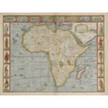
Africa. Speed (John), Africae described, the manners of their habits and buildings newly done into
Africa. Speed (John), Africae described, the manners of their habits and buildings newly done into English, Published Thomas Bassett & Richard Chi...
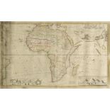
Africa. Moll (Herman), To the Right Honourable Charles Earl of Peterborow and Monmouth &c. This
Africa. Moll (Herman), To the Right Honourable Charles Earl of Peterborow and Monmouth &c. This map of Africa, according to ye newest and most exa...
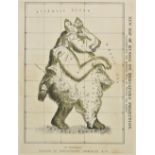
Allegorical map. Smith (J. G.), New Map of Russia on Mercators Projection, illustrating the modest "Will of Peter the Great", published Gortschako...
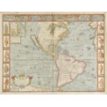
Americas. Speed (John), America with those known parts in that unknowne worlde both people and
Americas. Speed (John), America with those known parts in that unknowne worlde both people and manner of buidings, published Thomas Bassett & Rich...
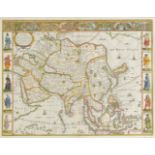
Asia. Speed (John), Asia with the Ilands adjoyning described, the atire of the people & townes of
Asia. Speed (John), Asia with the Ilands adjoyning described, the atire of the people & townes of importance, all of them newly augmented by J. S....
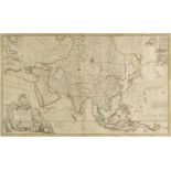
Asia. To the Right Honourable William Lord Cowper, Lord High Chancellor of Great Britian. This map
Asia. To the Right Honourable William Lord Cowper, Lord High Chancellor of Great Britian. This map of Asia according to ye newest and most exact o...
Bertius (Petrus). Liburnia, Larius Lacus, Senense Territorium, Tractus Perusinus [and] Forum
Bertius (Petrus). Liburnia, Larius Lacus, Senense Territorium, Tractus Perusinus [and] Forum Iulii, circa 1616, five uncoloured engraved maps, eac...
British Isles. Jansson (Jan), Insularum Britannicarum Acurata Delineatio ex Geographicis Conatibus
British Isles. Jansson (Jan), Insularum Britannicarum Acurata Delineatio ex Geographicis Conatibus Abrahami Ortelli, published Amsterdam, circa 16...
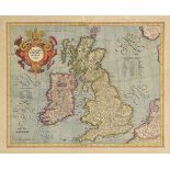
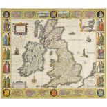
British Isles. Mercator (Gerard & Hondius J.), Anglia, Scotia et Hibernia, circa 1609, engraved
British Isles. Mercator (Gerard & Hondius J.), Anglia, Scotia et Hibernia, circa 1609, engraved map with contemporary hand colouring, large strapw...
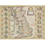
British Isles. Jansson (Jan), Britannia prout divisa suit temporibus Anglo-Saxonum praesertim
British Isles. Jansson (Jan), Britannia prout divisa suit temporibus Anglo-Saxonum praesertim durante illorum Heptarchia, circa 1646, hand coloure...
![British Isles. Fries (Lorenz), Tabu Moder Anglie & Hiber, published Strasburg, [1535], uncoloured](https://portal-images.azureedge.net/auctions-2017/srdom10099/images/d742dd18-3916-4b24-b8de-2e34219b8954.jpg?w=155&h=155)
British Isles. Fries (Lorenz), Tabu Moder Anglie & Hiber, published Strasburg, [1535], uncoloured
British Isles. Fries (Lorenz), Tabu Moder Anglie & Hiber, published Strasburg, [1535], uncoloured woodblock map, slight damp staining to upper mar...
British Isles. A mixed collection of 52 maps, 19th century, engraved and lithographic maps of
British Isles. A mixed collection of 52 maps, 19th century, engraved and lithographic maps of England & Wales and the British Isles, many with han...
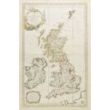
British Isles. Bellin (Jacques Nicolas), Carte reduite des Isles Britanniques, published Paris,
British Isles. Bellin (Jacques Nicolas), Carte reduite des Isles Britanniques, published Paris, 1757, engraved sea chart with contemporary outline...
British Isles Speed (John), Britain as it was devided in the tyme of the Englishe Saxons especially during the Heptarchy, published John Sudbury &...
British Isles. Visscher (Nicolas & Schenk Pieter), Magnae Britanniae tabula comprehendens Angliae,
British Isles. Visscher (Nicolas & Schenk Pieter), Magnae Britanniae tabula comprehendens Angliae, Scotiae ac Hiberniae Regna..., circa 1720, engr...
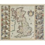
British Isles. Blaeu (Willem J.), Magnae Britanniae et Hiberniae tabula, published Amsterdam,
British Isles. Blaeu (Willem J.), Magnae Britanniae et Hiberniae tabula, published Amsterdam, circa 1630, hand coloured carte-a-figures map with v...
Burden (Philip D.). The Mapping of North America, published Raleigh Publications 1996 [and] The
Burden (Philip D.). The Mapping of North America, published Raleigh Publications 1996 [and] The Mapping of North America II, published Raleigh Pub...
![Caucasus. Ptolemy (Claudius & Holle Lienhart), published Ulm, [1482 - 1486], woodblock map on a](https://portal-images.azureedge.net/auctions-2017/srdom10099/images/56c88146-8a1d-40d7-f244-de27e855f23c.jpg?w=155&h=155)
Caucasus. Ptolemy (Claudius & Holle Lienhart), published Ulm, [1482 - 1486], woodblock map on a
Caucasus. Ptolemy (Claudius & Holle Lienhart), published Ulm, [1482 - 1486], woodblock map on a trapezoidal projection with contemporary hand col...
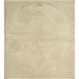
Celestial Charts. Senex (John), A Scheme of the Solar System with the Orbits of the Planets and
Celestial Charts. Senex (John), A Scheme of the Solar System with the Orbits of the Planets and Comets belonging thereto, described by Dr. Halley'...
Coalfield maps. Jordan (Henry K.), South Wales Coal-Field. Monmouthshire area. Horizontal section
Coalfield maps. Jordan (Henry K.), South Wales Coal-Field. Monmouthshire area. Horizontal section Rhymney to Cwmbran, [and] South Wales Coal-Field...
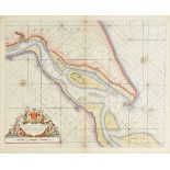
Collins (Captain Greenvile). The River Humber, Burlington Bay Scarbrough & Hartlepoole, Harwich
Collins (Captain Greenvile). The River Humber, Burlington Bay Scarbrough & Hartlepoole, Harwich and two untitled sea charts of the North Sea, circ...
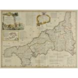
*Cornwall. Kitchin (Thomas), A New Improved Map of Cornwall, from the best Surveys and Intelligences, Divided into its Hundreds..., published C. &...
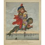
Dighton (Robert). Geography Bewitched! or, a droll Caricature Map of England and Wales, printed
Dighton (Robert). Geography Bewitched! or, a droll Caricature Map of England and Wales, printed for Bowles & Carver, No. 69, St. Paul's Church Yar...
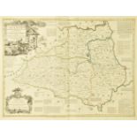
Durham. Kitchin (Thomas), An Accurate Map of the County Palatine of Durham Improved from the best
Durham. Kitchin (Thomas), An Accurate Map of the County Palatine of Durham Improved from the best surveys & intelligences and divided into its war...