Sortieren nach:
- Auktionshaus-Kategorie,
- Kategorie
- Liste
- Galerie
Ein Abonnement der Preisliste ist notwendig um Ergebnisse, von Auktionen die vor einem längeren Zeitraum als 10 Tagen stattgefunden haben, ansehen zu können. Klicken Sie hier für mehr Informationen
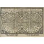

Arthus (Gothard). Historia Indiae Orientalis ex variis auctoribus collecta, et juxta seriem topographicam regnorum, provinciarum & insularum, per ...
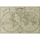
Delisle (Guillaume, and others). Composite Atlas, Paris, circa 1710 - 1800, lacking title and
Delisle (Guillaume, and others). Composite Atlas, Paris, circa 1710 - 1800, lacking title and preliminaries, a composite atlas containing 34 doubl...
Fisquet (Honore Jean Pierre). Grand Atlas D‚partemental de la France de l'Alg‚rie et des colonies,
Fisquet (Honore Jean Pierre). Grand Atlas D‚partemental de la France de l'Alg‚rie et des colonies, volume 1 only (of 2), published Paris: A. Le Va...
Homann (Johann Baptiste and Heirs of). Untitled atlas, circa 1790, lacking title and index, manuscript index tipped in after front endpaper, 58 en...
Martin (R. Montgomery). The British Colonies; their history, extent, condition and resources, 12
Martin (R. Montgomery). The British Colonies; their history, extent, condition and resources, 12 volumes, published J. & F. Tallis, circa 1850, de...
Walker (John). Atlas, circa 1800, lacking title and preliminaries, five double page engraved plates and 24 uncoloured double page engraved maps, m...
Cary (John). Cary's Traveller's Companion, or a Delineation of the Turnpike Roads of England and
Cary (John). Cary's Traveller's Companion, or a Delineation of the Turnpike Roads of England and Wales..., [1792], calligraphic title, advertiseme...
Hall (Sidney). A Travelling Atlas of the English Counties..., published Chapman & Hall, circa
Hall (Sidney). A Travelling Atlas of the English Counties..., published Chapman & Hall, circa 1875, printed title and index, 46 engraved maps with...
Lewis (Samuel, & Co., publishers). Atlas to the Topographical Dictionaries of England and Wales,
Lewis (Samuel, & Co., publishers). Atlas to the Topographical Dictionaries of England and Wales, 1848, frontispiece of a folding engraved map of E...
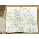
Greenough (George Bellus). Memoir of a Geological Map of England; to which is added, an Alphabetical
Greenough (George Bellus). Memoir of a Geological Map of England; to which is added, an Alphabetical Index to the Hills, and a List of the Hills a...
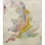
Greenough (George Bellus). A Physical and Geological Map of England & Wales... (on the basis of
Greenough (George Bellus). A Physical and Geological Map of England & Wales... (on the basis of the original Map of Wm. Smith 1815), Revised and I...
Headrick (James). View of the Mineralogy, Agriculture, Manufactures and Fisheries of the Island of
Headrick (James). View of the Mineralogy, Agriculture, Manufactures and Fisheries of the Island of Arran. With Notices of Antquities, and Suggesti...
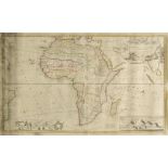
Africa. Speed (John), Africae described, the manners of their habits and buildings newly done into
Africa. Speed (John), Africae described, the manners of their habits and buildings newly done into English, Published Thomas Bassett & Richard Chi...
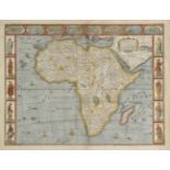
Africa. Moll (Herman), To the Right Honourable Charles Earl of Peterborow and Monmouth &c. This
Africa. Moll (Herman), To the Right Honourable Charles Earl of Peterborow and Monmouth &c. This map of Africa, according to ye newest and most exa...
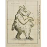
Allegorical map. Smith (J. G.), New Map of Russia on Mercators Projection, illustrating the modest "Will of Peter the Great", published Gortschako...
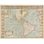
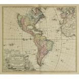
Americas. Speed (John), America with those known parts in that unknowne worlde both people and
Americas. Speed (John), America with those known parts in that unknowne worlde both people and manner of buidings, published Thomas Bassett & Rich...
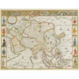
Asia. Speed (John), Asia with the Ilands adjoyning described, the atire of the people & townes of
Asia. Speed (John), Asia with the Ilands adjoyning described, the atire of the people & townes of importance, all of them newly augmented by J. S....
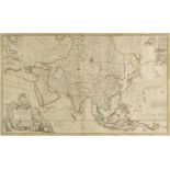
Asia. To the Right Honourable William Lord Cowper, Lord High Chancellor of Great Britian. This map
Asia. To the Right Honourable William Lord Cowper, Lord High Chancellor of Great Britian. This map of Asia according to ye newest and most exact o...
Bertius (Petrus). Liburnia, Larius Lacus, Senense Territorium, Tractus Perusinus [and] Forum
Bertius (Petrus). Liburnia, Larius Lacus, Senense Territorium, Tractus Perusinus [and] Forum Iulii, circa 1616, five uncoloured engraved maps, eac...
British Isles. Jansson (Jan), Insularum Britannicarum Acurata Delineatio ex Geographicis Conatibus
British Isles. Jansson (Jan), Insularum Britannicarum Acurata Delineatio ex Geographicis Conatibus Abrahami Ortelli, published Amsterdam, circa 16...
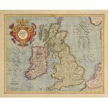
British Isles. Mercator (Gerard & Hondius J.), Anglia, Scotia et Hibernia, circa 1609, engraved
British Isles. Mercator (Gerard & Hondius J.), Anglia, Scotia et Hibernia, circa 1609, engraved map with contemporary hand colouring, large strapw...
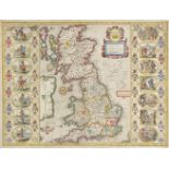
British Isles. Jansson (Jan), Britannia prout divisa suit temporibus Anglo-Saxonum praesertim
British Isles. Jansson (Jan), Britannia prout divisa suit temporibus Anglo-Saxonum praesertim durante illorum Heptarchia, circa 1646, hand coloure...
![British Isles. Fries (Lorenz), Tabu Moder Anglie & Hiber, published Strasburg, [1535], uncoloured](https://portal-images.azureedge.net/auctions-2017/srdom10099/images/d742dd18-3916-4b24-b8de-2e34219b8954.jpg?w=155&h=155)
British Isles. Fries (Lorenz), Tabu Moder Anglie & Hiber, published Strasburg, [1535], uncoloured
British Isles. Fries (Lorenz), Tabu Moder Anglie & Hiber, published Strasburg, [1535], uncoloured woodblock map, slight damp staining to upper mar...
British Isles. A mixed collection of 52 maps, 19th century, engraved and lithographic maps of
British Isles. A mixed collection of 52 maps, 19th century, engraved and lithographic maps of England & Wales and the British Isles, many with han...
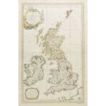
British Isles. Bellin (Jacques Nicolas), Carte reduite des Isles Britanniques, published Paris,
British Isles. Bellin (Jacques Nicolas), Carte reduite des Isles Britanniques, published Paris, 1757, engraved sea chart with contemporary outline...
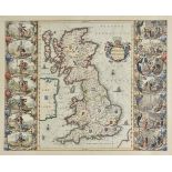
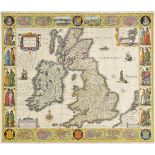
British Isles Speed (John), Britain as it was devided in the tyme of the Englishe Saxons especially during the Heptarchy, published John Sudbury &...
British Isles. Visscher (Nicolas & Schenk Pieter), Magnae Britanniae tabula comprehendens Angliae,
British Isles. Visscher (Nicolas & Schenk Pieter), Magnae Britanniae tabula comprehendens Angliae, Scotiae ac Hiberniae Regna..., circa 1720, engr...
British Isles. Blaeu (Willem J.), Magnae Britanniae et Hiberniae tabula, published Amsterdam,
British Isles. Blaeu (Willem J.), Magnae Britanniae et Hiberniae tabula, published Amsterdam, circa 1630, hand coloured carte-a-figures map with v...
![Caucasus. Ptolemy (Claudius & Holle Lienhart), published Ulm, [1482 - 1486], woodblock map on a](https://portal-images.azureedge.net/auctions-2017/srdom10099/images/56c88146-8a1d-40d7-f244-de27e855f23c.jpg?w=155&h=155)
Caucasus. Ptolemy (Claudius & Holle Lienhart), published Ulm, [1482 - 1486], woodblock map on a
Caucasus. Ptolemy (Claudius & Holle Lienhart), published Ulm, [1482 - 1486], woodblock map on a trapezoidal projection with contemporary hand col...
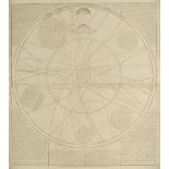
Celestial Charts. Senex (John), A Scheme of the Solar System with the Orbits of the Planets and
Celestial Charts. Senex (John), A Scheme of the Solar System with the Orbits of the Planets and Comets belonging thereto, described by Dr. Halley'...
Coalfield maps. Jordan (Henry K.), South Wales Coal-Field. Monmouthshire area. Horizontal section
Coalfield maps. Jordan (Henry K.), South Wales Coal-Field. Monmouthshire area. Horizontal section Rhymney to Cwmbran, [and] South Wales Coal-Field...
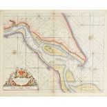
Collins (Captain Greenvile). The River Humber, Burlington Bay Scarbrough & Hartlepoole, Harwich
Collins (Captain Greenvile). The River Humber, Burlington Bay Scarbrough & Hartlepoole, Harwich and two untitled sea charts of the North Sea, circ...
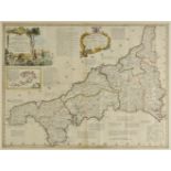
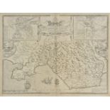
*Cornwall. Kitchin (Thomas), A New Improved Map of Cornwall, from the best Surveys and Intelligences, Divided into its Hundreds..., published C. &...
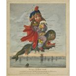
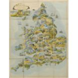
Dighton (Robert). Geography Bewitched! or, a droll Caricature Map of England and Wales, printed
Dighton (Robert). Geography Bewitched! or, a droll Caricature Map of England and Wales, printed for Bowles & Carver, No. 69, St. Paul's Church Yar...
Durham. Kitchin (Thomas), An Accurate Map of the County Palatine of Durham Improved from the best
Durham. Kitchin (Thomas), An Accurate Map of the County Palatine of Durham Improved from the best surveys & intelligences and divided into its war...
England & Wales. Blaeu (Johannes), Anglia Regnum, [1644], engraved map with contemporary hand
England & Wales. Blaeu (Johannes), Anglia Regnum, [1644], engraved map with contemporary hand colouring, slight overall toning, 385 x 500 mm, Lati...
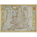
England & Wales. Cary (John), Cary's Six sheet Map of England and Wales with part of Scotland: On
England & Wales. Cary (John), Cary's Six sheet Map of England and Wales with part of Scotland: On which are carefully laid down all the direct and...
England & Wales. Speed (John), The Kingdome of England, published William Humble, 1646, hand
England & Wales. Speed (John), The Kingdome of England, published William Humble, 1646, hand coloured map, engraved by Abraham Goos, eight costume...
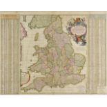
England & Wales. Visscher (Nicolas), A New Mapp of the Kingdome of England, Representing the
England & Wales. Visscher (Nicolas), A New Mapp of the Kingdome of England, Representing the Princedome of Wales and other Provinces, Cities, Mark...
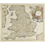
England & Wales. Allard (Carol), Regni Angliae et Walliae Principatus tabula..., published J. Covens
England & Wales. Allard (Carol), Regni Angliae et Walliae Principatus tabula..., published J. Covens & C. Mortier, Amsterdam, circa 1735, hand col...
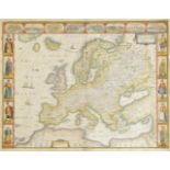
Europe. Speed (John), Europ and the cheife Cities contayned therein described with the habits of
Europe. Speed (John), Europ and the cheife Cities contayned therein described with the habits of most Kingdoms now in use, published Thomas Basset...
Europe. Speed (John), Europe and the cheife Cities contayned therein, described with the habits of
Europe. Speed (John), Europe and the cheife Cities contayned therein, described with the habits of most Kingdoms now in use, published George Humb...
European countries. A mixed collection of 13 maps, mostly 17th - 19th century, including examples by
European countries. A mixed collection of 13 maps, mostly 17th - 19th century, including examples by Coronelli, Jaillot, De Fer, Muller, Russell, ...
Folding maps. A mixed collection of 33 maps, mostly 19th & 20th century, maps of the British
Folding maps. A mixed collection of 33 maps, mostly 19th & 20th century, maps of the British Isles, English Counties and overseas, including Wyld...
France. A mixed collection of 34 maps, 17th - 19th century, country, regional and town plans of
France. A mixed collection of 34 maps, 17th - 19th century, country, regional and town plans of France, including examples by De Fer, Sanson, Noli...
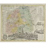
Germany. Homann (Johann Baptist, heirs of), Tractus Nordlingensis Germ. Ries dicti accurata descriptio..., 1738, engraved map with contemporary ha...
Glamorganshire. Speed (John), Glamorgan Shyre with the sittuations of the chiefe towne Cardyff and
Glamorganshire. Speed (John), Glamorgan Shyre with the sittuations of the chiefe towne Cardyff and ancient Landaffe described, published Thomas Ba...
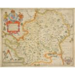
Hertfordshire. Saxton (Christopher), Hartfordiae comitatus nova uera ac particularis descriptio..., circa 1579, hand coloured map, engraved by Nic...
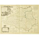
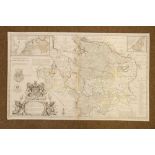
Lancashire. Greenwood (C. & J.), Map of the County Palatine of Lancaster from an actual survey,
Lancashire. Greenwood (C. & J.), Map of the County Palatine of Lancaster from an actual survey, published February 24th, 1830, hand coloured engra...
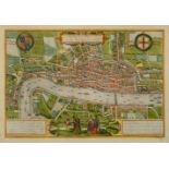
London. A new and complete plan of London Westminster and Southwark with the aditional buildings
London. A new and complete plan of London Westminster and Southwark with the aditional buildings to the year 1777, hand coloured engraved plan, or...
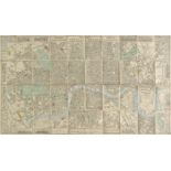
London. Wyld (James), Wyld's New Plan of London, published June 1866, folding lithograph map with
London. Wyld (James), Wyld's New Plan of London, published June 1866, folding lithograph map with sparse contemporary hand colouring, laid on line...
London. Braun (Georg & Hogenberg Frans), Londinum Feracissimi Angliae Regni Metropolis, published
London. Braun (Georg & Hogenberg Frans), Londinum Feracissimi Angliae Regni Metropolis, published Cologne, [1572 - 1574], hand coloured engraved ...
London. Willdey (George), A New & Correct Map of Thirty Miles Round London Shewing all the Towns,
London. Willdey (George), A New & Correct Map of Thirty Miles Round London Shewing all the Towns, Villages Roads &c. with the Seats of the Nobilit...
Map game. Wallis (Edward), Wallis's Picturesque Round Game of the Produce and Manufactures of the
Map game. Wallis (Edward), Wallis's Picturesque Round Game of the Produce and Manufactures of the Counties of England & Wales, circa 1830, aquatin...
Maps. A mixed collection of 50 maps, mostly 18th & 19th century, engraved maps, several with
Maps. A mixed collection of 50 maps, mostly 18th & 19th century, engraved maps, several with contemporary hand colouring including 16 county maps ...
*Maps. A mixed collection of 14 maps, mostly 19th & early 20th century, including Levasseur (
*Maps. A mixed collection of 14 maps, mostly 19th & early 20th century, including Levasseur (Victor), A set of the world and six continents and su...
Maps. A mixed collection of approximately 100 British & overseas maps, 18th & 19th century, engraved
Maps. A mixed collection of approximately 100 British & overseas maps, 18th & 19th century, engraved maps, including examples by Kitchin, Hall, Ru...
Maps. A mixed collection of approximately 130 British and overseas maps, mostly 18th & 19th century,
Maps. A mixed collection of approximately 130 British and overseas maps, mostly 18th & 19th century, engraved maps of British counties and foreign...
Moll (Herman). A New Map of Germany, Hungary, Transilvania & The Suisse..., published J. Bowles,
Moll (Herman). A New Map of Germany, Hungary, Transilvania & The Suisse..., published J. Bowles, P. Overton & T. Bowles, circa 1720, Les Provinces...