Sortieren nach:
- Kategorie
- Liste
- Galerie
Ein Abonnement der Preisliste ist notwendig um Ergebnisse, von Auktionen die vor einem längeren Zeitraum als 10 Tagen stattgefunden haben, ansehen zu können. Klicken Sie hier für mehr Informationen
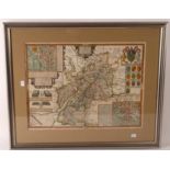

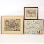
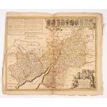
John Speed (1552-1629)/County map of Gloucestershire/hand coloured map (first printed in 1610),
John Speed (1552-1629)/County map of Gloucestershire/hand coloured map (first printed in 1610), 39cm x 51cm
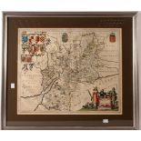
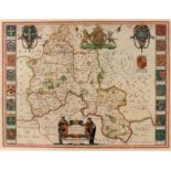
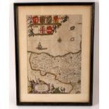
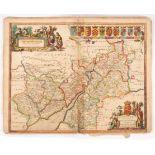
Johannes Blaeu (1650-1712)/Glocestria Ducatus Vulgo Glocester/hand coloured map, 41cm x 50cm
Sutton Nicholls (Engraver)/A County Map of Cambridgeshire/hand coloured engraving, 44cm x 38cm ...[more]
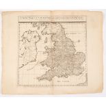
John Smith (Fl.
John Smith (Fl. 1720)/A New Map of South Britain of England and Wales/uncoloured and unframed
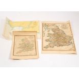
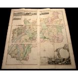
Saxton (Christopher) and Lea (Philip) Comberland and Westmorland, exactly described by CS, corrected and amended with many additions by P Lea/colo...
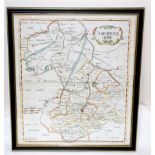
Jan Jansson (1588-1664)/Oxonium Comitatus Vulgo Oxfordshire/hand coloured engraved map, 38.5cm x 50cm
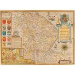
John Speed (1552-1629)/Northumberland/with descriptive text on reverse/hand coloured engraved maps,
John Speed (1552-1629)/Northumberland/with descriptive text on reverse/hand coloured engraved map, 39cm x 46cm ...[more]
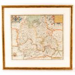
Christopher Saxton (1540-1610)/Oxfordshire, Berkshire and Buckinghamshire/coloured engraved map, 39.
Christopher Saxton (1540-1610)/Oxfordshire, Berkshire and Buckinghamshire/coloured engraved map, 39.5cm x 46cm
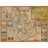
John Speed (1552-1629)/The Countie Pallatine of Lancaster/described and divided into hundreds,
John Speed (1552-1629)/The Countie Pallatine of Lancaster/described and divided into hundreds, dated 1610/hand coloured engraved map, 39cm x 51.5c...
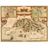
John Speed (1552-1629)/Glamorganshyre/with the situations of the chief Townes Cardyff and ancient
John Speed (1552-1629)/Glamorganshyre/with the situations of the chief Townes Cardyff and ancient Landaffe described, 1646 edition/text on reverse...
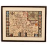
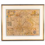
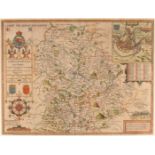
John Speed (1552-1629)/Oxfordshire/described with ye Citie and Armes of the Colledges of ye famous
John Speed (1552-1629)/Oxfordshire/described with ye Citie and Armes of the Colledges of ye famous University 1605/text on reverse/coloured engrav...
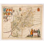
John Blaeu (1596-1673)/Oxonium Comitatus, Vulgo Oxfordshire/text on reverse/coloured engraved map,
John Blaeu (1596-1673)/Oxonium Comitatus, Vulgo Oxfordshire/text on reverse/coloured engraved map, circa 1645 39cm x 51cm/see illustration
John Speed (1552-1629)/The Countie and Citie of Lyncolne/described with the Armes of them that have
John Speed (1552-1629)/The Countie and Citie of Lyncolne/described with the Armes of them that have bene Earles Thereof Since the Conquest/text on...
John Speed (1552-1629)/Shropshyre/described the sittuation of Shrowesbury Shewed/text on reverse/coloured engraved map, 39cm x 51cm
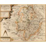
Christopher Saxton (1540-1610)/Warwici Countatus Cornaviis Olim Inhabitus/first edition 1607,
Christopher Saxton (1540-1610)/Warwici Countatus Cornaviis Olim Inhabitus/first edition 1607, text on reverse/coloured engraved map, 28.5cm x 30.5...
Menke/Ancient World/coloured engraved map, 21.5cm x 28cm/and two facsimiles of 17th Century maps
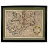
Gerard Mercator/Irlandiae Regnum/coloured engraved map, 35cm x 47cm
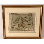
Girolamo Ruscelli/Tabula Europae/colour engraved map with text on reverse, 19.5cm x 26cm
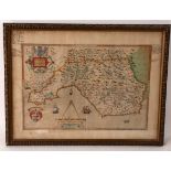
Christopher Saxton (1540-1610), Glamorgan Comitatus Australis Cambrige pars descriptio Ano Dni 1578,
Christopher Saxton (1540-1610), Glamorgan Comitatus Australis Cambrige pars descriptio Ano Dni 1578, the margin with annotation in ink, colour eng...
Jansson, 1646, Somersettensis Comitatus Somerset Shire, colour engraved part map, to Dtert Poynt,
Jansson, 1646, Somersettensis Comitatus Somerset Shire, colour engraved part map, to Dtert Poynt, with armorial and vignette of shepherds with she...
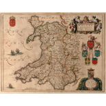
Jansson Blaeu (1596-1673), Wallia Principatus Vulgo Wales, colour engraved map, 38.5cm x 49cm/see illustration
Johannes Blaeu (1650-1712)/Glocestria Ducatus Vulgo Glocestershire/circa 1648/colour engraved map,
Johannes Blaeu (1650-1712)/Glocestria Ducatus Vulgo Glocestershire/circa 1648/colour engraved map, 45cm x 56cm (unframed)/see illustration
Johannes Blaeu (1650-1712)/Glocestria Ducatus Vulgo Glocestershire/engraved map, 45cm x 56cm (unframed)
Joannes Janssonius (1588-1664)/Glocester Shire and Monmouth Shire/with the Post and Crossroads and
Joannes Janssonius (1588-1664)/Glocester Shire and Monmouth Shire/with the Post and Crossroads and other remarks according to the latest and best ...
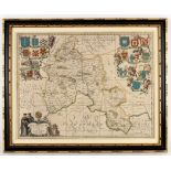
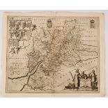
Joannes Janssonius (1588-1664)/Glocestria Ducatus cum Monumethensi Comitatu/colour engraved map,
Joannes Janssonius (1588-1664)/Glocestria Ducatus cum Monumethensi Comitatu/colour engraved map, 43cm x 55cm (unframed)/see illustration
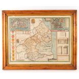
Isaac Taylor/Map of the County of Gloucestershire/with engravings of Berkeley, St Briavels, Beveston, Sudeley and Thornbury castles and vignette b...
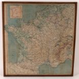
A silk map showing Former Occupied Areas of France, 57.5cm x 55cm