Filtered by:
- Category
- List
- Grid
A subscription to the Price Guide is required to view results for auctions ten days or older. Click here for more information
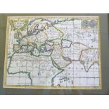

Jean le Clerc/Nicholas Sanson: La Terre Connue Lorsque L~Evangil sut Publie, engraved hand coloured maps circa 1705, inset double hemisphere world...
![Robert Morden: Comitatus den Rotlandiae Tabula Nova Aucta [Rutland], engraved map [circa 1695],](https://portal-images.azureedge.net/auctions-2021/srkey10584/images/b8ad32d8-6cc2-4046-a07b-adc0011c643d.jpg?w=155&h=155)
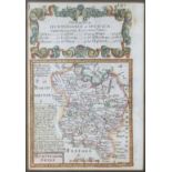
Robert Morden: Comitatus den Rotlandiae Tabula Nova Aucta [Rutland], engraved map [circa 1695],
Robert Morden: Comitatus den Rotlandiae Tabula Nova Aucta [Rutland], engraved map [circa 1695], framed and glazed, approx size 370 x 290mm
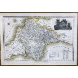
JAMES PIGOT: DEVONSHIRE, engraved part hand coloured map circa 1844, vignette of Exeter Cathedral,
JAMES PIGOT: DEVONSHIRE, engraved part hand coloured map circa 1844, vignette of Exeter Cathedral, approx 220 x 345mm, framed and glazed
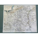
CHRISTOPHER SAXTON/WILLIAM KIP: RADNOR COMITATUS QUEM SILVRES, engraved part hand coloured map circa
CHRISTOPHER SAXTON/WILLIAM KIP: RADNOR COMITATUS QUEM SILVRES, engraved part hand coloured map circa 1610, approx 260 x 315mm, framed and glazed
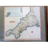
SAMUEL JOHN NEELE: CORNWALL, engraved hand coloured map pub Cadell & Davies, 1814, inset Scilly
SAMUEL JOHN NEELE: CORNWALL, engraved hand coloured map pub Cadell & Davies, 1814, inset Scilly Isles, approx 370 x 410mm, framed and glazed ...[...
![JOHN SPEED: DENBIGHSHIRE, engraved hand coloured map [1611], approx 380 x 510mm, framed and glazed](https://portal-images.azureedge.net/auctions-2021/srkey10584/images/315d952f-6e79-42ce-a5eb-adc0011c6746.jpg?w=155&h=155)
JOHN SPEED: DENBIGHSHIRE, engraved hand coloured map [1611], approx 380 x 510mm, framed and glazed
JOHN SPEED: DENBIGHSHIRE, engraved hand coloured map [1611], approx 380 x 510mm, framed and glazed
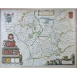
JOAN BLAUE: LEICENTRENSIS COMITATUS, engraved hand coloured map circa 1645, approx 380 x 500mm,
JOAN BLAUE: LEICENTRENSIS COMITATUS, engraved hand coloured map circa 1645, approx 380 x 500mm, framed and glazed
![RICHARD BLOME: A MAPP OF YE COUNTY OF ESSEX, engraved hand coloured map [1673], approx 255 x](https://portal-images.azureedge.net/auctions-2021/srkey10584/images/e8acdf97-b147-4f5c-88ec-adc0011c6961.jpg?w=155&h=155)
RICHARD BLOME: A MAPP OF YE COUNTY OF ESSEX, engraved hand coloured map [1673], approx 255 x
RICHARD BLOME: A MAPP OF YE COUNTY OF ESSEX, engraved hand coloured map [1673], approx 255 x 320mm, framed and glazed
![ROBERT MORDEN: THE EAST RIDING OF YORKSHIRE, engraved hand coloured map [1695], approx 355 x](https://portal-images.azureedge.net/auctions-2021/srkey10584/images/5b0d9805-696b-48f0-afb0-adc0011c6a58.jpg?w=155&h=155)
ROBERT MORDEN: THE EAST RIDING OF YORKSHIRE, engraved hand coloured map [1695], approx 355 x
ROBERT MORDEN: THE EAST RIDING OF YORKSHIRE, engraved hand coloured map [1695], approx 355 x 420mm, framed and glazed
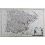
![ROBERT MORDEN: ENGLAND, engraved hand coloured map [1695], approx 355 x 420mm, framed and glazed](https://portal-images.azureedge.net/auctions-2021/srkey10584/images/f576c3d1-6703-4474-9830-adc0011c6b70.jpg?w=155&h=155)
ROBERT MORDEN: ENGLAND, engraved hand coloured map [1695], approx 355 x 420mm, framed and glazed
ROBERT MORDEN: ENGLAND, engraved hand coloured map [1695], approx 355 x 420mm, framed and glazed
![ROBERT MORDEN: 2 engraved hand coloured maps comprising LEICESTER SHIRE [1695], approx 355 x](https://portal-images.azureedge.net/auctions-2021/srkey10584/images/ec1701ce-2ab2-409d-a91f-adc0011c6c4a.jpg?w=155&h=155)
ROBERT MORDEN: 2 engraved hand coloured maps comprising LEICESTER SHIRE [1695], approx 355 x
ROBERT MORDEN: 2 engraved hand coloured maps comprising LEICESTER SHIRE [1695], approx 355 x 420mm, framed and glazed; WARWICK SHIRE [1695], appro...
ANTONIO ZATTA: PROVINCIA DI ESSEX, engraved hand coloured map, 1779, approx 190 x 295mm, framed
ANTONIO ZATTA: PROVINCIA DI ESSEX, engraved hand coloured map, 1779, approx 190 x 295mm, framed and glazed + ROBERT MORDEN: DEARBYSHIRE, engraved ...
![ROBERT MORDEN: STAFFORD SHIRE, engraved hand coloured map [1695], approx 430 x 365mm, framed and](https://portal-images.azureedge.net/auctions-2021/srkey10584/images/06f06e0c-1af3-4c76-9909-adc0011c6e62.jpg?w=155&h=155)
ROBERT MORDEN: STAFFORD SHIRE, engraved hand coloured map [1695], approx 430 x 365mm, framed and
ROBERT MORDEN: STAFFORD SHIRE, engraved hand coloured map [1695], approx 430 x 365mm, framed and glazed
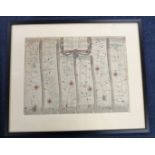
OWEN/BOWEN, 2 hand coloured engraved road maps, 1736, printed recto and verso, comprising THE ROAD
OWEN/BOWEN, 2 hand coloured engraved road maps, 1736, printed recto and verso, comprising THE ROAD FROM YORK TO WHITBY AND SCARBOROUGH, inset map ...
GILLES ROBERT DE VAUGONDY: LE ROYAUM D~ANGLETERRE..., engraved outline coloured map, circa 1753,
GILLES ROBERT DE VAUGONDY: LE ROYAUM D~ANGLETERRE..., engraved outline coloured map, circa 1753, approx 475 x 510mm, framed and glazed
OWEN/BOWEN: 3 hand coloured engraved road maps circa 1736, printed recto and verso, comprising THE
OWEN/BOWEN: 3 hand coloured engraved road maps circa 1736, printed recto and verso, comprising THE ROAD FROM BRISTOL TO WESTCHESTER..., inset map ...
JOAN BLAEU: REGIONES INUNDATAE IN FINIBUS COMITATUS NORFOLCIAE SUFFOLCIAE CANTABRICIAE..., engraved hand coloured map circa 1645, approx 430 x 540...
JOHN OGILBY: THE ROAD FROM IPSWICH COM SUFFOLK TO NORWICH AND THENCE TO CROMER..., engraved hand
JOHN OGILBY: THE ROAD FROM IPSWICH COM SUFFOLK TO NORWICH AND THENCE TO CROMER..., engraved hand coloured road map circa 1698, plate 74, approx 32...
![ROBERT MORDEN: THE EAST RIDING OF YORKSHIRE, engraved hand coloured map [1695], browned, approx](https://portal-images.azureedge.net/auctions-2021/srkey10584/images/cbcf0a09-5ad3-4dbf-9a40-adc0011c7472.jpg?w=155&h=155)
ROBERT MORDEN: THE EAST RIDING OF YORKSHIRE, engraved hand coloured map [1695], browned, approx
ROBERT MORDEN: THE EAST RIDING OF YORKSHIRE, engraved hand coloured map [1695], browned, approx 355 x 420mm, framed and glazed
![JOHN SPEED: NORFOLK..., engraved hand coloured map [1627], approx 375 x 505mm, double glazed](https://portal-images.azureedge.net/auctions-2021/srkey10584/images/fec93dd8-43d2-4079-b412-adc0011c7cf7.jpg?w=155&h=155)
JOHN SPEED: NORFOLK..., engraved hand coloured map [1627], approx 375 x 505mm, double glazed
JOHN SPEED: NORFOLK..., engraved hand coloured map [1627], approx 375 x 505mm, double glazed
![JOHN SPEED: THE COUNTYE PALATINE OF CHESTER..., engraved part hand coloured map [1676], approx 380 x](https://portal-images.azureedge.net/auctions-2021/srkey10584/images/91a5a824-0ee3-47b4-9320-adc0011c7ddd.jpg?w=155&h=155)
JOHN SPEED: THE COUNTYE PALATINE OF CHESTER..., engraved part hand coloured map [1676], approx 380 x
JOHN SPEED: THE COUNTYE PALATINE OF CHESTER..., engraved part hand coloured map [1676], approx 380 x 505mm, framed and glazed
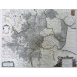
![CHRISTOPHER SAXTON/WILLIAM KIP: NORFOLCIAE COMITATUS..., engraved hand coloured map [1637], approx](https://portal-images.azureedge.net/auctions-2021/srkey10584/images/3d430e88-b5be-474b-aef7-adc0011c8052.jpg?w=155&h=155)
CHRISTOPHER SAXTON/WILLIAM KIP: NORFOLCIAE COMITATUS..., engraved hand coloured map [1637], approx
CHRISTOPHER SAXTON/WILLIAM KIP: NORFOLCIAE COMITATUS..., engraved hand coloured map [1637], approx 265 x 380mm, framed and glazed
![ROBERT MORDEN: 3 engraved maps [1695], Leicestershire, Northamptonshire and Huntingtonshire,](https://portal-images.azureedge.net/auctions-2021/srkey10584/images/2a3277a8-bb80-4b98-b9f8-adc0011c8117.jpg?w=155&h=155)
ROBERT MORDEN: 3 engraved maps [1695], Leicestershire, Northamptonshire and Huntingtonshire,
ROBERT MORDEN: 3 engraved maps [1695], Leicestershire, Northamptonshire and Huntingtonshire, approx 355 x 410mm (3) ...[more]
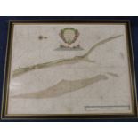
GREENVILLE COLLINS: 2 engraved hand coloured sea charts from GREAT BRITAIN~S COASTING PILOT, first
GREENVILLE COLLINS: 2 engraved hand coloured sea charts from GREAT BRITAIN~S COASTING PILOT, first published in 1693 with various re-issues 1723-1...
J WALLIS: 11 assorted engraved hand coloured England county maps circa 1819, approx 130 x 90mm + 5
J WALLIS: 11 assorted engraved hand coloured England county maps circa 1819, approx 130 x 90mm + 5 folding English county maps + one other (17) ....