


Lotto 188
A Good Philips 4in Terrestrial Globe,
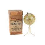
A Good Philips 4in Terrestrial Globe, English, c.1870 (as the globe shows the Sandwich islands and 'the dominion of Canada' indicating an age of c...
Explore an enormous array of collectables auctions on the UK's leading online auction marketplace. Browse models, toys, dolls, games, arms, armour, militaria, books & periodicals, sporting equipment & memorabilia, musical instruments, stamps, coins, classic cars & motorcycles, camera & camera equipment, wines & spirits, maps, religious items & folk art, banknotes, entertainment memorabilia, and more. With so many reputable auction houses selling on the saleroom, you can find the collectables auctions you're looking for and more. Use tools like watch lists, auction alerts, filters, and more to speed up your search and compete in live and timed auctions. Place winning bids on the items that match your criteria and get your next collectable on the saleroom.
A Good Philips 4in Terrestrial Globe, English, c.1870 (as the globe shows the Sandwich islands and 'the dominion of Canada' indicating an age of c...
Set of six framed WWII original hand sketched D-Day weather forecast charts dating from the 3rd to the 7th of June, Acquired by Captain David Davi...
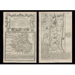
Title: Bowen 290 Yrs Old Detailed Road Map Whitby to Durham Newcastle North East. Description: Bowen 290 Yrs Old Detailed Road Map ...
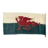
EARLY WELSH FLAG (Y DDRAIG GOCH), circa 1960s, printed cotton with stitched edge and 'British Made' in the print, 43 x 88cms, affixed to short bam...
An old OS map of The Isle of Wight
A 2 ¾-inch terrestrial pocket globe after Herman Moll, English, circa 1775, the rectangular cartouche inscribed A Correct Globe With The New D...
Charles William Bartlett (1860-1940) - 'The Yellow River, China, signed, limited 52/75 woodcut, 18 x 31cm, framed
12 Maps of India Survey of India early 20th century 12 canvas-backed colour maps. English Good, used condition.
'The Map of The Isle of Wight' by A BRANNON - a print - framed and glazed
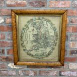
Large framed sampler tapestry depicting United Kingdom map surrounded by floral wreath , Signed Carolene Everett & dated 1835, H 61cm x 57cm
A rare John Miller 3-inch pocket globe, Scottish, published 1793, cartouche printed A NEW GLOBE of the Earth By John Miller Mathematical Instru...
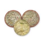
POCKET GLOBE; FOREST, J. [Globe Terrestre.] Paris: Forest, Géographe-Éditeur, 17 Rue de Buci, c.1930. A 3 inch (7.7 cm) diameter pocket globe o...
TWO LEATHER CASES OF JOHNSTONS THREE MILES TO INCH MAPS, ONE CONTAINING MAPS OF SCOTLAND AND THE OTHER OF ENGLAND AND WALES
A 19th century hand coloured Cornish mining print "Digging for Tin Under the Sea in Cornwall" after Harold Oakley, the footnote details "This Diag...
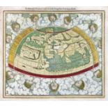
WORLD MAP -- "PTOLEMEISCH GENERAL TAFEL / die halbe Kugel der Welt begreiffende". (Basel, c. 1590). Handcold. woodcut double-page map from S. Muns...
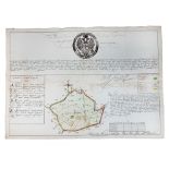
BELARUS -- MANUSCRIPT MAP of the Belarusian city of Polotsk. (1786). Plan of Polotsk drawn on blueish paper by Ivan Abramovich (?), cold. by hand,...
WORSLEY, Richard. The History of the Isle of Wight. London: A. Hamilton, 1781. First edition, 4to (307 x 229mm.) Large folding engraved map of Isl...
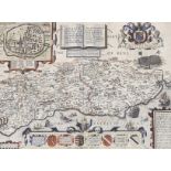
JOHN SPEED coloured 1610 copper engraved map - entitled in cartouche 'Caermarden, Both Shyre and Town described', with inset plan of Carmarthen to...
DEVON. Speed, John. Devonshire with Excester Described, an engraved county map, hand coloured, to be sold by Bassett & Chiswell (1676 edn.), in a ...
Large framed Victorian childrens sampler with religious text, 59 x 59cm
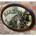
Advertising - original 1930s Marston's Burton Ales hand painted framed oval mirror, with original pub label verso, 60cm x 85cm
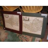
Two early 19th century printed panels - a map of Ireland published 1812 by Laurie and Whittle and a map of England and Wales, 55cm x 45cm
A believed 17th century hand coloured engraved map of the hypothetical continent Magellanica. The map in Spanish, marked to lower right hand corne...
'A New and Corrected Map of the Isle of Wight' by G Brannon - framed and glazed
Robert Morden - a 17th century hand coloured map of Dorsetshire, together with Somerset
10IN. TERRESTRIAL GLOBE PUBLISHED BY PHILIPS LONDON, CIRCA 1961 12 two part coloured gores, maker's cartouche inscribed ' challenge globe ,' mou...
ALLEGORICAL MAP -- (EUROPA REGINA, Queen Europe). (Basel, H. Petri, 1588). Plain allegorical woodcut map from S. Munster's 'Cosmographey', German ...
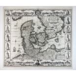
DENMARK -- "DANIAE REGNI TYPUM". (Amst.), J. Janssonius, 1629. Plain engr. map incorporating 8 city views (incl. Copenhagen, Helsingør, Lubeck, an...
EASTERN EUROPE -- POLAND -- "ZAMOSCIUM, Nova Poloniæ civitas, (…)". (Cologne, Braun & Hogenberg, 1617/18). Engr. view of Zamosc. 337 x 495 mm. (Ma...
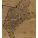
C17th map of the West Riding of Yorkshire
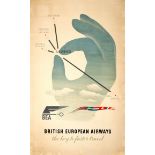
Original vintage travel advertising poster for BEA British European Airways featuring a great mid-century illustration by the notable graphic desi...
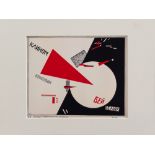
El Lissitzky (1890-1941) – Graphic, contructivist composition, described on the bottom, on paper, in passepartout, 22 x 25 cm
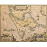
An unframed map of Northern India, Nepal and Pakistan, ' Magni Margolis ', Imperium, circa 1650 by Cornelius Blaeu, 48.5 x 57cm, including full m...
ROBERT MORDEN: TWO HAND COLOURED ENGRAVED MAPS COMPRISING SOMERSETSHIRE AND GLOUCESTERSHIRE, 42 x 36cms and 41.5 x 34cms. (2)
ALLEGORICAL MAP -- "EUROPA Volgens de nieuwste Verdeeling". Haarlem, F. Bohn, (1794). Cont. handcold. allegorical engr. map. 237 x 167 mm. (Left b...
SPEED, John. Devonshire with Excester Described, published by John Sudbury & George Humble 1623, hand coloured map, Exeter shown in an inset to on...
A WW2 Near East RAF / Special Forces silk escape map - printed double sided map K1/K2 Cyrenaica North Africa, scale 1:1,657,000, 47 x 54.5 cm. *...
Very large National Geographic framed map of the world, 112cm x 78cm
TWENTY-TWO VINTAGE MAPS, some cloth-backed, to include Ordnance Survey, Bartholomew's, R.A.F and Duckham's
Vienna Artist around 1815, two views of Vienna on one paper page, monogrammed AC ? and dated 1815 and described, in passepartout, 30 x 44 cm, blac...
A rare collection of WW2 Maps of the Tobruk together with canvas map case
Rare 1950s clapperboard white printed Prod, A Night To Remember then divided into Slate and Take. 8ins. x 6ins.
A selection of Indian related engravings and maps including "Plan of the Cantonment of Ootacamund 1841"; pen and ink sketch of a balcony scene; a ...
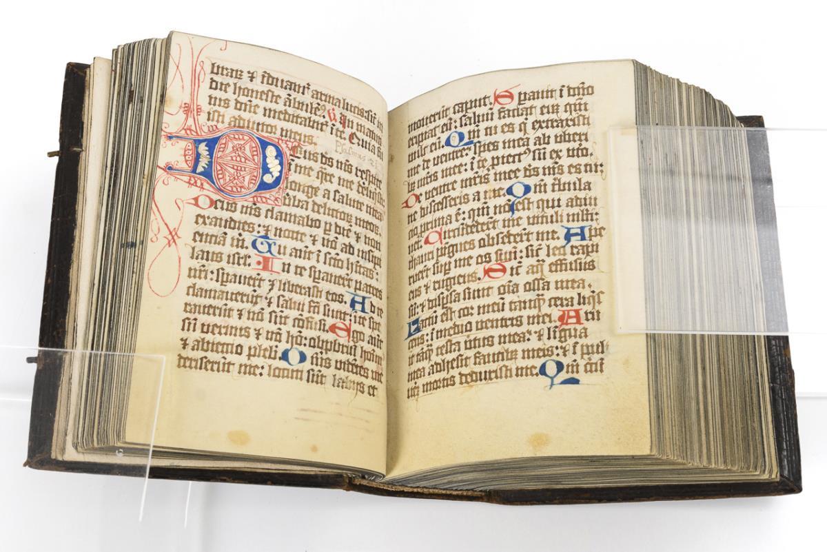
[ATLAS] COLE and ROPER. Nightingale, Joseph. English Topography: or, a series of … Counties of England and Wales. Accompanied by a Map of each Cou...
SPEED, John. Kent, with her Cities and Earles described and observed, hand coloured map with inset plans of Rochester and Canterbury, English text...
C17th map of Saxton-Monmouth Monumethenis by Kip & Hole circa 1637, uncoloured and unframed, 39cm x 32.5cm
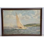
Framed and glazed picture "sailing off the Isle of Wight", approx 74cm x 49cm
Advertising - A Michelin tin wall sign depicting a map of the British Isles, approx 86cm x 63cm
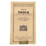
SCALE 1 : 4,000,000 Map of India with Ceylon, Burma & Baluchistan. In Contour Colouring, showing roads, airports, etc. Scale 1 : 4,000,000 Barth...
*Local Interest - After Jones, Smith, & Co. (19th Century, British), coloured print, 'A New Map of the County of Cumberland divided into Wards', f...
Constable's Hand Atlas of India Archibald Constable & Company Westminster 1893 Half morocco, gilt stamped cloth boards, top edge gilt. 117 pages o...
Thackers Reduced Survey Map of India Thacker, Spink, & Co. Calcutta 1925 Pamphlet and map in boards. 62 page index. Large fold-out map. English Co...
John Norden (1546-1625), hand coloured map of Sussex, sold by John Sudbury and George Humble, text verso, 39 x 51cm
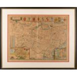
John Speed (1552-1629) hand coloured map of Hertfordshire, sold by John Sudbury and George Humble, text verso, 40 x 53cm
A Victorian circular cast iron and mahogany Britannia pub table, diameter 62cm, height 72cm
Robert Morden - a 17th century hand coloured map of Gloucestershire, together with one of Cumberland
Robert Morden - a 17th century hand coloured map of Leicestershire, together with one other of the County of Lancaster
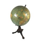
A Rare Philips slate surface Globe 63 x 48 cm.
Map of the Coalfields of Scotland printed by W & A K Johnston, features Railways and Canals


![POCKET GLOBE; FOREST, J. [Globe Terrestre.] Paris: Forest, Géographe-Éditeur, 17 Rue d...](https://portal-images.azureedge.net/auctions-2024/bonham10894/images/1d4d34d2-06f7-4c2c-a840-b15300783efc.jpg?w=155&h=155)


![[ATLAS] COLE and ROPER. Nightingale, Joseph.](https://portal-images.azureedge.net/auctions-2024/bearne10150/images/4bd431a9-b8cb-49bb-9b6a-b15000fc8b3f.jpg?w=155&h=155)