Filtered by:
- Category
- List
- Grid
A subscription to the Price Guide is required to view results for auctions ten days or older. Click here for more information
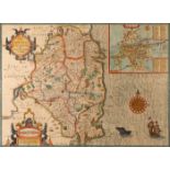

17th Century, John Speed, map of Leinster. The Countie of Leinster with the Citie Dublin Described. Early colouring. Framed. 15½ x 20½in. (39.37 x...
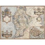
17th Century, John Speed, map of Connaught Attractive map of Connaught with inset town plan of
17th Century, John Speed, map of Connaught Attractive map of Connaught with inset town plan of Galway. “Performet by John Speede and are to be sol...
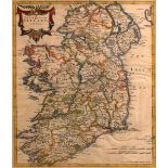
17th century map, Robert Morden, The Kingdom of Ireland. 1695, early colouring. Framed. 17 x 14½
17th century map, Robert Morden, The Kingdom of Ireland. 1695, early colouring. Framed. 17 x 14½in. (43.18 x 36.83cm)
1797 Alexander Taylor, military map of Ireland. Published by James Wild, printed on paper, contemporary hand coloured, cut and laid on linen for f...
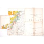
1911-1925 Maps of Ireland showing Irish speaking regions. Four Coimisiun na Gaeltachta and Local
1911-1925 Maps of Ireland showing Irish speaking regions. Four Coimisiun na Gaeltachta and Local Government Board maps showing the percentage of, ...
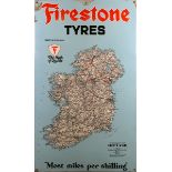
1960s Advertising road-map of Ireland, Firestone Tyres. A large rectangular enamel sign, 'Firestone Tyres' above a map of Ireland over 'Most miles...
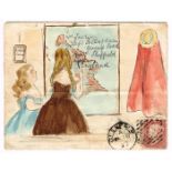
1873 hand painted illustrated envelope with penny red tied Glenealy duplex cancel. Depicting a "
1873 hand painted illustrated envelope with penny red tied Glenealy duplex cancel. Depicting a "National School" with teacher pointing out the add...