Filtered by:
- Category
- List
- Grid
This auctioneer has chosen to not publish their results. Please contact them directly for any inquiries.
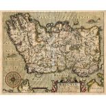

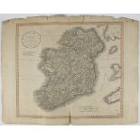
1607 Map by William Hole and Christopher Saxton, Hibernie, first edition. Handcoloured engraved
1607 Map by William Hole and Christopher Saxton, Hibernie, first edition. Handcoloured engraved map oriented to the West, large compass rose, lati...
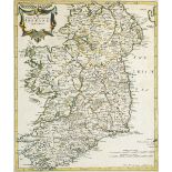
1722 Map by Robert Morden, The Kingdom of Ireland. original colouring, framed. 17 x 14½in. (43.18
1722 Map by Robert Morden, The Kingdom of Ireland. original colouring, framed. 17 x 14½in. (43.18 x 36.83cm) P ...[more]
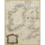
1722 Robert Morden, The Kingdom of Ireland. original colouring, framed; also A Correct Chart of
1722 Robert Morden, The Kingdom of Ireland. original colouring, framed; also A Correct Chart of St. George's Channel and the Irish Sea", after Ric...
1798 Maps of Dublin, Kildare and Wicklow. A set of three framed hand-coloured maps, published by
1798 Maps of Dublin, Kildare and Wicklow. A set of three framed hand-coloured maps, published by Laurie and Whittle. 53, Fleet Street, London, 179...
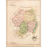
1799. A New Map of Ireland by John Cary. Published during the great Irish Rebellion. Outline colouring. A useful map of Ireland for students of th...
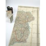
Mid 19th century, James Wyld, Geographer to the Queen, case map of Ireland. A map of the island of
Mid 19th century, James Wyld, Geographer to the Queen, case map of Ireland. A map of the island of Ireland in two halves, East & West. Handcoloure...
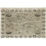
Dublin 1861, Illustrated map of the City. Published by D. Edward Heffernan, Civil Engineer. The
Dublin 1861, Illustrated map of the City. Published by D. Edward Heffernan, Civil Engineer. The engraved map of the city between the canals, with ...
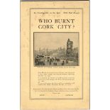
1921 Who Burnt Cork City? and Report of the Labour Commission to Ireland. Who Burnt Cork City? The
1921 Who Burnt Cork City? and Report of the Labour Commission to Ireland. Who Burnt Cork City? The Irish Labour Party and Trade Union Congress, Du...
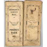
1929 Catholic Emancipation Centenary Celebration map of The Phoenix Park. An Eight Inches to One
1929 Catholic Emancipation Centenary Celebration map of The Phoenix Park. An Eight Inches to One Statute Mile, Ordnance Survey map of the Assembly...