No Image Lot 129 Venice Simplon Orient Express by Fix Masseau 'Milano', 97cm tall x 62cm. Generally good, some 129Venice Simplon Orient Express by Fix Masseau 'Milano', 97cm tall x 62cm. Generally good, some Leighton Hall Auctions Venice Simplon Orient Express by Fix Masseau 'Milano', 97cm tall x 62cm. Generally good, some folds / creases. Small losses apparent. Add to watchlist Live
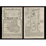
No Image Lot 387 Six various coloured maps of Norfolk, to include: Walker's map of Norfolk, 1861, marked up for fox- 387Six various coloured maps of Norfolk, to include: Walker's map of Norfolk, 1861, marked up for fox- Keys Fine Art Auctioneers Six various coloured maps of Norfolk, to include: Walker's map of Norfolk, 1861, marked up for fox-hunting districts; Walker's map of Norfolk, 183... Add to watchlist Live
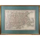
Reserve not met No Image Lot 244 NEW ENGLAND MAP. Colton's Massachusetts, Connecticut, Rhode Island. New York: G.W. & C.B. Colton... 244NEW ENGLAND MAP. Colton's Massachusetts, Connecticut, Rhode Island. New York: G.W. & C.B. Colton... Bonhams NEW ENGLAND MAP. Colton's Massachusetts, Connecticut, Rhode Island. New York: G.W. & C.B. Colton & Co., 1879. Engraved map with hand-colored bo... Add to watchlist Timed
No Image Lot 147 A Robert Morden Map of Dorsetshire, 14" x 17" centre crease (some water marks) and another map of 147A Robert Morden Map of Dorsetshire, 14" x 17" centre crease (some water marks) and another map of Bridport Auctions A Robert Morden Map of Dorsetshire, 14" x 17" centre crease (some water marks) and another map of Dorset after C & J Greenwood. Together with a c... Add to watchlist Live
No Image Lot 113 Attributed to Gabriele Koch, A large ovoid vessel with pink and black colouring, impressed 'K' mark, 113Attributed to Gabriele Koch, A large ovoid vessel with pink and black colouring, impressed 'K' mark, John Nicholson's Attributed to Gabriele Koch, A large ovoid vessel with pink and black colouring, impressed 'K' mark, 10" (25cm) high. Add to watchlist Live
Reserve not met No Image Lot 946 Original Master Trailer Reel (s) For The Film: Thunder Pass (1954) (1 Tin) 946Original Master Trailer Reel (s) For The Film: Thunder Pass (1954) (1 Tin) Excalibur Auctions Ltd Original Master Trailer Reel (s) For The Film: Thunder Pass (1954) (1 Tin) Add to watchlist Timed
Reserve not met No Image Lot 25 Original Master Trailer Reel (s) For The Film: Ambush At Cimarron Pass (1958) (1 Tin) 25Original Master Trailer Reel (s) For The Film: Ambush At Cimarron Pass (1958) (1 Tin) Excalibur Auctions Ltd Original Master Trailer Reel (s) For The Film: Ambush At Cimarron Pass (1958) (1 Tin) Add to watchlist Timed
Reserve not met No Image Lot 212 Bowen 290 Yrs Old Detailed Road Map Whitby to Durham Newcastle North East. 212Bowen 290 Yrs Old Detailed Road Map Whitby to Durham Newcastle North East. William George Title: Bowen 290 Yrs Old Detailed Road Map Whitby to Durham Newcastle North East. Description: Bowen 290 Yrs Old Detailed Road Map ... Add to watchlist Timed
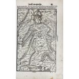
No Image Lot 918 ALLEGORICAL MAP -- (EUROPA REGINA, Queen Europe). (Basel, H. Petri, 1588). Plain allegorical 918ALLEGORICAL MAP -- (EUROPA REGINA, Queen Europe). (Basel, H. Petri, 1588). Plain allegorical Burgersdijk & Niermans ALLEGORICAL MAP -- (EUROPA REGINA, Queen Europe). (Basel, H. Petri, 1588). Plain allegorical woodcut map from S. Munster's 'Cosmographey', German ... Add to watchlist Live
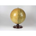
No Image Lot 693 Seltener Mondglobus von Paul Räth 693Seltener Mondglobus von Paul Räth Nosbüsch & Stucke GmbH Auktionen Berlin Seltener Mondglobus von Paul Räth. Leipzig, 1963, bezeichnet mit "Räths Mondglobus, Durchmesser 33 cm, Maßstab 1:10400000, Die Namen der Formatio... Add to watchlist Live
No Image Lot 120 Thames. Ravenstein's Oarsmen's and Anglers Map of the River Thames 120Thames. Ravenstein's Oarsmen's and Anglers Map of the River Thames Catherine Southon Auctioneers & Valuers Thames. Ravenstein's Oarsmen's and Anglers Map of the River Thames from its source to London Bridge a concertina style folding map backed on line... Add to watchlist Live
No Image Lot 123 London. Mogg's Stranger's Guide Through London and entirely New Plan. .....' 123London. Mogg's Stranger's Guide Through London and entirely New Plan. .....' Catherine Southon Auctioneers & Valuers London. Mogg's Stranger's Guide Through London and entirely New Plan. .....' steel engraved dissected folding map with hand colouring in twelve s... Add to watchlist Live
No Image Lot 122 London. Wyld's New Map of London, 1877 122London. Wyld's New Map of London, 1877 Catherine Southon Auctioneers & Valuers London. Wyld's New Map of London, 1877 London, James Wyld, 1876, an engraved dissected map in forty sections backed on linen with some colouring,... Add to watchlist Live
No Image Lot 2117 A quantity of assorted 20thC Bartholomew road maps to include Cambridge, Dorset, New Forest, Sussex, 2117A quantity of assorted 20thC Bartholomew road maps to include Cambridge, Dorset, New Forest, Sussex, Claydon Auctioneers Ltd A quantity of assorted 20thC Bartholomew road maps to include Cambridge, Dorset, New Forest, Sussex, Warwickshire, Merseyside, Norfolk, English La... Add to watchlist Live
No Image Lot 2111 Map: An 18thC map of Gloucestershire with hand colouring, titled An Accurate Map of the Counties 2111Map: An 18thC map of Gloucestershire with hand colouring, titled An Accurate Map of the Counties Claydon Auctioneers Ltd Map: An 18thC map of Gloucestershire with hand colouring, titled An Accurate Map of the Counties of Gloucester and Monmouth Divided into their Res... Add to watchlist Live
Reserve not met No Image Lot 248 Ancient Region of Palestine Charles Smith Classical 215 Antique Years Old Map. 248Ancient Region of Palestine Charles Smith Classical 215 Antique Years Old Map. William George Title: Ancient Region of Palestine Charles Smith Classical 215 Antique Years Old Map. Description: Ancient Region of Palestine Charles... Add to watchlist Timed
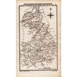
No Image Lot 2116 Maps: A quantity of assorted engraved and hand coloured maps to include Northamptonshire, 2116Maps: A quantity of assorted engraved and hand coloured maps to include Northamptonshire, Claydon Auctioneers Ltd Maps: A quantity of assorted engraved and hand coloured maps to include Northamptonshire, Nottinghamshire, Lincolnshire, Leicestershire & Rutlands... Add to watchlist Live
No Image Lot 225 China - two maps, 225China - two maps, Sworders China - two maps, comprising: 'The New Map of China', 'Prepared for Missionaries and Travellers', July 1936, sold at Kwang Hsueh Publishing, ... Add to watchlist Live
Reserve not met No Image Lot 30 ANSON, GEORGE, BARON. 1697-1762. A Voyage Around the World, in the Years MDCCXL, I, II, III, IV.... 30ANSON, GEORGE, BARON. 1697-1762. A Voyage Around the World, in the Years MDCCXL, I, II, III, IV.... Bonhams ANSON, GEORGE, BARON. 1697-1762. A Voyage Around the World, in the Years MDCCXL, I, II, III, IV. London: For the author, 1749. 4to (245 x 196 m... Add to watchlist Timed
No Image Lot 413 An etched silver Royal Geographical Society Silver Map, London assay 1976, 413An etched silver Royal Geographical Society Silver Map, London assay 1976, The Auction Centre Ltd An etched silver Royal Geographical Society Silver Map, London assay 1976, sponsors mark for John Pinches (Medallists) Ltd, housed in oak frame, a... Add to watchlist Live
No Image Lot 2121 Maps: Philips' New Scripture Atlas, to include maps and plans illustrating the historical 2121Maps: Philips' New Scripture Atlas, to include maps and plans illustrating the historical Claydon Auctioneers Ltd Maps: Philips' New Scripture Atlas, to include maps and plans illustrating the historical geography of Palestine and the Lands of the Bible, by Ge... Add to watchlist Live
No Image Lot 2110 Map: A 17thC engraved and hand coloured map of Bedfordshire after Robert Morden. Approx. 12 1/2" x 2110Map: A 17thC engraved and hand coloured map of Bedfordshire after Robert Morden. Approx. 12 1/2" x Claydon Auctioneers Ltd Map: A 17thC engraved and hand coloured map of Bedfordshire after Robert Morden. Approx. 12 1/2" x 15 1/4" Please Note - we do not make reference... Add to watchlist Live
No Image Lot 2108 Map: A 17thC engraved and hand coloured map of Scotland titled Strath-Navernia / Strath Navern after 2108Map: A 17thC engraved and hand coloured map of Scotland titled Strath-Navernia / Strath Navern after Claydon Auctioneers Ltd Map: A 17thC engraved and hand coloured map of Scotland titled Strath-Navernia / Strath Navern after Blaeu. Signed in pencil lower. Approx. 17" x ... Add to watchlist Live
No Image Lot 2106 Map: A 19thC engraved and hand coloured map of South America. Published by the Society for the 2106Map: A 19thC engraved and hand coloured map of South America. Published by the Society for the Claydon Auctioneers Ltd Map: A 19thC engraved and hand coloured map of South America. Published by the Society for the Diffusion of Useful Knowledge. Approx. 15 3/4" x 12... Add to watchlist Live
No Image Lot 2107 Map: An 18thC engraved and hand coloured map of Northamptonshire, with description of 2107Map: An 18thC engraved and hand coloured map of Northamptonshire, with description of Claydon Auctioneers Ltd Map: An 18thC engraved and hand coloured map of Northamptonshire, with description of Northamptonshire under, mounted together. Map approx. 8 1/2"... Add to watchlist Live
Reserve not met No Image Lot 252 Palestine the Holy Land The Dead Sea, Damascus, Galilee Coloured Antique Map 252Palestine the Holy Land The Dead Sea, Damascus, Galilee Coloured Antique Map William George Title: Palestine the Holy Land The Dead Sea, Damascus, Galilee Coloured Antique Map Description: Palestine the Holy Land The Dead Sea,... Add to watchlist Timed
No Image Lot 702 Seltener Marine Himmelsglobus 702Seltener Marine Himmelsglobus Nosbüsch & Stucke GmbH Auktionen Berlin Seltener Marine Himmelsglobus aus Kapitänsnachlass. London, 1920, bezeichnet "The Husun Star Globe, H. Hughes & Son LTD, London, 1920", der Globu... Add to watchlist Live
No Image Lot 121 Railwayana. Walker's A New Map of England & Wales 121Railwayana. Walker's A New Map of England & Wales Catherine Southon Auctioneers & Valuers Railwayana. Walker's A New Map of England & Wales with part of Scotland showing the Mail Coach, Turnpike & Railroads, Canals & C. a steel engrave... Add to watchlist Live
No Image Lot 2113 Three mid 20thC Hydrographic Office maritime navigational charts for Wales - South Coast, comprising 2113Three mid 20thC Hydrographic Office maritime navigational charts for Wales - South Coast, comprising Claydon Auctioneers Ltd Three mid 20thC Hydrographic Office maritime navigational charts for Wales - South Coast, comprising 1478 St Gowan's Head to St David's Head, 3274... Add to watchlist Live
No Image Lot 2120 Maps: A 20thC Map of England and Wales on two folding cloth sheets North Sheet and South Sheet, with 2120Maps: A 20thC Map of England and Wales on two folding cloth sheets North Sheet and South Sheet, with Claydon Auctioneers Ltd Maps: A 20thC Map of England and Wales on two folding cloth sheets North Sheet and South Sheet, with Index Guide to Map. Published by The Chart Pu... Add to watchlist Live
No Image Lot 2115 Map: An 18thC engraved strip map with hand colouring titled The Road from Oxford to Salisbury by 2115Map: An 18thC engraved strip map with hand colouring titled The Road from Oxford to Salisbury by Claydon Auctioneers Ltd Map: An 18thC engraved strip map with hand colouring titled The Road from Oxford to Salisbury by Thomas Gardner. Approx. 7 1/4" x 10 3/4" Please ... Add to watchlist Live
No Image Lot 2114 Map: A 19thC engraved map of West Riding, titled A Map of the North Part of the West Riding of 2114Map: A 19thC engraved map of West Riding, titled A Map of the North Part of the West Riding of Claydon Auctioneers Ltd Map: A 19thC engraved map of West Riding, titled A Map of the North Part of the West Riding of Yorkshire after John Cary. Approx. 16 1/4" x 21 1/4... Add to watchlist Live
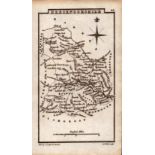
No Image Lot 2112 Map: An engraved and hand coloured map titled The Countie of Nottingham described The Shire Townes 2112Map: An engraved and hand coloured map titled The Countie of Nottingham described The Shire Townes Claydon Auctioneers Ltd Map: An engraved and hand coloured map titled The Countie of Nottingham described The Shire Townes Situation and the Earls Ther Of observed, after... Add to watchlist Live
No Image Lot 2105 Map: An 18thC engraved and hand coloured map of Buckinghamshire after Robert Morden. Approx. 8 1/ 2105Map: An 18thC engraved and hand coloured map of Buckinghamshire after Robert Morden. Approx. 8 1/ Claydon Auctioneers Ltd Map: An 18thC engraved and hand coloured map of Buckinghamshire after Robert Morden. Approx. 8 1/4" x 6 1/4" Please Note - we do not make referen... Add to watchlist Live
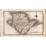
No Image Lot 2109 Map: A 19thC engraved map titled Gloucestershire from the Best Authorities, after John Cary. Approx. 2109Map: A 19thC engraved map titled Gloucestershire from the Best Authorities, after John Cary. Approx. Claydon Auctioneers Ltd Map: A 19thC engraved map titled Gloucestershire from the Best Authorities, after John Cary. Approx. 19" x 16 1/2" Please Note - we do not make r... Add to watchlist Live
No Image Lot 318 18TH CENTURY MAP OF THE KINGDOM OF IRELAND 31818TH CENTURY MAP OF THE KINGDOM OF IRELAND Sheppard's Irish Auction House divided into provinces, counties and baronies. Southern section. Showing the archbishoprics, bishoprics, cities, boroughs, market towns, villages,... Add to watchlist Live
No Image Lot 1168 Postcards, Switzerland, a good Swiss mix of over 250 cards, with 13 map cards of towns (Luzern, 1168Postcards, Switzerland, a good Swiss mix of over 250 cards, with 13 map cards of towns (Luzern, Loddon Auctions Ltd Postcards, Switzerland, a good Swiss mix of over 250 cards, with 13 map cards of towns (Luzern, Geneve), cantons, lakes etc. Also many maps of mou... Add to watchlist Live
Reserve not met No Image Lot 156 Peterborough & Longville Antique Railway Junction Diagram Map-60. 156Peterborough & Longville Antique Railway Junction Diagram Map-60. William George Title: Peterborough & Longville Antique Railway Junction Diagram Map-60. Description: Peterborough & Longville Antique Railway Junctio... Add to watchlist Timed
Reserve not met No Image Lot 211 Bowen 290 Yrs Old Detailed Road Map London-Norwich Puckeridge, Newmarket. 211Bowen 290 Yrs Old Detailed Road Map London-Norwich Puckeridge, Newmarket. William George Title: Bowen 290 Yrs Old Detailed Road Map London-Norwich Puckeridge, Newmarket. Description: Bowen 290 Yrs Old Detailed Road Map L... Add to watchlist Timed
Reserve not met No Image Lot 217 Bowen 290 Yrs Old Detailed Road Map Derbyshire High Peak Buxton Derby. 217Bowen 290 Yrs Old Detailed Road Map Derbyshire High Peak Buxton Derby. William George Title: Bowen 290 Yrs Old Detailed Road Map Derbyshire High Peak Buxton Derby. Description: Bowen 290 Yrs Old Detailed Road Map Derb... Add to watchlist Timed
Reserve not met No Image Lot 226 Bowen 290 Yrs Old Detailed Road Map Oxford Buckingham, Bedford, Cambridge. 226Bowen 290 Yrs Old Detailed Road Map Oxford Buckingham, Bedford, Cambridge. William George Title: Bowen 290 Yrs Old Detailed Road Map Oxford Buckingham, Bedford, Cambridge. Description: Bowen 290 Yrs Old Detailed Road Map ... Add to watchlist Timed
Reserve not met No Image Lot 233 Bowen 290 Yrs Old Detailed Road Map Cornwall Padstow Camleford. 233Bowen 290 Yrs Old Detailed Road Map Cornwall Padstow Camleford. William George Title: Bowen 290 Yrs Old Detailed Road Map Cornwall Padstow Camleford. Description: Bowen 290 Yrs Old Detailed Road Map Cornwall Pa... Add to watchlist Timed
Reserve not met No Image Lot 251 Antique Palestine Religious Map of Holy Land As Allotted By Joshua. 251Antique Palestine Religious Map of Holy Land As Allotted By Joshua. William George Title: Antique Palestine Religious Map of Holy Land As Allotted By Joshua. Description: Antique Palestine Religious Map of Holy Land A... Add to watchlist Timed
Reserve not met No Image Lot 255 Cambridgeshire 200 Yr Old Engraved Hand Coloured King George IV Antique Map & Text. 255Cambridgeshire 200 Yr Old Engraved Hand Coloured King George IV Antique Map & Text. William George Title: Cambridgeshire 200 Yr Old Engraved Hand Coloured King George IV Antique Map & Text. Description: Cambridgeshire Engraved Hand C... Add to watchlist Timed
Reserve not met No Image Lot 257 Hampshire 200 Yr Old Engraved Hand Coloured King George IV Antique Map & Text. 257Hampshire 200 Yr Old Engraved Hand Coloured King George IV Antique Map & Text. William George Title: Hampshire 200 Yr Old Engraved Hand Coloured King George IV Antique Map & Text. Description: Hampshire Engraved Hand Coloured Ge... Add to watchlist Timed
Reserve not met No Image Lot 267 Surrey 200 Yr Old Engraved Hand Coloured George IV Antique Map & Text. 267Surrey 200 Yr Old Engraved Hand Coloured George IV Antique Map & Text. William George Title: Surrey 200 Yr Old Engraved Hand Coloured George IV Antique Map & Text. Description: Surrey Engraved Hand Coloured George IV Ant... Add to watchlist Timed
Reserve not met No Image Lot 269 Wiltshire 200 Yr Old Engraved Hand Coloured George IV Antique Map & Text. 269Wiltshire 200 Yr Old Engraved Hand Coloured George IV Antique Map & Text. William George Title: Wiltshire 200 Yr Old Engraved Hand Coloured George IV Antique Map & Text. Description: Wiltshire Engraved Hand Coloured George ... Add to watchlist Timed
Reserve not met No Image Lot 271 Bedfordshire Antique Copper Engraved King George IV Map by Sidney Hall. 271Bedfordshire Antique Copper Engraved King George IV Map by Sidney Hall. William George Title: Bedfordshire Antique Copper Engraved King George IV Map by Sidney Hall. Description: Bedfordshire Antique Copper Engraved Georg... Add to watchlist Timed
Reserve not met No Image Lot 272 Cambridgeshire Antique Copper Engraved George IV Map by Sidney Hall. 272Cambridgeshire Antique Copper Engraved George IV Map by Sidney Hall. William George Title: Cambridgeshire Antique Copper Engraved George IV Map by Sidney Hall. Description: Cambridgeshire Antique Copper Engraved George... Add to watchlist Timed
Reserve not met No Image Lot 273 England & Wales Antique Large Coloured Detailed Copper Engraved Map. 273England & Wales Antique Large Coloured Detailed Copper Engraved Map. William George Title: England & Wales Antique Large Coloured Detailed Copper Engraved Map. Description: England & Wales Antique Large Coloured Detail... Add to watchlist Timed
Reserve not met No Image Lot 284 Wales Anglesey Antique Copper Engraved George IV Map by Sidney Hall. 284Wales Anglesey Antique Copper Engraved George IV Map by Sidney Hall. William George Title: Wales Anglesey Antique Copper Engraved George IV Map by Sidney Hall. Description: Wales Anglesey Antique Copper Engraved George... Add to watchlist Timed
Reserve not met No Image Lot 285 Wales Brecknockshire Antique Copper Engraved George IV Map by Sidney Hall. 285Wales Brecknockshire Antique Copper Engraved George IV Map by Sidney Hall. William George Title: Wales Brecknockshire Antique Copper Engraved George IV Map by Sidney Hall. Description: Wales Brecknockshire Antique Copper Eng... Add to watchlist Timed
Reserve not met No Image Lot 294 Wales Radnorshire Antique Copper Engraved George IV Map by Sidney Hall. 294Wales Radnorshire Antique Copper Engraved George IV Map by Sidney Hall. William George Title: Wales Radnorshire Antique Copper Engraved George IV Map by Sidney Hall. Description: Wales Radnorshire Antique Copper Engraved ... Add to watchlist Timed
No Image Lot 700 Erdglobus von Wagner & Debes 700Erdglobus von Wagner & Debes Nosbüsch & Stucke GmbH Auktionen Berlin Erdglobus von Wagner & Debes. Leipzig, um 1918, bezeichnet "Erd-Globus, von 96 cm Umfang, neu bearbeitet von Dr. H. Fischer, Leipzig, Wagner & De... Add to watchlist Live
No Image Lot 711 Geographie-Puzzle 711Geographie-Puzzle Nosbüsch & Stucke GmbH Auktionen Berlin Geographie-Puzzle. Frankreich, um 1860, Atlas Géographique, drei Karten von Europa, Frankreich und Holland, herausgegeben von A. Logerot, Éditeur... Add to watchlist Live
No Image Lot 128 De Bry (Theodor) IX Expurgnatio Civitatis S. Augustini In America Sitae 128De Bry (Theodor) IX Expurgnatio Civitatis S. Augustini In America Sitae Catherine Southon Auctioneers & Valuers De Bry (Theodor) IX Expurgnatio Civitatis S. Augustini In America Sitae a copper engraved map c.1600 with wash colouring, Latin text below Base... Add to watchlist Live
Reserve not met No Image Lot 245 ZATTA, ANTONIO. 1757-1797. La Pensilvania, la Nuova York, il Jersey settentrio[na]le.... Venice:... 245ZATTA, ANTONIO. 1757-1797. La Pensilvania, la Nuova York, il Jersey settentrio[na]le.... Venice:... Bonhams ZATTA, ANTONIO. 1757-1797. La Pensilvania, la Nuova York, il Jersey settentrio[na]le.... Venice: Antonio Zatta, 1778. Hand-colored engraved map... Add to watchlist Timed
No Image Lot 1163 Twin Towers, Manhattan Bridge, New York City Photo Print 1163Twin Towers, Manhattan Bridge, New York City Photo Print Morgan Auctions Manhattan, often referred to as the heart of New York City, is one of the five boroughs of New York City and is located primarily on Manhattan Isl... Add to watchlist Live
No Image Lot 273 Albert Einstein Photo Print 273Albert Einstein Photo Print Morgan Auctions Albert Einstein, born on March 14, 1879, in Ulm, in the Kingdom of Württemberg in the German Empire, was one of the most influential scientists o... Add to watchlist Live
No Image Lot 106 Of French interest: six fans with connections to France, the first a wood fan painted red with 106Of French interest: six fans with connections to France, the first a wood fan painted red with Morphets of Harrogate Of French interest: six fans with connections to France, the first a wood fan painted red with narrow fabric leaf, painted with a black cat, purch... Add to watchlist Live


![ZATTA, ANTONIO. 1757-1797. La Pensilvania, la Nuova York, il Jersey settentrio[na]le.... Venice:...](https://portal-images.azureedge.net/auctions-2024/bonham10926/images/3505b891-d55b-4d40-a8f9-b155000e2dee.jpg?w=155&h=155)


