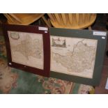
No Image Lot 525 ROBERT MORDEN: TWO HAND COLOURED ENGRAVED MAPS COMPRISING SOMERSETSHIRE AND GLOUCESTERSHIRE, 42 x 525ROBERT MORDEN: TWO HAND COLOURED ENGRAVED MAPS COMPRISING SOMERSETSHIRE AND GLOUCESTERSHIRE, 42 x JS Fine Art Auctioneers & Valuers ROBERT MORDEN: TWO HAND COLOURED ENGRAVED MAPS COMPRISING SOMERSETSHIRE AND GLOUCESTERSHIRE, 42 x 36cms and 41.5 x 34cms. (2) Add to watchlist Live
No Image Lot 738 Robert Morden - a 17th century hand coloured map o 738Robert Morden - a 17th century hand coloured map o HRD Auction Rooms Ltd Robert Morden - a 17th century hand coloured map of Dorsetshire, together with Somerset Add to watchlist Live
No Image Lot 555 Robert Morden - a 17th century hand coloured map o 555Robert Morden - a 17th century hand coloured map o HRD Auction Rooms Ltd Robert Morden - a 17th century hand coloured map of Gloucestershire, together with one of Cumberland Add to watchlist Live
No Image Lot 549 Robert Morden - a 17th century hand coloured map o 549Robert Morden - a 17th century hand coloured map o HRD Auction Rooms Ltd Robert Morden - a 17th century hand coloured map of Leicestershire, together with one other of the County of Lancaster Add to watchlist Live
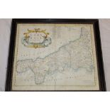
No Image Lot 537 A 17th century hand coloured map of Cornwall by Robert Morden, 537A 17th century hand coloured map of Cornwall by Robert Morden, Truro Auction Centre A 17th century hand coloured map of Cornwall by Robert Morden, framed and glazed Add to watchlist Live
No Image Lot 2110 Map: A 17thC engraved and hand coloured map of Bedfordshire after Robert Morden. Approx. 12 1/2" x 2110Map: A 17thC engraved and hand coloured map of Bedfordshire after Robert Morden. Approx. 12 1/2" x Claydon Auctioneers Ltd Map: A 17thC engraved and hand coloured map of Bedfordshire after Robert Morden. Approx. 12 1/2" x 15 1/4" Please Note - we do not make reference... Add to watchlist Live
No Image Lot 604 An 18th century hand-coloured map of Monmouth after Robert Morden 604An 18th century hand-coloured map of Monmouth after Robert Morden Truro Auction Centre An 18th century hand-coloured map of Monmouth after Robert Morden Add to watchlist Live
No Image Lot 605 An 18th century hand-coloured map of Oxfordshire after Robert Morden 605An 18th century hand-coloured map of Oxfordshire after Robert Morden Truro Auction Centre An 18th century hand-coloured map of Oxfordshire after Robert Morden Add to watchlist Live
No Image Lot 391 ROBERT MORDEN: Two coloured maps of Norfolk. c1720s. Sizes approximately: 40x60cm 391ROBERT MORDEN: Two coloured maps of Norfolk. c1720s. Sizes approximately: 40x60cm Keys Fine Art Auctioneers ROBERT MORDEN: Two coloured maps of Norfolk. c1720s. Sizes approximately: 40x60cm Add to watchlist Live
No Image Lot 416 ROBERT MORDEN: DEVONSHIRE, engraved hand coloured map circa 1753, approx 358 x 470mm, framed and 416ROBERT MORDEN: DEVONSHIRE, engraved hand coloured map circa 1753, approx 358 x 470mm, framed and Keys Fine Art Auctioneers ROBERT MORDEN: DEVONSHIRE, engraved hand coloured map circa 1753, approx 358 x 470mm, framed and glazed Add to watchlist Live
No Image Lot 358 A framed 'Somersetshire' map by Robert Morden, wat 358A framed 'Somersetshire' map by Robert Morden, wat Clarks Auction Rooms A framed 'Somersetshire' map by Robert Morden, water stain damage, twinned with 18thC. print 'Karakaooa Bay in Owhyhee' where Captain Cook was kil... Add to watchlist Live
No Image Lot 2105 Map: An 18thC engraved and hand coloured map of Buckinghamshire after Robert Morden. Approx. 8 1/ 2105Map: An 18thC engraved and hand coloured map of Buckinghamshire after Robert Morden. Approx. 8 1/ Claydon Auctioneers Ltd Map: An 18thC engraved and hand coloured map of Buckinghamshire after Robert Morden. Approx. 8 1/4" x 6 1/4" Please Note - we do not make referen... Add to watchlist Live
No Image Lot 214 After Robert Morden A map of Buckinghamshire, engraved with hand colouring, framed, 41 x 35cm 214After Robert Morden A map of Buckinghamshire, engraved with hand colouring, framed, 41 x 35cm Hansons Auctioneers and Valuers After Robert Morden A map of Buckinghamshire, engraved with hand colouring, framed, 41 x 35cm Add to watchlist Live
No Image Lot 4120 Robert Morden (British c.1650-1703): 'The North Riding of Yorkshire' 4120Robert Morden (British c.1650-1703): 'The North Riding of Yorkshire' David Duggleby Auctioneers & Valuers Robert Morden (British c.1650-1703): 'The North Riding of Yorkshire', early 18th century engraved map with hand colouring 35cm x 41cm Add to watchlist Live
No Image Lot 147 A Robert Morden Map of Dorsetshire, 14" x 17" centre crease (some water marks) and another map of 147A Robert Morden Map of Dorsetshire, 14" x 17" centre crease (some water marks) and another map of Bridport Auctions A Robert Morden Map of Dorsetshire, 14" x 17" centre crease (some water marks) and another map of Dorset after C & J Greenwood. Together with a c... Add to watchlist Live
No Image Lot 660 Robert Morden (1650-1703) hand coloured map of Hampshire, 34 x 40cm 660Robert Morden (1650-1703) hand coloured map of Hampshire, 34 x 40cm Gorringes Robert Morden (1650-1703) hand coloured map of Hampshire, 34 x 40cm Add to watchlist Live
No Image Lot 171 Various maps including The Environs of London 1832 by Baldwin, Tho Bowen England & Wales, Robert 171Various maps including The Environs of London 1832 by Baldwin, Tho Bowen England & Wales, Robert Plymouth Auction Rooms Various maps including The Environs of London 1832 by Baldwin, Tho Bowen England & Wales, Robert Morden Hampshire also Berkshire, Surrey, Essex, S... Add to watchlist Live
No Image Lot 20 Robert Morden, a map of Kent, etching later hand coloured, 13.75" x 25" (35 x 63.5cm), along with an 20Robert Morden, a map of Kent, etching later hand coloured, 13.75" x 25" (35 x 63.5cm), along with an John Nicholson's Robert Morden, a map of Kent, etching later hand coloured, 13.75" x 25" (35 x 63.5cm), along with an antique map of the area around Westerham, etc... Add to watchlist Live
No Image Lot 93 Robert Morden, a map of Kent, Circa 1700, hand coloured, 14.5" x 25.5" (37 x 65cm), along with ' 93Robert Morden, a map of Kent, Circa 1700, hand coloured, 14.5" x 25.5" (37 x 65cm), along with ' John Nicholson's Robert Morden, a map of Kent, Circa 1700, hand coloured, 14.5" x 25.5" (37 x 65cm), along with 'Tunbridge Wells humbly Dedicated to Thomas Pellet... Add to watchlist Live