No Image Lot 140 H.C CAREY AND I.LEA (publishers) A Complete Historical, Chronological and Geographical AMERICAN 140H.C CAREY AND I.LEA (publishers) A Complete Historical, Chronological and Geographical AMERICAN Adams H.C CAREY AND I.LEA (publishers) A Complete Historical, Chronological and Geographical AMERICAN ATLAS being a Guide to the History of NORTH and... Add to watchlist Live
No Image Lot 526 GERARD MERCATOR MAP OF IRELAND 526GERARD MERCATOR MAP OF IRELAND Sheppard's Irish Auction House MERCATOR, Gerard (1512-94). Irlandiae regnum. [Amsterdam: c.1609 or later]. Engraved map of Ireland, Provenance: West Cork Private Collection. Ima... Add to watchlist Live
No Image Lot 370 17TH-CENTURY MAP OF STOCKHOLM 37017TH-CENTURY MAP OF STOCKHOLM Sheppard's Irish Auction House Topographia Insulae Huenae in Celebri Porthmo Regni Daniae, quem vulgo Oersunt uocant. Framed. Image size: 34 x 48 cm.; framed: 44 x 60 cm. CARTOG... Add to watchlist Live
No Image Lot 203 19TH-CENTURY ESTATE MAP 20319TH-CENTURY ESTATE MAP Sheppard's Irish Auction House Ard na Crusha in the county of Cork. Part of the estate of Major Townsend. Published 1846. Provenance: West Cork Private Collection. IRISH HISTOR... Add to watchlist Live
No Image Lot 202 19TH-CENTURY ESTATE MAP 20219TH-CENTURY ESTATE MAP Sheppard's Irish Auction House Bally Macororan in the county of Cork. Part of the estate of Major Townsend. Published 1846. Provenance: West Cork Private Collection. IRISH HIST... Add to watchlist Live
No Image Lot 318 18TH CENTURY MAP OF THE KINGDOM OF IRELAND 31818TH CENTURY MAP OF THE KINGDOM OF IRELAND Sheppard's Irish Auction House divided into provinces, counties and baronies. Southern section. Showing the archbishoprics, bishoprics, cities, boroughs, market towns, villages,... Add to watchlist Live
No Image Lot 200 THE TOWNLAND OF LONAGH 200THE TOWNLAND OF LONAGH Sheppard's Irish Auction House 19th-century estate map. Situated in the Parish of Island, County of Cork. Dated 1846. Part of the estate of Major Townsend. Published 1846. Prove... Add to watchlist Live
No Image Lot 1371 LARGE 19TH-CENTURY NATIONAL SCHOOL MAP 1371LARGE 19TH-CENTURY NATIONAL SCHOOL MAP Sheppard's Irish Auction House of Ireland. (Irish Vernacular) 161 x 128 cm. VERNACULAR Friday 3rd May 2024 10:37:24 Add to watchlist Live
No Image Lot 199 JOHN SPEEDE (1552 - 1629) North Hamptonshire, uncoloured, engraved by Hondius 1610, 199JOHN SPEEDE (1552 - 1629) North Hamptonshire, uncoloured, engraved by Hondius 1610, Adams JOHN SPEEDE (1552 - 1629) North Hamptonshire, uncoloured, engraved by Hondius 1610, from the atlas. 37 x 51cm Add to watchlist Live
No Image Lot 779 World Globe on wooden stand. {45 cm H x 33 cm Dia.}. 779World Globe on wooden stand. {45 cm H x 33 cm Dia.}. Victor Mee Auctions Ltd World Globe on wooden stand. {45 cm H x 33 cm Dia.}. Add to watchlist Live
No Image Lot 93 A FOURTY-EIGHT STAR AMERICA FLAG, EARLY 20TH CENTURY dyed linen laid down on board, 93A FOURTY-EIGHT STAR AMERICA FLAG, EARLY 20TH CENTURY dyed linen laid down on board, Adams A FOURTY-EIGHT STAR AMERICA FLAG, EARLY 20TH CENTURY dyed linen laid down on board, framed Provenance: Dawesfield House, Montgomery County, ... Add to watchlist Live
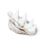
No Image Lot 21 AN INDO-PACIFIC OCEAN CLAMSHELL 21AN INDO-PACIFIC OCEAN CLAMSHELL Adams AN INDO-PACIFIC OCEAN CLAMSHELL (Tridacna Gigis) 51cm wide Add to watchlist Live
No Image Lot 26 Postcards - County Cork, a collection of Postcards which includes Drake's Pool, Crosshaven; 26Postcards - County Cork, a collection of Postcards which includes Drake's Pool, Crosshaven; Purcell Auctioneers Postcards - County Cork, a collection of Postcards which includes Drake's Pool, Crosshaven; Blarney Castle, Co. Cork; View From Tunnel; Road, Glen... Add to watchlist Live