


FOLIO SOCIETY, Limited Edition: QUEEN MARY ATLAS. Two Volumes. Folio Society, 2005. Limited Edition No. 581 of 1000 . Folio, Bound in full c...
70 item(s)
Filtered by:
- Primary Category,
- Item Type
- List
- Grid
-
70 item(s)/page
![[ATLAS] COLE and ROPER. Nightingale, Joseph.](https://portal-images.azureedge.net/auctions-2024/bearne10150/images/4bd431a9-b8cb-49bb-9b6a-b15000fc8b3f.jpg?w=155&h=155)
[ATLAS] COLE and ROPER. Nightingale, Joseph. English Topography: or, a series of … Counties of England and Wales. Accompanied by a Map of each Cou...
![CHATELAIN, HENRI. 1684-1743. Carte De La Nouvelle France.... [Amsterdam: 1719.]](https://portal-images.azureedge.net/auctions-2024/bonham10926/images/184d5f4b-af1d-466b-9196-b155000e2273.jpg?w=155&h=155)
CHATELAIN, HENRI. 1684-1743. Carte De La Nouvelle France.... [Amsterdam: 1719.] Hand-colored engraved map, 420 x 490 mm. Matted and framed. Not...

Lot 140
H.C CAREY AND I.LEA (publishers) A Complete Historical, Chronological and Geographical AMERICAN
H.C CAREY AND I.LEA (publishers) A Complete Historical, Chronological and Geographical AMERICAN ATLAS being a Guide to the History of NORTH and...

Title: Ancient Region of Palestine Charles Smith Classical 215 Antique Years Old Map. Description: Ancient Region of Palestine Charles...
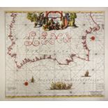
SPAIN -- "HISPANIÆ, et Portugalliæ Maritimi tractus, à S. Andreo, ad Malagam/Pascaert van Spangie, en Portugal". (Amst., L. Renard, 1715). Handcol...

Lot 415
WILLEM JANSSON BLAEU (1571 - 1638): 17th century (c1635) engraved coloured map of Lake Geneva
WILLEM JANSSON BLAEU (1571 - 1638): 17th century (c1635) engraved coloured map of Lake Geneva after J Coulart from an early edition of Blaeu's ATL...
![[ATLAS] BELL, WilIam.](https://portal-images.azureedge.net/auctions-2024/bearne10150/images/5f19849a-3249-4645-8396-b15000fc8ac4.jpg?w=155&h=155)
Lot 325
[ATLAS] BELL, WilIam.
[ATLAS] BELL, WilIam. A New General Atlas … principal countries in ...
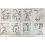
Maps: A quantity of assorted engraved and hand coloured maps to include Northamptonshire, Nottinghamshire, Lincolnshire, Leicestershire & Rutlands...

Lot 63
Qty 1880's maps of area's to South End of Wisbech showing land division and 2 antique Atlas' 1906
Qty 1880's maps of area's to South End of Wisbech showing land division and 2 antique Atlas' 1906 and 1922

Maps: Philips' New Scripture Atlas, to include maps and plans illustrating the historical geography of Palestine and the Lands of the Bible, by Ge...

Title: Palestine the Holy Land The Dead Sea, Damascus, Galilee Coloured Antique Map Description: Palestine the Holy Land The Dead Sea,...

Title: Westminster Camden Chelsea Wandsworth Kensington London Antique Map. Description: Westminster Camden Chelsea Wandsworth Kensing...
LOW COUNTRIES -- COLLECTION of 11 plain in-text engr. maps by A. Goos and P. Kaerius, incl. some text-lvs. (pp. 333-416), from a Mercator-Hondius-...

Lot 383
Five mixed maps, to include: J Bartholomew coloured engraved map, 'The Wash' from Survey Atlas 1903,
Five mixed maps, to include: J Bartholomew coloured engraved map, 'The Wash' from Survey Atlas 1903, Section XXII, Plate 33; Benjamin Baker half m...

Lot 349
HERTFORDSHIRE.
HERTFORDSHIRE. Speed, John, Hartford Shire Described, a hand coloured engraved county map, Sudbury & Humbe (1611 edn. or later), foxed overall, 38...
Lot 360
SHARPE, John (publisher).
SHARPE, John (publisher). [Sharpe's Corresponding Atlas], Chapman & Hall circa 1847, lacking title and preliminaries, 19 maps (only, of 54), some ...

JOHN SPEEDE (1552 - 1629) North Hamptonshire, uncoloured, engraved by Hondius 1610, from the atlas. 37 x 51cm

Title: Antique Palestine Religious Map of Holy Land As Allotted By Joshua. Description: Antique Palestine Religious Map of Holy Land A...
SOUTH AMERICA -- COLLECTION of 20 handcold. maps/plan from "Le Petit Atlas Maritime Recueil De Cartes et Plans Des Quatre Parties Du Monde" by J.N...

Lot 388
Eight various coloured maps of Norfolk, to include: Kelly's map of Norfolk, c1900; Weller's map of
Eight various coloured maps of Norfolk, to include: Kelly's map of Norfolk, c1900; Weller's map of Norfolk 1862; E Weller's map of Norfolk for Phi...

Lot 387
Six various coloured maps of Norfolk, to include: Walker's map of Norfolk, 1861, marked up for fox-
Six various coloured maps of Norfolk, to include: Walker's map of Norfolk, 1861, marked up for fox-hunting districts; Walker's map of Norfolk, 183...
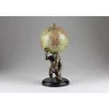
Erdglobus mit Atlas-Figur vom Columbus-Verlag. Berlin, um 1925, bezeichnet "Schüler-Globus, Columbus-Verlag G.M.B.H. Berlin-Lichterfelde", der Gl...
Lot 711
Geographie-Puzzle
Geographie-Puzzle. Frankreich, um 1860, Atlas Géographique, drei Karten von Europa, Frankreich und Holland, herausgegeben von A. Logerot, Éditeur...
Lot 216
BUTLER, Samuel, An Atlas of Antient Geography, A New Edition, Re-Engraved, With Corrections,
BUTLER, Samuel, An Atlas of Antient Geography, A New Edition, Re-Engraved, With Corrections, Edited by the Author's Son, Longman, Brown, Green, an...
Lot 247
CONNECTICUT AREA MAPS. A group of two maps of Farmington and Plainville, from Atlas of Hartford ...
CONNECTICUT AREA MAPS. A group of two maps of Farmington and Plainville, from Atlas of Hartford and Tolland Counties, Connecticut , F.W. Beers, 1...

Title: County of Carlow Ireland Antique Detailed Coloured Victorian Map. Description: County of Carlow Ireland Antique Detailed Colour...

Title: County Of Leitrim Ireland Antique Detailed Coloured Victorian Map. Description: County Of Leitrim Ireland Antique Detailed Colo...
Title: County Of Londonderry Ireland Antique Detailed Coloured Victorian Map. Description: County Of Londonderry Ireland Antique Detai...

Title: County Of Louth Ireland Antique Detailed Coloured Victorian Map. Description: County Of Louth Ireland Antique Detailed Coloured...
Title: County Of Monaghan Ireland Antique Detailed Coloured Victorian Map. Description: County Of Monaghan Ireland Antique Detailed ...

Title: County Of Sligo Ireland Antique Detailed Coloured Victorian Map. Description: County Of Sligo Ireland Antique Detailed Coloured...

Title: County Of Waterford Ireland Antique Detailed Coloured Victorian Map. Description: County Of Waterford Ireland Antique Detailed ...

Title: Britannia Britain Smith’s Coloured Classical 115 Years Old Map. Description: Britannia Britain Smith’s Coloured Classical 115...

Title: Libyae, vel Africae Libya & North Africa Charles Smith Classical Antique Map 1809 Description: Libyae, vel Africae Libya & Nort...

Title: Macedonia et Teracia Charles Smith’s Classical 215 Years Antique Map Description: Macedonia et Teracia Charles Smith’s Classic...

Title: County of Armagh Ireland Antique Detailed Coloured Victorian Map. Description: County of Armagh Ireland Antique Detailed Colour...

Title: Collection 15 WW1 Harmsworth Atlas Antique Map 1922. Description: Collection 15 WW1 Harmsworth Atlas Antique Map 1922. Thi...

Lot 19
Emery Walker Limited (20th Century). A Collection of Sexton's Atlas of England and Wales (not
Emery Walker Limited (20th Century). A Collection of Sexton's Atlas of England and Wales (not complete), with index, primary tables and frontispie...

Lot 58451
Atlas Homannianarum
Atlas Homannianarum Auswahlatlas mit 36 Seiten Einleitung "Anfangsgründe der Geographie" und 40 Karten im Verlagskolorit, dabei die große Weltkart...

Lot 100
A MAP OF CHINA PUBLISHED BY D'ANVILLE IN HIS ATLAS NOUVELLE ATLAS DE CHINE, PARIS, CIRCA 1730
ink and colour on paper, framed and glazed, image 62 by 53cm Footnote: In 1708-1716, the Kangxi emperor ordered a surveying of China. A copy of th...

Title: North & East Riding Yorkshire 1895 Antique Victorian Coloured Map. Description: North & East Riding Yorkshire 1895 Antique Vict...

Title: The Isle of Man 1895 Antique Victorian Coloured Map. Description: The Isle of Man 1895 Antique Victorian Coloured Map. This ...

Title: Lancashire North 1895 Antique Victorian Detailed Coloured Map. Description: Lancashire North 1895 Antique Victorian Coloured Ma...

Title: Environs Liverpool & Manchester 1895 Antique Victorian Coloured Map. Description: Environs Liverpool & Manchester 1895 Antiqu...

Title: Lake District & Cumbria 1895 Antique Victorian Coloured Map. Description: Lake District & Cumbria 1895 Antique Victorian Colour...

Title: County Cheshire 1895 Antique Victorian Detailed Coloured Map. Description: County Cheshire 1895 Antique Victorian Coloured Map....

Title: County Northumberland 1895 Antique Victorian Coloured Map. Description: County Northumberland 1895 Antique Victorian Coloure...

Title: County Durham 1895 Antique Victorian Detailed Coloured Map. Description: County Durham 1895 Antique Victorian Coloured Map. ...

Title: Counties of North Wales 1895 Antique Victorian Coloured Map. Description: Counties of North Wales 1895 Antique Victorian Colour...

Title: Counties of South Wales 1895 Antique Victorian Coloured Map. Description: Counties of South Wales 1895 Antique Victorian Colour...

Title: County Cambridgeshire 1895 Antique Victorian Coloured Map. Description: County Cambridgeshire 1895 Antique Victorian Coloured M...

Title: County Kent 1895 Antique Victorian Coloured Map. Description: County Kent 1895 Antique Victorian Coloured Map. This Coloured...

Title: The Channel Islands 1895 Antique Victorian Coloured Map. Description: The Channel Islands 1895 Antique Victorian Coloured Map. ...

Title: County Leicestershire 1895 Antique Victorian Coloured Map. Description: County Leicestershire 1895 Antique Victorian Coloured M...

Title: County Lincolnshire 1895 Antique Victorian Coloured Map. Description: County Lincolnshire 1895 Antique Victorian Coloured Map. ...

Title: County Middlesex & London 1895 Antique Victorian Coloured Map. Description: County Middlesex 1895 Antique Victorian Coloured M...

Title: County Monmouthshire 1895 Antique Victorian Coloured Map. Description: County Monmouthshire 1895 Antique Victorian Coloured Map...

Title: County Norfolk 1895 Antique Victorian Coloured Map. Description: County Norfolk 1895 Antique Victorian Coloured Map. This Co...

Title: County of Bedfordshire 1895 Antique Victorian Coloured Map. Description: County of Bedfordshire 1895 Antique Victorian Colour...