Filtered by:
- Category
- List
- Grid
A subscription to the Price Guide is required to view results for auctions ten days or older. Click here for more information
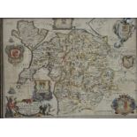

Richard Blome (1635-1705) - A General Map of North Wales, hand coloured engraved map, 34.5 x 47cm
Richard Blome (1635-1705) - A General Map of North Wales, hand coloured engraved map, 34.5 x 47cm approx sheet size, in black and gilt frame
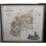
A 19th century map of Gloucestershire by C & J Greenwood dated 1831, 62 x 70cm approx, together with
A 19th century map of Gloucestershire by C & J Greenwood dated 1831, 62 x 70cm approx, together with a map of Derbyshire by Robert Morden, 40 x 45...
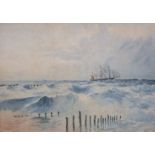
H H Steeple (late 19th century British school) - Coastal scene with sailing ship and steam boat on
H H Steeple (late 19th century British school) - Coastal scene with sailing ship and steam boat on rough sea, watercolour on paper, signed, dated ...

A 19th century engraved map showing the southern part of the North Sea, by AG Findlay, published
A 19th century engraved map showing the southern part of the North Sea, by AG Findlay, published by RH Laurie, 1883, 112 x 152cm (incomplete) toge...
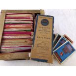
A box containing a quantity of mixed Ordnance Survey maps including examples by Bartholomew's
A box containing a quantity of mixed Ordnance Survey maps including examples by Bartholomew's