Filtered by:
- Category
3 items
- List
- Grid
A subscription to the Price Guide is required to view results for auctions ten days or older. Click here for more information
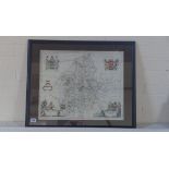

Lot 154
Johannes Bleau - 1596-1673 - Staffordiensis Comitatus, Map of Staffordshire c.1645 with hand
Johannes Bleau - 1596-1673 - Staffordiensis Comitatus, Map of Staffordshire c.1645 with hand colouring 42 x 51 cm. Frame size 55 x 67 cm. Generall...
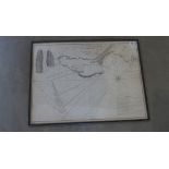
Lot 168
A Nautical Chart of The isle Road and Race of Portland with the Shambles originally printed in
A Nautical Chart of The isle Road and Race of Portland with the Shambles originally printed in 1779 for Robt Sayer and John Bennett in an ebonised...
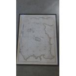
Lot 169
A Nautical Chart of the Islands of Jersey and Guernsey Sark Herm and Alderney with the adjacent
A Nautical Chart of the Islands of Jersey and Guernsey Sark Herm and Alderney with the adjacent Coast of France by LS De la Rochette originally pr...