Filtered by:
- Category
- List
- Grid
A subscription to the Price Guide is required to view results for auctions ten days or older. Click here for more information
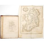

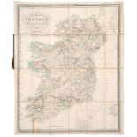
Newenham, Thomas. A View of the Natural, Political and Commercial Circumstances of Ireland. T.
Newenham, Thomas. A View of the Natural, Political and Commercial Circumstances of Ireland. T. Cadell and W. Davies, London, 1809, 4to, xxix, [ii]...
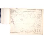
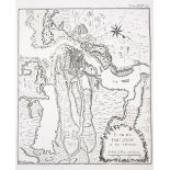
Beechey, Captain FW, et al. Report of the Merits of the Western Harbours of Ireland. Copy of the
Beechey, Captain FW, et al. Report of the Merits of the Western Harbours of Ireland. Copy of the Report and the Evidence taken before the Commissi...
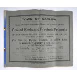
1914 Town of Carlow, Auction of Ground Rents and Freehold Property. A large auctioneer's brochure
1914 Town of Carlow, Auction of Ground Rents and Freehold Property. A large auctioneer's brochure for a public auction of ground rents and freehol...
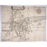
1610 Plan of the City of Dublin. An engraved map of the city of Dublin after John Speed, published
1610 Plan of the City of Dublin. An engraved map of the city of Dublin after John Speed, published as a fold-out map in Harris, Walter, `The Histo...
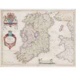
1632 Map of Ireland by Mercator. A pair of maps from the Cloppenburg edition of the Mercator Minor
1632 Map of Ireland by Mercator. A pair of maps from the Cloppenburg edition of the Mercator Minor atlas, Antwerp,1632. The Northern half of the C...
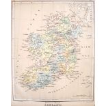
17th Century map of Ireland by Blaeu. A hand-coloured, engraved map, Hiberno Regnum vulgo Ireland.
17th Century map of Ireland by Blaeu. A hand-coloured, engraved map, Hiberno Regnum vulgo Ireland. Framed. 16.50 by 21in. (41.9 by 53.3cm) ...[m...
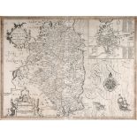
17th century map of Leinster by John Speed and a 1665 map of Les Isles Britanniques by Nicolas
17th century map of Leinster by John Speed and a 1665 map of Les Isles Britanniques by Nicolas Sanson. An engraved map, 1676, after Speed, 'The Co...
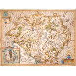
Early 17th century, map of Ulster by John Speed. John Speed 17th Century engraved and hand-coloured map of the province of Ulster with an inset ob...
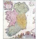
1720, Map of Ireland by Johann Baptiste Homann. A hand-coloured, engraved map of Ireland, 'Hiberniae
1720, Map of Ireland by Johann Baptiste Homann. A hand-coloured, engraved map of Ireland, 'Hiberniae Regnum tam in praecipuas, Ultoniae, Connaciae...
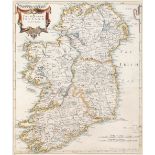
1722 The Kingdom of Ireland, by Robert Morden. A hand coloured engraved map, this edition with Newry
1722 The Kingdom of Ireland, by Robert Morden. A hand coloured engraved map, this edition with Newry spelt correctly. Framed. 17 by 14in. (43.2 by...
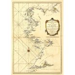
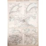
18th century, Map of Ireland by Richard W Seale, two charts and plans of the principle towns,
18th century, Map of Ireland by Richard W Seale, two charts and plans of the principle towns, forts and harbours. c1766: Dublin to Londonderry cha...
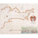
1794: Huddart Hydrographical Survey of the West Coast of Ireland A hand-coloured, engraved map, A
1794: Huddart Hydrographical Survey of the West Coast of Ireland A hand-coloured, engraved map, A new hydrographical survey of the West Coast of I...
1835 Map of Ireland by James Palmer. A hand-coloured, engraved map of Ireland, A New and Improved
1835 Map of Ireland by James Palmer. A hand-coloured, engraved map of Ireland, A New and Improved Map of Ireland Exhibiting the Mail Coach and Tur...
1837 Lewis's Atlas and Gems of the Killarney Lakes. Lewis's Atlas Comprising the Counties of Ireland
1837 Lewis's Atlas and Gems of the Killarney Lakes. Lewis's Atlas Comprising the Counties of Ireland and a General Map of the Kingdom, London, 18...
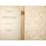
1837 Municipal Corporation Boundries (Ireland), Reports and Plans. Ordered by the House of Commons, to be printed, 10 May 1837, folio, hand-colour...
1840-1911 Maps of Ireland, by Lizars and Bacon. A hand-coloured map of Ireland in two sheets by
1840-1911 Maps of Ireland, by Lizars and Bacon. A hand-coloured map of Ireland in two sheets by Lizars, Edinburgh; together with a colour printed ...
1880 Maps of Ireland. Physical and Political Maps of Ireland. as published in W. Swan Sonnenschein &
1880 Maps of Ireland. Physical and Political Maps of Ireland. as published in W. Swan Sonnenschein & Allen's Plastic School Atlas. (3) 12 by 10in....
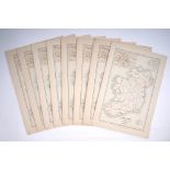
1882 Bevan, George Phillips, eight maps of Ireland from his Statistical Atlas. A series of colour
1882 Bevan, George Phillips, eight maps of Ireland from his Statistical Atlas. A series of colour printed maps of Ireland to illustrate, the Railw...
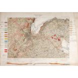
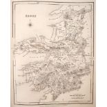
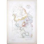
1904 Map of Belfast, Geological Survey of Ireland. Ordnance Survey Office, Southampton, 1904. A
1904 Map of Belfast, Geological Survey of Ireland. Ordnance Survey Office, Southampton, 1904. A coloured lithograph map of the environs of Belfast...
1911-1925 Coimisiún na Gaeltachta, Maps of Ireland showing Irish speaking regions. Two Coimisiún
1911-1925 Coimisiún na Gaeltachta, Maps of Ireland showing Irish speaking regions. Two Coimisiún na Gaeltachta and Local Government Board maps, ea...
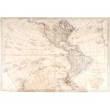
1774 Map of the Western Hemisphere showing America North and South by Samuel Dunn. An outline-
1774 Map of the Western Hemisphere showing America North and South by Samuel Dunn. An outline-coloured, engraved map, America North and South wit...
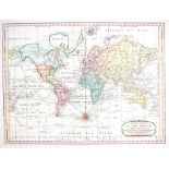
1789 Chart of the World, by Samuel Dunn. A hand-coloured, engraved chart, 'on Mercator's Projection with the tracks and discoveries of the Latest ...
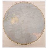
Circa 1800. Map of the Southern Hemisphere. A hand-coloured, engraved map, Prospective Projection of
Circa 1800. Map of the Southern Hemisphere. A hand-coloured, engraved map, Prospective Projection of the Southern Hemisphere, on the Plane of the ...
1776 Maps of Long Island and Boston during the American Revolutionary War. Two hand-coloured,
1776 Maps of Long Island and Boston during the American Revolutionary War. Two hand-coloured, engraved maps, the map of Long Island showing the po...
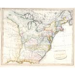
1804 Map of the United States of America. A hand-coloured, engraved map of the Eastern half of North
1804 Map of the United States of America. A hand-coloured, engraved map of the Eastern half of North America. by E Patteson, the colouring contemp...
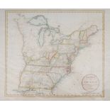
1811 Map of States of America by John Russell. A hand-coloured, engraved maps, States of America,
1811 Map of States of America by John Russell. A hand-coloured, engraved maps, States of America, drawn from the best authorities, by John Russell...
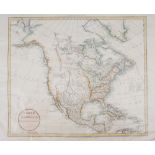
1811 Map of North America by John Russell. A hand-coloured, engraved maps, North America, drawn from
1811 Map of North America by John Russell. A hand-coloured, engraved maps, North America, drawn from the best authorities, by John Russell, publis...
Mid 19th century map of The United States of North America, by JW Lowry. An outline-coloured,
Mid 19th century map of The United States of North America, by JW Lowry. An outline-coloured, engraved map, published by Blackie and Son. Unframed...
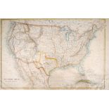
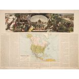
Circa 1855 Illustrated maps of North America, the United States and Mexico, California and Texas.
Circa 1855 Illustrated maps of North America, the United States and Mexico, California and Texas. Three hand-coloured, engraved maps drawn and en...
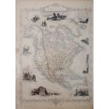
1877 Map of North America by JP Morales. A hand-coloured printed map of America, America del
1877 Map of North America by JP Morales. A hand-coloured printed map of America, America del Norte, with large decorative panorama showing fur-tra...

Late 19th century plans of Boston. Two lithographic maps of the City of Boston, a coloured map, c.
Late 19th century plans of Boston. Two lithographic maps of the City of Boston, a coloured map, c. 1893, 'Showing Freight and Passenger Depots, Gr...
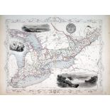
Circa 1855 Illustrated maps of West Canada, Newfoundland and Nova Scotia; British America; and
Circa 1855 Illustrated maps of West Canada, Newfoundland and Nova Scotia; British America; and East Canada and New Brunswick. Four outline-colour...
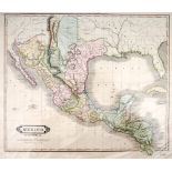
Early 19th century map of Mexico and Guatemala. A hand-coloured, engraved map of Mexico before the
Early 19th century map of Mexico and Guatemala. A hand-coloured, engraved map of Mexico before the Republic of Texas, showing the southern United ...
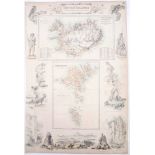
Circa 1865. Maps of the Danish Islands in the North Atlantic Ocean. Hand-coloured engraved maps
Circa 1865. Maps of the Danish Islands in the North Atlantic Ocean. Hand-coloured engraved maps surrounded by pictures of the local people, animal...
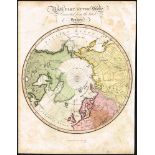
1829 Polar map of the Northern Hemisphere. A hand coloured, engraved map, North Part of the Globe
1829 Polar map of the Northern Hemisphere. A hand coloured, engraved map, North Part of the Globe Corrected from the Latest Voyages, Fisher, Son &...
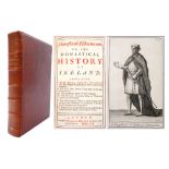
Alemand, Louis Augustin. Monasticon Hibernicum or The Monastical History of Ireland. William
Alemand, Louis Augustin. Monasticon Hibernicum or The Monastical History of Ireland. William Mears, London, 1722, 8vo, xiv, 416pp index, folding m...
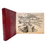
Gwynn, Stephen. Highways and Byways in Donegal and Antrim. Macmillan, London, 1903. 8vo, 314pp. with
Gwynn, Stephen. Highways and Byways in Donegal and Antrim. Macmillan, London, 1903. 8vo, 314pp. with fold out map, many illustrations by Hugh Thom...
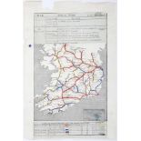
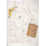
1948 (March 2) Railway axle-weight map of Ireland. An axle-weight map of the railway network of
1948 (March 2) Railway axle-weight map of Ireland. An axle-weight map of the railway network of Ireland. the lines colour-coded according to the w...