Refine your search
Estimate
Category
- Arms, Armour & Militaria (121)
- Coins (114)
- Collectables (51)
- Books & Periodicals (48)
- Bank notes (41)
- Prints (36)
- Maps (27)
- Silver & Silver-plated items (17)
- Ceramics (14)
- Sculpture (13)
- Sporting Memorabilia & Equipment (10)
- Ethnographica & Tribal Art (8)
- Jewellery (7)
- Models, Toys, Dolls & Games (5)
- Drawings & Pastels (4)
- Oil, Acrylic paintings & Mixed Media (4)
- Photographs (4)
- Classic Cars, Motorcycles & Automobilia (3)
- Glassware (3)
- Furniture (2)
- Metalware (2)
- Stamps (2)
- Textiles (2)
- Watches & Watch accessories (2)
- Clocks (1)
- Entertainment Memorabilia (1)
- Kitchenalia (1)
- Scientific Instruments (1)
- Vintage Fashion (1)
- List
- Grid
A subscription to the Price Guide is required to view results for auctions ten days or older. Click here for more information

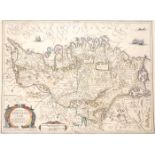
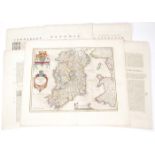
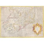
1632 Map of Leinster by John Speed. A hand-coloured, engraved map, 'The Countie of Leinster with the
1632 Map of Leinster by John Speed. A hand-coloured, engraved map, 'The Countie of Leinster with the Citie Dublin Described', printed by John Daws...
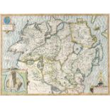
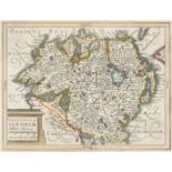
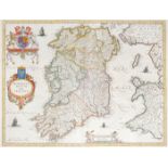
Early 17th century, map of Ulster by John Speed. John Speed 17th Century engraved and hand-coloured map of the province of Ulster with an inset ob...
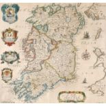
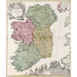
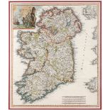
1646 Map of Ireland, by Joannes Jansson. A hand-coloured engraved map, `Hibernia Regnum Vulgo Ireland`, based on Speed`s earlier work, as publishe...
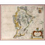
1646 Map of Connaught, by Joannes Jansson. A hand-coloured engraved map, `Provincia Connachtiae -
1646 Map of Connaught, by Joannes Jansson. A hand-coloured engraved map, `Provincia Connachtiae - The Province of Connaugt`, based on Speed`s earl...
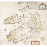
1654 Maps of Ireland by Joan Blaeu, from Theatrum or Novus Atlas. A set of six hand-coloured, engraved maps of Ireland, Ulster; Munster, Connaught...
1654 Map of Connaught by Joan Bleau. A hand-coloured, engraved map of 'Connachtia Vulgo Connaughty',
1654 Map of Connaught by Joan Bleau. A hand-coloured, engraved map of 'Connachtia Vulgo Connaughty', in the first state, as published in the 1654 ...
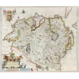
1654 Map of Ulster, by Joan Blaeu. A hand-coloured, engraved map of 'Vultonia; Hibernis Cujgujlly;
1654 Map of Ulster, by Joan Blaeu. A hand-coloured, engraved map of 'Vultonia; Hibernis Cujgujlly; Anglis Vlster', in the first state as published...
1654 Map of Ulster, by Joan Blaeu. A hand-coloured, engraved map of 'Vultonia; Hibernis Cujgujlly;
1654 Map of Ulster, by Joan Blaeu. A hand-coloured, engraved map of 'Vultonia; Hibernis Cujgujlly; Anglis Vlster', in the first state as published...
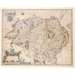
1654 Map of Leinster by Joan Blaeu. A hand-coloured, engraved map Leinster, in the first state as
1654 Map of Leinster by Joan Blaeu. A hand-coloured, engraved map Leinster, in the first state as published in the 1654 fifth volume of Novus Atla...
Mid 17th century maps of Leinster and Ulster, after Mercator. Maps of Leinster and Ulster from the
Mid 17th century maps of Leinster and Ulster, after Mercator. Maps of Leinster and Ulster from the Mercator Hondius “Atlas Minor” published in Ams...
17th Century Map. Mercator, Gerhardt. Irlandiae Regnum. c1620. South sheet, later coloured. Unframed. 13¼ x 18½in. (33.66 x 46.99cm)
17th century, Hiberniae, Map of Ireland by William Camden and a city plan of Limerick. Hiberniae
17th century, Hiberniae, Map of Ireland by William Camden and a city plan of Limerick. Hiberniae Ireland Anglis Yvrndon Britannis Erin incolis... ...
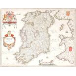
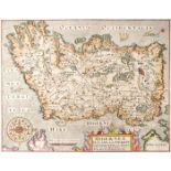
1662 Map of Ireland by Joan Blaeu A hand-coloured, engraved map of Ireland, in the second state as
1662 Map of Ireland by Joan Blaeu A hand-coloured, engraved map of Ireland, in the second state as published in Atlas Mayor, 1662, Latin edition, ...
Late 17th century, map of The Kingdom of Ireland by Robert Morden. A hand-coloured engraving,
Late 17th century, map of The Kingdom of Ireland by Robert Morden. A hand-coloured engraving, inscribed in the plate, 'Sold by Abel Swale Awnsham ...
1695 The Kingdom of Ireland, by Robert Morden. A hand-coloured, engraved map, from Camden's Britannia, 1695, with Newry spelt 'Nury' reverse blank...
Late 17th century, map of Ireland A hand-coloured engraving, 'A Mapp of the Kingdome of Ireland',
Late 17th century, map of Ireland A hand-coloured engraving, 'A Mapp of the Kingdome of Ireland', first published in 'Britannia, or a Geographical...
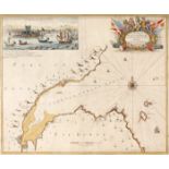
Late 17th century, chart of Carrickfergus Lough. Hand-coloured engraving by Captain Greville Collins
Late 17th century, chart of Carrickfergus Lough. Hand-coloured engraving by Captain Greville Collins with dedication to William III in a martial c...
1693 Charts of St. George's Channel and Carlingford Lough by Greenville Collins. Hand coloured ,
1693 Charts of St. George's Channel and Carlingford Lough by Greenville Collins. Hand coloured , engraved charts, as published in Great Britain's ...
17th and 18th century, Yorkshire, Schenk and Valk map and Greenvile Collins sea chart. Collins (
17th and 18th century, Yorkshire, Schenk and Valk map and Greenvile Collins sea chart. Collins (Greenvile) Burlington Bay, Scarbrough & Hartlepool...
1695 The Kingdom of Ireland, by Robert Morden. A hand-coloured, engraved map, from Camden's Britannia, 1695, with Newry spelt 'Nury', reverse blan...
1720, Map of Ireland by Johann Baptiste Homann. A hand-coloured, engraved map of Ireland, 'Hiberniae
1720, Map of Ireland by Johann Baptiste Homann. A hand-coloured, engraved map of Ireland, 'Hiberniae Regnum tam in praecipuas, Ultoniae, Connaciae...
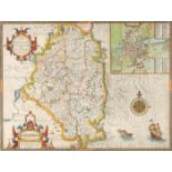
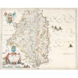
1732 Map of County Kerry by William Petty. A hand-coloured, engraved map, "The County of Kerry",
1732 Map of County Kerry by William Petty. A hand-coloured, engraved map, "The County of Kerry", as published by George Grierson, Dublin, 1731, mo...
1740 A New Map of Ireland, by Herman Moll. A hand coloured engraved map of Ireland, divided into its
1740 A New Map of Ireland, by Herman Moll. A hand coloured engraved map of Ireland, divided into its Provinces, Counties and Baronies. Inset plans...
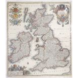
Circa 1740 Map of Britain and Ireland, by Matthias Seutter Georg Matthias Seutter - Tabula Novissima
Circa 1740 Map of Britain and Ireland, by Matthias Seutter Georg Matthias Seutter - Tabula Novissima Accuratissima. Regnorum Angliae, Scotiae, Hib...
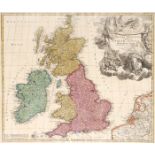
1740 Map of Britain and Ireland, by Johan Baptiste Homann. A hand-coloured, engraved map of the
1740 Map of Britain and Ireland, by Johan Baptiste Homann. A hand-coloured, engraved map of the British Isles, "Magna Britannia, Anglia Scotiae & ...
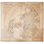
1740 L' Hemisphere Septentrional pour voir plus distinctement les Terres Arctiques. By Guillaume
1740 L' Hemisphere Septentrional pour voir plus distinctement les Terres Arctiques. By Guillaume de L'Isle; Ivan Kyrilov; Jean Cóvens; Corneille M...
1743 Map of Ireland, by Guillaume de Lisle. A hand-coloured, engraved map of Ireland, 'Irlanda',
1743 Map of Ireland, by Guillaume de Lisle. A hand-coloured, engraved map of Ireland, 'Irlanda', from 'Storio Moderna overo lo Stao Presentedi tut...
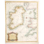
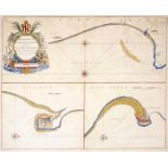
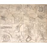
1744 A chart of St. George's Channel and the Irish Sea and plans of the Principal Ports, Towns and
1744 A chart of St. George's Channel and the Irish Sea and plans of the Principal Ports, Towns and Harbours of Ireland. A hand-coloured engraved c...
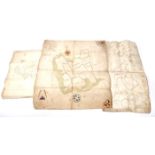
1709-1829 Estate maps of lands in Cavan, Longford, Monaghan and Wexford. Hand-coloured estate
1709-1829 Estate maps of lands in Cavan, Longford, Monaghan and Wexford. Hand-coloured estate maps, Portanure, Co. Cavan - Longford, 1709, by Dani...
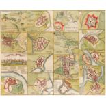
1759 Plans of the Principal Ports, Towns and Harbours of Ireland for Mr Tindall's Continuation of Mr
1759 Plans of the Principal Ports, Towns and Harbours of Ireland for Mr Tindall's Continuation of Mr Rapin's History. An uncoloured engraving of t...
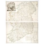
1759-1801 Maps of Ireland and Wexford and plans of the Principal Ports, Towns and Harbours of
1759-1801 Maps of Ireland and Wexford and plans of the Principal Ports, Towns and Harbours of Ireland. Ireland divided in provinces and counties, ...
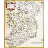
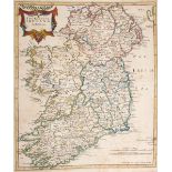
Circa 1760 Map of Ireland, by John Rocque The Kingdom of Ireland Divided into Provinces Counties and
Circa 1760 Map of Ireland, by John Rocque The Kingdom of Ireland Divided into Provinces Counties and Baronies. Showing the Archbishopricks, Bishop...
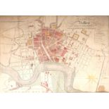
1816 Plan of Belfast A hand coloured engraving, titled, 'Plan of the town of Belfast from actual
1816 Plan of Belfast A hand coloured engraving, titled, 'Plan of the town of Belfast from actual survey by P. Mason, engraved for Smith's Belfast ...
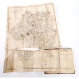
Wright, G.N. A Guide to the County Wicklow Illustrated by Engravings, after the designs of George
Wright, G.N. A Guide to the County Wicklow Illustrated by Engravings, after the designs of George Petrie, esq, and a large map of the County from ...
The New Picture of Dublin. A stranger's guide through the Irish Metropolis. William Curry, Dublin,
The New Picture of Dublin. A stranger's guide through the Irish Metropolis. William Curry, Dublin, 1828. First edition. 18mo. pp.373. 15 engraved ...
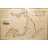
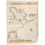
1835 Chart of Waterford Harbour A hand-coloured engraved chart of Waterford Harbour, as surveyed
1835 Chart of Waterford Harbour A hand-coloured engraved chart of Waterford Harbour, as surveyed by Samson Carter & Nobbett St. Leger, Engineers, ...
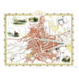
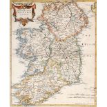
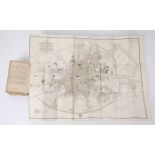
19th century Maps of Ireland and the Environs of Dublin and city plans of Dublin Cork and Belfast.
19th century Maps of Ireland and the Environs of Dublin and city plans of Dublin Cork and Belfast. Ireland, Drawn from the Best Authorities, hand-...
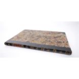
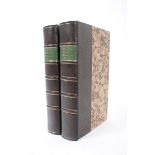
Hollinshed, Raphaell. The Histiorie of Ireland From the first inhabitation thereof unto the yeare
Hollinshed, Raphaell. The Histiorie of Ireland From the first inhabitation thereof unto the yeare 1509. Collected by Raphaell Holinshed and contin...
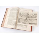
1633 Pacata Hibernia Appeased and Reduced: An Historie of the Late Warres of Ireland, especially
1633 Pacata Hibernia Appeased and Reduced: An Historie of the Late Warres of Ireland, especially within the Province of Mounster, under the Govern...
1668 Kiltartan, Co. Galway, deed. Pigott, Alexander, Taylor, Walter. Deed pertaining to the rent
1668 Kiltartan, Co. Galway, deed. Pigott, Alexander, Taylor, Walter. Deed pertaining to the rent of 56 Acres of Land at Balloy / Ballyons in the B...
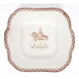
William III commemorative dish. A 19th century creamware oblong dish, the ivory ground enclosed by a
William III commemorative dish. A 19th century creamware oblong dish, the ivory ground enclosed by a foliate band and centred by a transfer printe...
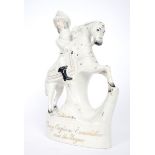
A 19th century Staffordshire figure of William III. The slip-cast figure depicting the King mounted,
A 19th century Staffordshire figure of William III. The slip-cast figure depicting the King mounted, with sword unsheathed, the base inscribed in ...
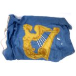
19th century, Standard of the Kingdom of Ireland, a gold harp on a blue ground. A celestial blue wool flag centred by a silver-stringed, gold Maid...
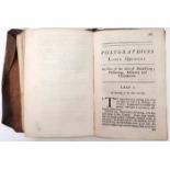
Anon. Polygraphices, 18th century herbal and almanack. Containing instructions on mixing paints,
Anon. Polygraphices, 18th century herbal and almanack. Containing instructions on mixing paints, cire perdu casting, jewellery making, metallurgy,...
Young, Arthur. A Tour in Ireland; with general observations on the present state of the kingdom:
Young, Arthur. A Tour in Ireland; with general observations on the present state of the kingdom: Made in the years 1776, 1777 and 1778. And brough...
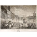
1779 The Volunteers of the City and County of Dublin. As they met on College Green on the 4th of Nov
1779 The Volunteers of the City and County of Dublin. As they met on College Green on the 4th of Nov 1779. an uncoloured engraving, after Francis ...
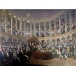
1780 and 1790 The Irish House of Commons. Two coloured prints of views of the Irish House of Commons, the earlier scene after a painting by Franci...
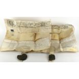
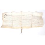
1783 Two writs concerning ownership of extensive lands in Counties Dublin and Kildare. Each three
1783 Two writs concerning ownership of extensive lands in Counties Dublin and Kildare. Each three pages in a strong clerk's hand, on vellum, heade...
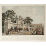
Circa 1790 Fountain on Merrion Square West, engraving. A hand coloured engraving after Barrolet of
Circa 1790 Fountain on Merrion Square West, engraving. A hand coloured engraving after Barrolet of the fountain surrounded by Dublin residents col...
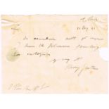
1792, May 20 Henry Grattan, signed autograph letter.
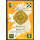
Guidon of Costello Volunteers, County Mayo. An 18th century silk swallow tailed flag of a form
Guidon of Costello Volunteers, County Mayo. An 18th century silk swallow tailed flag of a form typically carried by light cavalry regiments. The o...
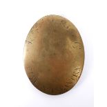
1790s Rasharkin and Finvoy Infantry, cross belt plate, brass.
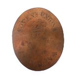
1790s Ovens Union Cavalry Cross Belt plate, copper.
1796 (31 December) eyewitness account of the failed French invasion at Bantry Three-page letter from
1796 (31 December) eyewitness account of the failed French invasion at Bantry Three-page letter from Colonel Thomas Balfour of the North Lowland F...
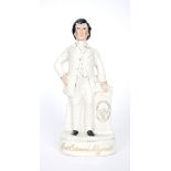
A 19th century Staffordshire figure of Lord Edward Fitzgerald. The slip-cast figure depicting the
A 19th century Staffordshire figure of Lord Edward Fitzgerald. The slip-cast figure depicting the revolutionary standing, with his hand on a pedes...
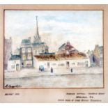
Hiding place of Lord Edward Fitzgerald, Belfast. An early 20th century naiive pastel drawing of
Hiding place of Lord Edward Fitzgerald, Belfast. An early 20th century naiive pastel drawing of thatched cottages on Frederick Street, Belfast. 6¼...
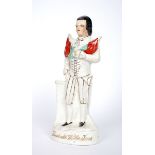
A 19th century Staffordshire figure of Theobald Wolfe Tone. The slip-cast figure depicting Wolfe
A 19th century Staffordshire figure of Theobald Wolfe Tone. The slip-cast figure depicting Wolfe Tone standing next to a pedestal, holding crossed...