Filtered by:
- Category
- List
- Grid
A subscription to the Price Guide is required to view results for auctions ten days or older. Click here for more information
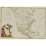

Jean Janvier, L’AMERIQUE SEPTENTRIONALE DIVISÉE EN SES PRINCIPAUX ETATS, 1762, sight 13 x 18.5 in —
Jean JanvierL’AMERIQUE SEPTENTRIONALE DIVISÉE EN SES PRINCIPAUX ETATS, 1762, hand coloured copper engraved map of Central and North America, first...
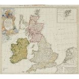
Homann Heirs after Johann Baptist Homann (1663-1724), MAGNAE BRITANNIÆ ET HIBERNIAE: A GENERAL MAP O
Homann Heirs after Johann Baptist Homann (1663-1724)MAGNAE BRITANNIÆ ET HIBERNIAE: A GENERAL MAP OF GREAT BRITAIN AND IRELAND WITH PART OF HOLLAND...
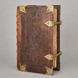
Large Dutch Brass Mounted Bible, Hendrick and Jacob Keur, Amsterdam, 1682folio, printed by Marcus Doornick, with five double page maps,Est. $200/3...
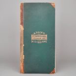
Adams ‘SynChronological Chart’ or ‘Map of History’, Centennial Edition, 1876, 27.5 x 260 in — 69.9 x
Adams ‘SynChronological Chart’ or ‘Map of History’, Centennial Edition, 1876a folding linear graphic chronological history of the world, chromolit...
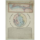
William Lane, CAPT. PARRY'S DISCOVERIES IN THE POLAR REGIONS, 1819-1820, sheet 27.4 x 19.5 in — 69.5
William LaneCAPT. PARRY'S DISCOVERIES IN THE POLAR REGIONS, 1819-1820laid paper broadsheet with circular letterpress title, two hand coloured engr...
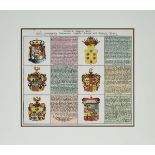
Christoph Weigel (1654-1725), ENGRAVED AND HAND COLOURED PLATE WITH GERMAN FAMILY COATS OF ARMS WITH
Christoph Weigel (1654-1725)ENGRAVED AND HAND COLOURED PLATE WITH GERMAN FAMILY COATS OF ARMS WITH TEXT, 1718from Bequemer Schul-und Reisen-Atlas ...
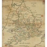
George III Needlework Map of England and Wales, 1806worked, signed and dated by Ann Eling, including part of Scotland, Ireland and the British Cha...
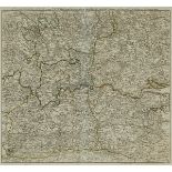
M. Bowen (fl. 17th century), A TOPOGRAPHICAL SURVEY OF THE COUNTRY, FROM THIRTY TO FORTY MILES, ROUN
M. Bowen (fl. 17th century)A TOPOGRAPHICAL SURVEY OF THE COUNTRY, FROM THIRTY TO FORTY MILES, ROUND LONDON, 1775, hand colour outlined copper engr...
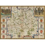
John Speede (1551-1629), SURREY DESCRIBED AND DIVIDED INTO HUNDREDS, sight 15.5 x 21.75 in — 39.4 x
John Speede (1551-1629)SURREY DESCRIBED AND DIVIDED INTO HUNDREDS, hand coloured engraved map of Surrey with large architectural insets of Richmon...
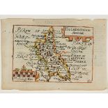
Pieter van den Keere (Dutch, 1561-c.1646), BUCKINGHAMSHIRE, C. 1627, sheet 4.1 x 6.1 in — 10.5 x 15.
Pieter van den Keere (Dutch, 1561-c.1646)BUCKINGHAMSHIRE, C. 1627hand coloured copper engraved map, framed, sheet 4.1 x 6.1 in — 10.5 x 15.5 cm; 1...
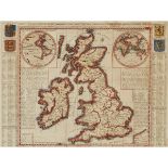
Henri Abraham Chatelain (1684-1743), NOUVELLE CARTE D'ANGLETERRE, D'ECOSSE, ET D'IRLANDE AVEC DES IN
Henri Abraham Chatelain (1684-1743)NOUVELLE CARTE D'ANGLETERRE, D'ECOSSE, ET D'IRLANDE AVEC DES INSTRUCTIONS POUR CONNOITRE LES DIFFERENTS ETATS D...
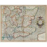
Gerard Mercator (1512-1594), WARWICUM, NORTHHAMTONIA, HUNTINGDONIA, CANTABRIGIA, SUFFOLCIA, OXONIUM,
Gerard Mercator (1512-1594)WARWICUM, NORTHHAMTONIA, HUNTINGDONIA, CANTABRIGIA, SUFFOLCIA, OXONIUM, BUCKINGHAMIA, BEFORDIA, HARFORDIA, ESSEXIA, BER...

Willem Janszoon Blaeu (1571-1638), SCOTIA REGNUM, sight 15.7 x 20.5 in — 40 x 52 cm; 26 x 30.75 in —
Willem Janszoon Blaeu (1571-1638)SCOTIA REGNUMhand coloured engraved map of Scotland, from Blaeu's Theatrum Orbis Terrarum, sight 15.7 x 20.5 in ...
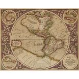
Michael Mercator (1567-1600), AMERICA SIVE INDIA NOVA AD MAGNAE GERARDI MERCATORIS AVI UNIVERSALIS I
Michael Mercator (1567-1600)AMERICA SIVE INDIA NOVA AD MAGNAE GERARDI MERCATORIS AVI UNIVERSALIS IMITATIONEM INCOMPENDIUM REDACTA, C.1620, hand co...
Guillaume de l’Isle (1675-1726), CARTE DU BRABANT, sight 24 x 25 in — 61 x 63.5 cm; 28.75 x 29.5 in
Guillaume de l’Isle (1675-1726)CARTE DU BRABANT, hand coloured engraved map of the Netherlands, sight 24" x 25" — 61 x 63.5 cm.; 28.75" x 29.5" — ...
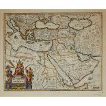
Johannes Janssonius (1588-1664), TURCICUM IMPERIUM, sight 18.5 x 22.4 in — 47 x 57 cm; 26.4 x 29.7 i
Johannes Janssonius (1588-1664)TURCICUM IMPERIUMhand coloured copper engraved map of the Turkish Empire, sight 18.5 x 22.4 in — 47 x 57 cm; 26.4 x...
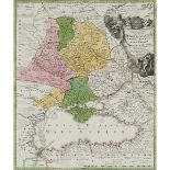
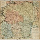
Johann Baptist Homann (1663-1724), TABULA GEOGRAPHICA QUA PARS RUSSIAE MAGNAE PONTUS EUXINUS SEU MAR
Johann Baptist Homann (1663-1724)TABULA GEOGRAPHICA QUA PARS RUSSIAE MAGNAE PONTUS EUXINUS SEU MARE NIGRUM ET TARTARIA MINOR CUM FINITIMIS BULGARI...