Refine your search
Filtered by:
- Category
- List
- Grid
A subscription to the Price Guide is required to view results for auctions ten days or older. Click here for more information
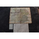

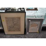
Folding Maps. North Wales interest. J. & A. Walker - To Lieut. General the Most Honorable the
Folding Maps. North Wales interest. J. & A. Walker - To Lieut. General the Most Honorable the Marquis of Anglesey, K.G.G.C.B, Lord Lieut. Custos R...
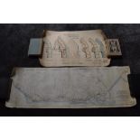
Local History. Maps and Plans, a small selection. Includes; Map of the Proposed West Cumberland,
Local History. Maps and Plans, a small selection. Includes; Map of the Proposed West Cumberland, Furness and Morecambe Bay Railway. By John Rastri...
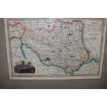
A late 19th Century Map of County Durham. Outline colour, with inset engraved view of Durham
A late 19th Century Map of County Durham. Outline colour, with inset engraved view of Durham Cathedral. Published and engraved by I. Slater. Measu...
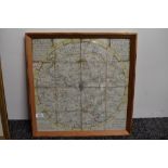
A late 18th Century Map of the City of Bath and Environs. Dated 1787. In 16 folding sections,
A late 18th Century Map of the City of Bath and Environs. Dated 1787. In 16 folding sections, linen backed, framed and glazed. Measures: approx 45...
Two Antiquarian Maps, Norfolk/Suffolk interest. One depicting the Norfolk-Suffolk border around
Two Antiquarian Maps, Norfolk/Suffolk interest. One depicting the Norfolk-Suffolk border around Thetford, circa 1816. The other taken from a chapt...
![Antiquarian Map. Valck, G. [Gerald Valck] - La Mer Mediterranee divisee en ses Principales Parties](https://portal-images.azureedge.net/auctions-2020/sr1810362/images/9a9f8799-1078-4a2e-9d5c-ac1500f9aecc.jpg?w=155&h=155)
Antiquarian Map. Valck, G. [Gerald Valck] - La Mer Mediterranee divisee en ses Principales Parties
Antiquarian Map. Valck, G. [Gerald Valck] - La Mer Mediterranee divisee en ses Principales Parties ou Mers. Amsterdam: no date, circa 1700 or afte...