Filtered by:
- Category
- List
- Grid
A subscription to the Price Guide is required to view results for auctions ten days or older. Click here for more information
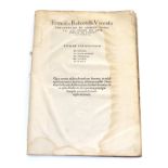

Robortello (Francesco) Francisci Robortelli Utinensis Paraphrasis in Librum Horatii ..., Basileae:
Robortello (Francesco) Francisci Robortelli Utinensis Paraphrasis in Librum Horatii ..., Basileae: Ioannem Heruagium Iuniorem, 1555, folio in sixe...
![de Hooghe (Romeyn) [1645-1708] Vertrek van S.K.H. ns Engeland den 11 Nov 1688, - Depart de S.A.R.](https://portal-images.azureedge.net/auctions-2020/srten10767/images/acd4e143-4380-47c1-b26a-ac6b008ffe3c.jpg?w=155&h=155)
de Hooghe (Romeyn) [1645-1708] Vertrek van S.K.H. ns Engeland den 11 Nov 1688, - Depart de S.A.R.
de Hooghe (Romeyn) [1645-1708] Vertrek van S.K.H. ns Engeland den 11 Nov 1688, - Depart de S.A.R. Rour Angleterre, Le 11. No 1688, J. Covens & C. ...
Roxburghe Club Rotz (Jean), The Maps and Text of the Boke of Idrography Presented by Jean Rotz to
Roxburghe Club Rotz (Jean), The Maps and Text of the Boke of Idrography Presented by Jean Rotz to Henry VIII, edited by Helen Wallis with a forewo...
Henry Teesdale & Co. New British Atlas, Containing A Complete Set of County Maps ...., Corrected
Henry Teesdale & Co. New British Atlas, Containing A Complete Set of County Maps ...., Corrected to the Year 1830, a collection of thirty hand-col...
Baugh (Robert) ....Map of Shropshire ..., Llanymynech: Robert Baugh, August 1st, 1808, large
Baugh (Robert) ....Map of Shropshire ..., Llanymynech: Robert Baugh, August 1st, 1808, large engraved map in nine sections, each section approx 46...
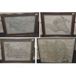
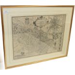
Cary (J.) A Map of the North Part of the West Riding of Yorkshire ..; A Map of the South Part of the
Cary (J.) A Map of the North Part of the West Riding of Yorkshire ..; A Map of the South Part of the West Riding of Yorkshire ...; A Map of the Ea...
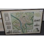
Chassereau (P.) A Plan of the City of York Survey`d by Peter Chassereau, J. Rocque, 1750, hand-
Chassereau (P.) A Plan of the City of York Survey`d by Peter Chassereau, J. Rocque, 1750, hand-coloured engraved street plan surrounded by small C...
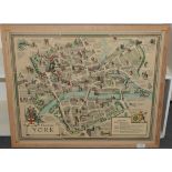
Clark (Estra) Historic York, York: Ben Johnson, 1947, colour map, sheet approx 540mm x 660mm, one
Clark (Estra) Historic York, York: Ben Johnson, 1947, colour map, sheet approx 540mm x 660mm, one horizontal and three vertical creases, tape stai...
![[Speed (John)] The Bishoprick and Citie of Durham, no date [1611 or later], hand-coloured engraved](https://portal-images.azureedge.net/auctions-2020/srten10767/images/12ce97eb-76f7-4065-ae30-ac6b00901bad.jpg?w=155&h=155)
[Speed (John)] The Bishoprick and Citie of Durham, no date [1611 or later], hand-coloured engraved
[Speed (John)] The Bishoprick and Citie of Durham, no date [1611 or later], hand-coloured engraved map, 383mm x 506mm, English text on reverse (pa...
![Speed (John) Barkshire Described, J. Sud and Georg Humble, no date [1616], hand-coloured engraved](https://portal-images.azureedge.net/auctions-2020/srten10767/images/cc3f43c2-001e-4f7c-81f9-ac6b00901c55.jpg?w=155&h=155)
Speed (John) Barkshire Described, J. Sud and Georg Humble, no date [1616], hand-coloured engraved
Speed (John) Barkshire Described, J. Sud and Georg Humble, no date [1616], hand-coloured engraved map, 380mm x 506mm, Latin text on reverse (pages...
![Speed (John) Glocestershire, John Sudbury and George Humble, 1610 [1611 or very slightly later],](https://portal-images.azureedge.net/auctions-2020/srten10767/images/b835d3ac-b917-4420-935e-ac6b00901d13.jpg?w=155&h=155)
Speed (John) Glocestershire, John Sudbury and George Humble, 1610 [1611 or very slightly later],
Speed (John) Glocestershire, John Sudbury and George Humble, 1610 [1611 or very slightly later], hand-coloured engraved map, 380mm x 510mm, Englis...
![Speed (John) The North and East Ridins of Yorkshire, John Sudbury and George Humbell, 1610 [1611],](https://portal-images.azureedge.net/auctions-2020/srten10767/images/8d36e485-0748-42ec-9ff4-ac6b00901da9.jpg?w=155&h=155)
Speed (John) The North and East Ridins of Yorkshire, John Sudbury and George Humbell, 1610 [1611],
Speed (John) The North and East Ridins of Yorkshire, John Sudbury and George Humbell, 1610 [1611], hand-coloured engraved map, 388mm x 505mm, Engl...
![[Blaeu (Johannes)] Cumbria; vulgo Cumberland, no date [c1648], hand-coloured engraved map, plate](https://portal-images.azureedge.net/auctions-2020/srten10767/images/373d4921-c066-4c56-b474-ac6b00901e8d.jpg?w=155&h=155)
[Blaeu (Johannes)] Cumbria; vulgo Cumberland, no date [c1648], hand-coloured engraved map, plate
[Blaeu (Johannes)] Cumbria; vulgo Cumberland, no date [c1648], hand-coloured engraved map, plate impression 412mm x 500mm, French text on reverse ...
![[Blaeu (Johannes)] Ducatus Eboracensis pars Borealis - The Northriding of York Shire, no date [](https://portal-images.azureedge.net/auctions-2020/srten10767/images/49b32c0f-7945-4604-9ebc-ac6b00901f36.jpg?w=155&h=155)
[Blaeu (Johannes)] Ducatus Eboracensis pars Borealis - The Northriding of York Shire, no date [
[Blaeu (Johannes)] Ducatus Eboracensis pars Borealis - The Northriding of York Shire, no date [1648], hand-coloured engraved map, plate impression...
![Seale (R.W.) Map of the County of Middlesex, no date [1756], hand-coloured engraved map, 505mm x](https://portal-images.azureedge.net/auctions-2020/srten10767/images/2a648b8a-ee88-4d1d-adb6-ac6b00901fc7.jpg?w=155&h=155)
Seale (R.W.) Map of the County of Middlesex, no date [1756], hand-coloured engraved map, 505mm x
Seale (R.W.) Map of the County of Middlesex, no date [1756], hand-coloured engraved map, 505mm x 720mm, framed and glazed (Baynton-Williams label ...
Bowen (Eman.) Britannia Depicta or Ogilby Improv'd ..., Tho. Bowles et al, 1720, engraved title page
Bowen (Eman.) Britannia Depicta or Ogilby Improv'd ..., Tho. Bowles et al, 1720, engraved title page with catalogue verso, engraved tables on four...
Speed (John) The West Ridinge of Yorkeshyre with The Most famous and fayre Citie Yorke described
Speed (John) The West Ridinge of Yorkeshyre with The Most famous and fayre Citie Yorke described 1610, John Sudbury and George Humbell, 1610 [1611...
![Speed (John) York Shire, John Sudbury and G. Humble, 1610 [1616], hand-coloured engraved map,](https://portal-images.azureedge.net/auctions-2020/srten10767/images/c8d055b4-77b3-4070-8db1-ac6b00902237.jpg?w=155&h=155)
Speed (John) York Shire, John Sudbury and G. Humble, 1610 [1616], hand-coloured engraved map,
Speed (John) York Shire, John Sudbury and G. Humble, 1610 [1616], hand-coloured engraved map, 383mm x 507mm, English text verso, (pages 77-78, reg...
![Sanson [Nicolas d'Abbeville] A collection of eleven engraved maps, no date but believed late 17th](https://portal-images.azureedge.net/auctions-2020/srten10767/images/cdea1407-3a75-48b7-ac88-ac6b00902309.jpg?w=155&h=155)
Sanson [Nicolas d'Abbeville] A collection of eleven engraved maps, no date but believed late 17th
Sanson [Nicolas d'Abbeville] A collection of eleven engraved maps, no date but believed late 17th century, comprising: Americque Septrionale; La F...
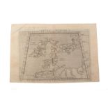
Ruscelli (Girolamo) after Claudius Ptolemy Tabula Europae I, an early map of the British Isles, no
Ruscelli (Girolamo) after Claudius Ptolemy Tabula Europae I, an early map of the British Isles, no date [16th century or later], sheet 217mm x 317...
Russell (J.) Chart of the British Channel with the Opposite Coast of the United Kingdom and the
Russell (J.) Chart of the British Channel with the Opposite Coast of the United Kingdom and the Republic of France, J. Stratford, Nov. 5th, 1803, ...
![Battle of Vigo Bay (1702) An Exact Draught of the Bay and Harbour of Vigo, no date [c1740], hand-](https://portal-images.azureedge.net/auctions-2020/srten10767/images/459afa2b-22e8-4327-b045-ac6b009024ba.jpg?w=155&h=155)
Battle of Vigo Bay (1702) An Exact Draught of the Bay and Harbour of Vigo, no date [c1740], hand-
Battle of Vigo Bay (1702) An Exact Draught of the Bay and Harbour of Vigo, no date [c1740], hand-coloured map, sheet 385mm x 515mm; Battle of the ...
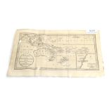
Australia Chart of New Holland, with the Adjacent Countries and New Discover'd Islands, The Univeral
Australia Chart of New Holland, with the Adjacent Countries and New Discover'd Islands, The Univeral Magazine, 1787, engraved map with inset plan ...
![Pont (Timotheo) Lidalia vel Lidisdail, [J. Blaeu], no date [1654 or later], hand-coloured engraved](https://portal-images.azureedge.net/auctions-2020/srten10767/images/c0a7db64-c233-4fc6-8d1e-ac6b009025f7.jpg?w=155&h=155)
Pont (Timotheo) Lidalia vel Lidisdail, [J. Blaeu], no date [1654 or later], hand-coloured engraved
Pont (Timotheo) Lidalia vel Lidisdail, [J. Blaeu], no date [1654 or later], hand-coloured engraved map, plate impression 415mm x 520mm, German tex...
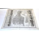
Seiffert (Guglielmo) Pianta di Venzia, 1859, map of the city with views above and below, printed
Seiffert (Guglielmo) Pianta di Venzia, 1859, map of the city with views above and below, printed on linen, sheet 737mm x 635mm, folded ...[more]
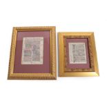
Illuminated Manuscript Vellum Leaf with latin manuscript, recto has six initials, four line
Illuminated Manuscript Vellum Leaf with latin manuscript, recto has six initials, four line fillers and a decorative foliate design to margin, fou...