Filtered by:
- Category
- List
- Grid
A subscription to the Price Guide is required to view results for auctions ten days or older. Click here for more information
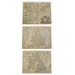

John Speed 'The Kingdome of Great Britaine & Ireland', William Humble, 1653, uncoloured map,
John Speed 'The Kingdome of Great Britaine & Ireland', William Humble, 1653, uncoloured map, engraved by J. Hondius, plate mark 387mm x 515mm, Eng...
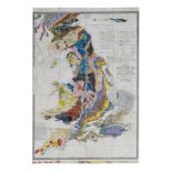
Walker (J. & C.) A Geological Map of England, Wales and Part of Scotland, Showing also the Inland
Walker (J. & C.) A Geological Map of England, Wales and Part of Scotland, Showing also the Inland Navigation by Means of Rivers & Canals With thei...
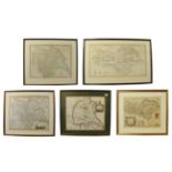
Bowen (Eman.) An Accurate Map of the County of York, Divided into its Ridings and subdivided into
Bowen (Eman.) An Accurate Map of the County of York, Divided into its Ridings and subdivided into Wapentakes .., nd., hand-coloured map, approx 44...
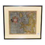
Mercatorem (Gerardum) West Morlandia, Lancastria, Cestria, Caernarvan, Denbigh, Flint, Merionidh,
Mercatorem (Gerardum) West Morlandia, Lancastria, Cestria, Caernarvan, Denbigh, Flint, Merionidh, Montgomery, Salopia, cum insufis Mania et Angles...
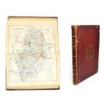
Walker (J. and C.) Hobson's Fox-Hunting Atlas; containing Seperate Maps of Every County in England, and the Three Ridings of Yorkshire; Comprising...