Filtered by:
- Category
- List
- Grid
A subscription to the Price Guide is required to view results for auctions ten days or older. Click here for more information
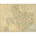

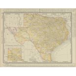
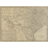
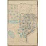
AN ANTIQUE MAP, "Map of Texas," DES MOINES, IOWA, CIRCA 1912, color engraving on paper, a fragment
AN ANTIQUE MAP, "Map of Texas," DES MOINES, IOWA, CIRCA 1912, color engraving on paper, a fragment from a larger atlas, pages 36-37, published by ...
AN ANTIQUE MAP, "Rand McNally Standard Map of Oklahoma," CHICAGO, EARLY 20TH CENTURY, color engraving on paper, with view of "Western Portion of O...
AN ANTIQUE AUTOMOBILE MAP, "Clason's Guide Map of Oklahoma," DENVER, COLORADO, 1917, color engraving
AN ANTIQUE AUTOMOBILE MAP, "Clason's Guide Map of Oklahoma," DENVER, COLORADO, 1917, color engraving on paper, published by The Clason Map CO., wi...
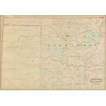
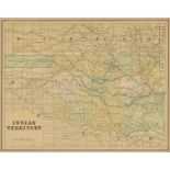
AN ANTIQUE AMERICAN RECONSTRUCTION ERA MAP, "Indian Territory and Texas, Northwest Portion," 1874,
AN ANTIQUE AMERICAN RECONSTRUCTION ERA MAP, "Indian Territory and Texas, Northwest Portion," 1874, hand colored engraving on paper, a page fragmen...
AN ANTIQUE MAP, "Rand McNally & Co.'s Texas," CHICAGO, CIRCA 1892, color engraving on paper, a
AN ANTIQUE MAP, "Rand McNally & Co.'s Texas," CHICAGO, CIRCA 1892, color engraving on paper, a page fragment from Rand McNally's New Business Atla...
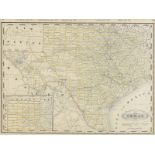
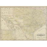
AN ANTIQUE MAP, "Railroad and County Map of Texas," CHICAGO, ILLINOIS, 1900-1909, color engraving on
AN ANTIQUE MAP, "Railroad and County Map of Texas," CHICAGO, ILLINOIS, 1900-1909, color engraving on paper, published by George F. Cram. 7" x 10" ...
AN ANTIQUE MAP, "Rand McNally & Co.'s New 11" x 14" Map of Indian Territory and Oklahoma," CHICAGO, CIRCA 1895, color engraving on paper, showing ...
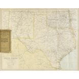
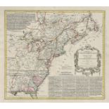
AN ANTIQUE RECONSTRUCTION ERA MAP, "County Map of the State of Texas, Also showing portions of
AN ANTIQUE RECONSTRUCTION ERA MAP, "County Map of the State of Texas, Also showing portions of adjoining States and Territories," PHILADELPHIA, 18...

AN ANTIQUE MAP, "United States of North America, Southwest Sheet," 1893-1912, color engraving on
AN ANTIQUE MAP, "United States of North America, Southwest Sheet," 1893-1912, color engraving on paper, engraved, printed and published by W. & A....
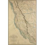
AN ANTIQUE MAP, "Carte de la Côte de l'Amérique, sur l'océan pacifiqque septentrional compernant Le Territorie de l'Orégon, les Californies, L...
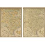
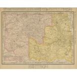
TWO VINTAGE MAPS, "Vertical Map of Texas," CHICAGO, EARLY 20TH CENTURY, color engravings on paper,
TWO VINTAGE MAPS, "Vertical Map of Texas," CHICAGO, EARLY 20TH CENTURY, color engravings on paper, published by Rand McNally, showing railroad lin...
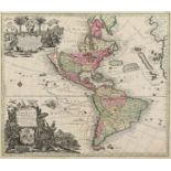
AN ANTIQUE MAP, "Novus Orbis sive America Meridionalis et Septentrionalis," AUGSBURG, CIRCA 1740,
AN ANTIQUE MAP, "Novus Orbis sive America Meridionalis et Septentrionalis," AUGSBURG, CIRCA 1740, hand colored engraving on paper, published by Ma...
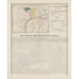
AN ANTIQUE MAP, "Map of the Colonization Grants to Zavala, Vehlein, & Burnet in Texas, Belonging
AN ANTIQUE MAP, "Map of the Colonization Grants to Zavala, Vehlein, & Burnet in Texas, Belonging to Galveston Bay & Texas Land Co.," NEW YORK, JAN...
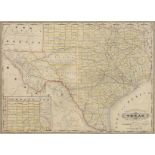
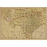
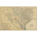
AN ANTIQUE MAP, "Railroad and County Map of Texas," CHICAGO, ILLINOIS, 1887, color engraving on
AN ANTIQUE MAP, "Railroad and County Map of Texas," CHICAGO, ILLINOIS, 1887, color engraving on paper, published by George F. Cram (1842-1928), wi...
AN ANTIQUE POCKET MAP, "Railroad and County Map of Texas," CHICAGO, LATE 19TH CENTURY, color ink
AN ANTIQUE POCKET MAP, "Railroad and County Map of Texas," CHICAGO, LATE 19TH CENTURY, color ink engraving, a page fragment from an atlas, plates ...
AN ANTIQUE MAP, "Carte particulière de Isthmus, ou Darien, qui ..." AMSTERDAM, 18TH/19TH CENTURY
AN ANTIQUE MAP, "Carte particulière de Isthmus, ou Darien, qui comprend le Golfe de Panama & c., Cartegene et les isles aux environs," AMSTERDAM, ...
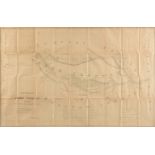
AN ANTIQUE SURVEY MAP, "Boundary of the Creek Country Surveyed under the Direction of the Bureau
AN ANTIQUE SURVEY MAP, "Boundary of the Creek Country Surveyed under the Direction of the Bureau of Topographical Engineers," 1857-1858, engraving...
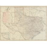
AN ANTIQUE MAP, "Rand McNally & Co.'s New 11" x 14" Map of Texas," CHICAGO, CIRCA 1895, color
AN ANTIQUE MAP, "Rand McNally & Co.'s New 11" x 14" Map of Texas," CHICAGO, CIRCA 1895, color engraving on paper, with view of "The Panhandle of T...
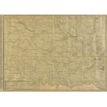
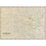
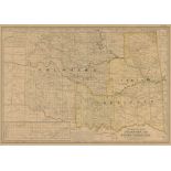
AN ANTIQUE MAP, "Rand McNally & Co.'s New Business Atlas Map of Indian Territory and Oklahoma,"
AN ANTIQUE MAP, "Rand McNally & Co.'s New Business Atlas Map of Indian Territory and Oklahoma," CIRCA 1903, color engraving on paper, showing chie...
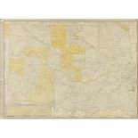
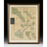
AN ANTIQUE MAP, "Texas Western Portion," 1874, hand colored engraving on paper, published by Asher &
AN ANTIQUE MAP, "Texas Western Portion," 1874, hand colored engraving on paper, published by Asher & Adams. 22 3/4" x 16 1/2" Provenance: Property...
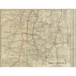
AN ANTIQUE MAP OF OKLAHOMA, "Indian Territory," CHICAGO, CIRCA 1901, color engraving on paper,
AN ANTIQUE MAP OF OKLAHOMA, "Indian Territory," CHICAGO, CIRCA 1901, color engraving on paper, published by George F. Cram (1842-1948), a page fra...
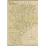
A VINTAGE MAP, "Texas," CIRCA 1890, engraving on paper, a page fragment from an atlas, plate 68,
A VINTAGE MAP, "Texas," CIRCA 1890, engraving on paper, a page fragment from an atlas, plate 68, with view of the Panhandle, lacking Jeff Davis Co...
AN ANTIQUE MAP, "Eastern Half of Texas," CIRCA 1901, color engraving on paper, plate 350-351,
AN ANTIQUE MAP, "Eastern Half of Texas," CIRCA 1901, color engraving on paper, plate 350-351, published by George F. Cram (1842-1928), a page frag...
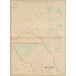
AN ANTIQUE MAP, "Railroad and County Map of Indian Territory," New York, 1885-1893, hand colored
AN ANTIQUE MAP, "Railroad and County Map of Indian Territory," New York, 1885-1893, hand colored engraving on paper, published by A.A. Grant, plat...
AN ANTIQUE MAP, "United States (South Central)," LIVERPOOL, GREAT BRITAIN, 1891-1917, a color
AN ANTIQUE MAP, "United States (South Central)," LIVERPOOL, GREAT BRITAIN, 1891-1917, a color engraving on paper,"Philips' Authentic Imperial Maps...
A CIVIL WAR ERA ANTIQUE MAP, "Johnson's New Map of the State Of Texas," NEW YORK, 1860-1863, hand
A CIVIL WAR ERA ANTIQUE MAP, "Johnson's New Map of the State Of Texas," NEW YORK, 1860-1863, hand colored engraving on paper, page fragments from ...
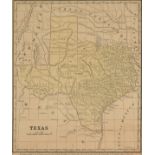
AN ANTIQUE ANTEBELLUM MAP, "Texas," NEW YORK, 1853-1856, engraving on paper, engraved by S.F. Baker,
AN ANTIQUE ANTEBELLUM MAP, "Texas," NEW YORK, 1853-1856, engraving on paper, engraved by S.F. Baker, published by Daniel Burgess & Co. 10 1/2" x 8...
AN ANTIQUE MAP, "The Century Atlas, Oklahoma and Indian Territory," 1897-1933, color print on paper,
AN ANTIQUE MAP, "The Century Atlas, Oklahoma and Indian Territory," 1897-1933, color print on paper, "Copyright 1897, by The Century Co., New York...
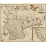
AN ANTIQUE MAP, "Accurata Scaniæ, Belkingiæ et Hallandiæ," AMSTERDAM, CIRCA 1680, hand colored
AN ANTIQUE MAP, "Accurata Scaniæ, Belkingiæ et Hallandiæ," AMSTERDAM, CIRCA 1680, hand colored engraving on paper, published by Frederick de Wi...
AN ANTIQUE MAP, "Texas and Indian Territory," 1880-1901, hand colored engraving on paper, a page
AN ANTIQUE MAP, "Texas and Indian Territory," 1880-1901, hand colored engraving on paper, a page fragment from an atlas, pages 66-67, unusually a ...
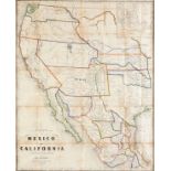
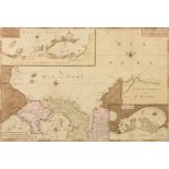
AN ANTIQUE POCKET MAP, "Map of Mexico and California, Second Edition," SAINT LOUIS, MISSOURI,
AN ANTIQUE POCKET MAP, "Map of Mexico and California, Second Edition," SAINT LOUIS, MISSOURI, 1863, hand colored engraving on paper, compiled by J...
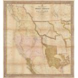
AN ANTIQUE REPUBLIC OF TEXAS MAP, "A New Map of Texas, Oregon, and California," PHILADELPHIA,
AN ANTIQUE REPUBLIC OF TEXAS MAP, "A New Map of Texas, Oregon, and California," PHILADELPHIA, 1846, hand colored engraving on paper, "...With the ...
AN IMPORTANT REPUBLIC OF TEXAS MAP, "Map of Texas," NEW YORK, 1839, hand colored engraving on paper,
AN IMPORTANT REPUBLIC OF TEXAS MAP, "Map of Texas," NEW YORK, 1839, hand colored engraving on paper, "Compiled from surveys on record in the Gener...
AN ANTIQUE MAP, "America Septentrionalis," NUREMBERG, 1756, hand color engraving on paper, Homann
AN ANTIQUE MAP, "America Septentrionalis," NUREMBERG, 1756, hand color engraving on paper, Homann Heirs under direction of Johann Christoph (1703-...
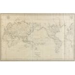
AN ANTIQUE MAP, "Mappe Monde ou Carte Réduite Des Parties Connues du Globe, Pour fervir au Voyage
AN ANTIQUE MAP, "Mappe Monde ou Carte Réduite Des Parties Connues du Globe, Pour fervir au Voyage de la Pérouse," PARIS, 1797, engraving on pape...
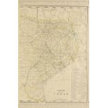
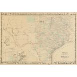
AN ANTIQUE MAP, "Eastern Half of Texas," CIRCA 1900, color engraving on paper. 21" x 14" Provenance:
AN ANTIQUE MAP, "Eastern Half of Texas," CIRCA 1900, color engraving on paper. 21" x 14" Provenance: Property from a Fortune 500 Energy Company, H...
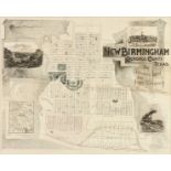
A PROMOTIONAL MAP AND LAYOUT FOR THE CREATION OF A PROPOSED TEXAS CITY "NEW BIRMINGHAM, CHEROKEE
A PROMOTIONAL MAP AND LAYOUT FOR THE CREATION OF A PROPOSED TEXAS CITY "NEW BIRMINGHAM, CHEROKEE COUNTY," NEW YORK, CIRCA 1888, this printed plan ...
AN ANTIQUE MAP, "Railroad and County Map of Texas," NEW YORK, CIRCA 1886, color engraving on
AN ANTIQUE MAP, "Railroad and County Map of Texas," NEW YORK, CIRCA 1886, color engraving on paper, a page fragment from Grant’s Rail Road & Bus...
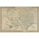
AN ANTIQUE MAP, "Map of Texas," 1890-1898, color engraving on paper, a page fragment from an
AN ANTIQUE MAP, "Map of Texas," 1890-1898, color engraving on paper, a page fragment from an atlas, with a view of The Northern or Panhandle Count...