Filtered by:
- Category
- List
- Grid
A subscription to the Price Guide is required to view results for auctions ten days or older. Click here for more information
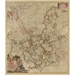

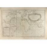
AN ANTIQUE MAP, "Circulus Electorum Rheni Sive Rhenanus Inferior," AMSTERDAM, 17TH/18TH CENTURY,
AN ANTIQUE MAP, "Circulus Electorum Rheni Sive Rhenanus Inferior," AMSTERDAM, 17TH/18TH CENTURY, hand colored engraving on paper, "... Comptectens...
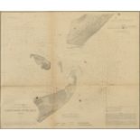
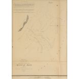
AN ANTIQUE AMERICAN CIVIL WAR/RECONSTRUCTION ERA U.S. COAST SURVEY MAP, "Galveston Entrance, Texas,"
AN ANTIQUE AMERICAN CIVIL WAR/RECONSTRUCTION ERA U.S. COAST SURVEY MAP, "Galveston Entrance, Texas," 1867, ink engraving on paper, plate no. 13, B...
AN ANTIQUE FINLAND MAP, "Finmarchiæ et Laplandiæ," 17TH/18TH CENTURY, hand colored ink engraving
AN ANTIQUE FINLAND MAP, "Finmarchiæ et Laplandiæ," 17TH/18TH CENTURY, hand colored ink engraving on paper, after Frederik de Wit (Dutch 1630-1706)...
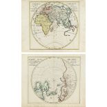
TWO ANTIQUE MAPS, "Orbis Terrarum veteribus cogniti Typus admentem veterum Geographorum præsentatur a Christ," AND "Facies Poli Arctici," NUREMBUR...
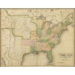
AN ANTIQUE MAP, "United States of America," NEW YORK, 1827, hand colored engraving on paper, engraved by Benjamin Tanner (1775-1848). 17" X 21 5/8...
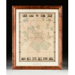
AN ANTIQUE RECONSTRUCTION ERA MAP, "Kosse & Scott's Map of the City of Houston and Environs,"
AN ANTIQUE RECONSTRUCTION ERA MAP, "Kosse & Scott's Map of the City of Houston and Environs," 1867, hand colored engraving on paper, compiled and ...
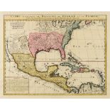
AN ANTIQUE MAP, "Carte Contetant Le Royaume du Mexique et la Floride,"1719-17, HENRI ABRAHAM
AN ANTIQUE MAP, "Carte Contetant Le Royaume du Mexique et la Floride,"1719-17, HENRI ABRAHAM CHÂTELAIN (1684-1743), AMSTERDAM, from the Atlas Hist...
AN ANTIQUE MAP, "The Century Atlas, Texas, Western Part and Panhandle," color engraving on paper, "
AN ANTIQUE MAP, "The Century Atlas, Texas, Western Part and Panhandle," color engraving on paper, "Copyright 1897, by The Century Co., New York," ...
AN ANTIQUE MAP, "U.S. Cost Survey, Reconnaissance of Aransas Pass, Texas," CIRCA 1853, ink engraving
AN ANTIQUE MAP, "U.S. Cost Survey, Reconnaissance of Aransas Pass, Texas," CIRCA 1853, ink engraving on paper, sketch I No. 5, originally drafted ...
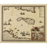
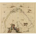
AN ANTIQUE MALTA MAP, "Insula Malta Accuratisime Delinæta, Urbibus et Fortalitiis Exprella, Federico
AN ANTIQUE MALTA MAP, "Insula Malta Accuratisime Delinæta, Urbibus et Fortalitiis Exprella, Federico de Wit, Amsterdam," 17TH CENTURY, hand colore...
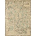
A VINTAGE MAP, "Geologic Map of Oklahoma," 1926, color engraving on paper, "Compiled by Hugh D.
A VINTAGE MAP, "Geologic Map of Oklahoma," 1926, color engraving on paper, "Compiled by Hugh D. Miser, of The United States Geological Survey. Pre...
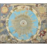
AN ANTIQUE MAP, "Systema Solare et Planetarium," NUREMBERG, 18TH CENTURY, parcel gilt and hand
AN ANTIQUE MAP, "Systema Solare et Planetarium," NUREMBERG, 18TH CENTURY, parcel gilt and hand colored engraving, after work by cartographer Johan...
AN ANTIQUE MAP, "Carte des Variations de la Boussole," PARIS, CIRCA 1765, engraving on paper,
AN ANTIQUE MAP, "Carte des Variations de la Boussole," PARIS, CIRCA 1765, engraving on paper, hydrographer Jacques Nicolas Bellin (1703-1772), pla...
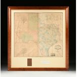
A RARE ANTIQUE CIVIL WAR ERA MAP, "Pressler's Map of the State of Texas," THE STRAND, GALVESTON,
A RARE ANTIQUE CIVIL WAR ERA MAP, "Pressler's Map of the State of Texas," THE STRAND, GALVESTON, 1862, hand colored engraving on paper, "Compiled ...
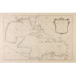
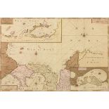
AN ANTIQUE MAP, "Carte Reduite du Golphe du Mexique et Des Isles de L'Amerique," PARIS, 1749, hand
AN ANTIQUE MAP, "Carte Reduite du Golphe du Mexique et Des Isles de L'Amerique," PARIS, 1749, hand colored engraving on paper, by Jacques-Nicolas ...
AN ANTIQUE MAP, "America Septentrionalis," AUGSBURG, 1790, hand colored engraving on paper, after
AN ANTIQUE MAP, "America Septentrionalis," AUGSBURG, 1790, hand colored engraving on paper, after Tobias Conrad Lotter (1717-1777), showing the No...
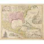
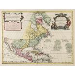
AN ANTIQUE MAP, "Regni Mexicani Seu Novæ Hispaniæ, Ludovicianæ, N. Angliæ, Carolina, Virgina et
AN ANTIQUE MAP, "Regni Mexicani Seu Novæ Hispaniæ, Ludovicianæ, N. Angliæ, Carolina, Virgina et Pennsylvaniæ necnon Insvlarvm Archipelagi Mexicani...
AN ANTIQUE AMERICAN RECONSTRUCTION ERA MAP, "Johnson's Arkansas, Mississippi and Louisiana," 1865-
AN ANTIQUE AMERICAN RECONSTRUCTION ERA MAP, "Johnson's Arkansas, Mississippi and Louisiana," 1865-1869, hand colored ink engraving on paper, print...
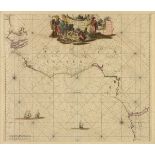
AN ANTIQUE IVORY COAST MAP, "Tractus Littorales Guineæ a Promontorio Verde usque ad Sinum Catenbelæ Apud F. de Wit," 1739-1745, hand colored engra...
AN ANTIQUE MAP, "Carte particulière de Isthmus, ou Darien, qui comprend le Golfe de Panama & c.,
AN ANTIQUE MAP, "Carte particulière de Isthmus, ou Darien, qui comprend le Golfe de Panama & c., Cartegene et les isles aux environs," AMSTERDAM, ...
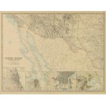
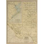
AN ANTIQUE MAP, "United States of North America, Southwest Sheet," 1893-1912, color engraving on
AN ANTIQUE MAP, "United States of North America, Southwest Sheet," 1893-1912, color engraving on paper, engraved, printed and published by W. & A....
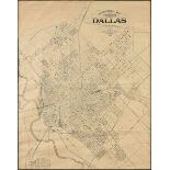
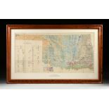
AN ANTIQUE MAP, "Topographical Map for Commerce of Dallas, Texas," 1890, engraving on paper,
AN ANTIQUE MAP, "Topographical Map for Commerce of Dallas, Texas," 1890, engraving on paper, published by William A. Flamm & Co., Baltimore, Maryl...