Filtered by:
- Category
- List
- Grid
This auctioneer has chosen to not publish their results. Please contact them directly for any enquiries.
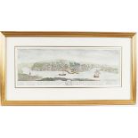

MAP OF KINSALE
Panorama of Kinsale taken from Charles Smiths "The ancient and present state of Cork City" published by Wilson Dublin 1774, Framed, Smith was one ...
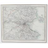
MAP OF THE ENVIRONS OF DUBLIN
Published by the Society for the Diffusion of Useful knowledge. The Society's main purpose was to encourage universal literacy by publishing numbe...
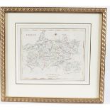
COUNTY MAP OF LIMERICK
taken from Samuel Lewis "Topographical Dictionary of Ireland" 1837. The dictionary was the first detailed study of its kind and as it was publishe...
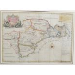
COUNTY MAP OF WATERFORD
From Smiths History of Waterford, Published Dublin. Framed and coloured Circa 1756
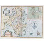
JOHN SPEED MAP
of Munster 1676. Bassett and Chiswell edition. framed and coloured
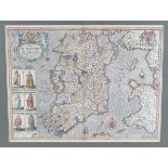
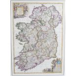
JOHN SPEED MAP
of the Kingdom of Ireland. from The Theatre of the Empire of Great Britaine, book 4 Sudbury and Humble edition framed and double glazed
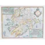
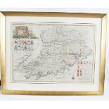
JOHN SPEED MAP
of the Province of Leinster 1676., Bassett and Chiswell edition. framed and coloured
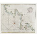
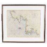
CHART LOUGH SWILLY/SLYNE HEAD
by Mount and Page circa 1760. framed
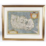
ORTELIUS MAP
Hibernia (Ireland) 1598 edition. The earliest map of Ireland which appeared in an Atlas. From "Theatrum Orbis Terrarum". Framed and double glazed
IRISH CHARTS
a set of six framed eighteenth-century charts of Irish waters. Mount and Page circa 1750. Framed
DE WIT IRELAND
Map of Ireland Regnum Hibernniae. Abl. DS2. framed, original colour
CORK MAP
Map of the County of Cork from Charles Smith. History of Cork circa 1760. Framed and coloured
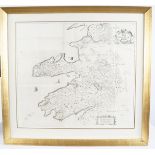
KERRY MAP
William Pettys map of the County of Kerry from "Hiberniae Delineatio" circa 1685. Framed
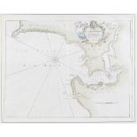
KINSALE MAP
Chart of Kinsale by Captain Greville Collins from the British Coasting pilot circa 1730. Framed