Filtered by:
- Lots with images only,
- Category
- List
- Grid
A subscription to the Price Guide is required to view results for auctions ten days or older. Click here for more information
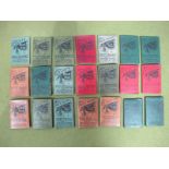

Twenty-one Late XIX Century Cyclists Fold-out Maps, sponsored by Pattison's Scotch Whisky, each with
Twenty-one Late XIX Century Cyclists Fold-out Maps, sponsored by Pattison's Scotch Whisky, each with a different district of the UK.
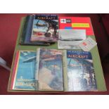
4 x The Wonder Book of Aircraft, circa 1930's - 1950's, The Wonders of World Aviation Volume One
4 x The Wonder Book of Aircraft, circa 1930's - 1950's, The Wonders of World Aviation Volume One edited by Clarence Winchester circa late 1930's, ...
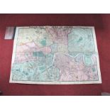
A James Wyld 'Geographer to Her Majesty' Wyld's New Plan of London and its Vicinity 1872, the map
A James Wyld 'Geographer to Her Majesty' Wyld's New Plan of London and its Vicinity 1872, the map details the railways and its well worthy of clos...
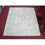
Official Railway Map of England and Wales, prepared and published at the Railway Clearing House,
Official Railway Map of England and Wales, prepared and published at the Railway Clearing House, London, 1926.
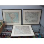
Stielers Hand Atlas, a map of America, 35 x 43cms, framed and glazed and two other similar maps. (
Stielers Hand Atlas, a map of America, 35 x 43cms, framed and glazed and two other similar maps. (3)
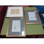
Two Early Double Framed Road Maps, London to Horsham, Arundel to Chichester, London to Rye, a
Two Early Double Framed Road Maps, London to Horsham, Arundel to Chichester, London to Rye, a later map London to Weymouth. (3)