Filtered by:
- Category
4 items
- List
- Grid
This auctioneer has chosen to not publish their results. Please contact them directly for any enquiries.
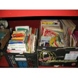

Lot 27
A Quantity of Bartholomews and O.S. Maps, varying locations, including Continental maps, circa
A Quantity of Bartholomews and O.S. Maps, varying locations, including Continental maps, circa 1960's "Car Mechanics" and "Practical Motorists" pe...
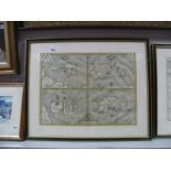
Lot 564
John Speede. XVII Century British Islands Map, hand coloured featuring "Holly Iland", "Garnsey", "
John Speede. XVII Century British Islands Map, hand coloured featuring "Holly Iland", "Garnsey", "Farne" and "Jersey". To be sold by Thomas Basset...
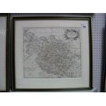
Lot 565
Robert Morden, Early XVII Century Map of West Riding of Yorkshire, uncoloured. Approximately
Robert Morden, Early XVII Century Map of West Riding of Yorkshire, uncoloured. Approximately 35x40cms.
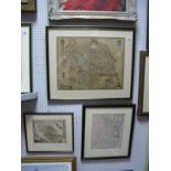
Lot 566
Hand Coloured Thomas Moule Type Map of Yorkshire, featuring anglers surmounting cartouche "Ducatus
Hand Coloured Thomas Moule Type Map of Yorkshire, featuring anglers surmounting cartouche "Ducatus Eboracensis Anglice Yorkshire", bottom right, 3...