Filtered by:
- Category
- List
- Grid
A subscription to the Price Guide is required to view results for auctions ten days or older. Click here for more information
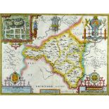

JOHN SPEED antiquarian coloured map - 'The Countie of Radnor described and the shyretownes sittuatione', John Sudbury & George Humble, 1618, inset...
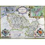
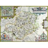
JOHN SPEED antiquarian coloured map - Denbighshire, John Sudbury & George Humble, 1610, inset town
JOHN SPEED antiquarian coloured map - Denbighshire, John Sudbury & George Humble, 1610, inset town plan of Denbigh, framed and glazed verso, 37 x...
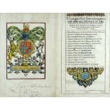
JOHN SPEED engraved atlas title-page - entitled 'The Second Booke Containing The Principality of
JOHN SPEED engraved atlas title-page - entitled 'The Second Booke Containing The Principality of Wales...', John Legatt for William Humble edition...
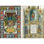
JOHN SPEED rare coloured engraved atlas title-pages - entitled 'The Theatre of the Empire of Great
JOHN SPEED rare coloured engraved atlas title-pages - entitled 'The Theatre of the Empire of Great Britaine...', George Humble edition, 1627' and,...
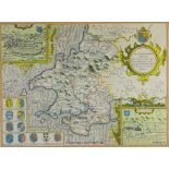
JOHN SPEED coloured antiquarian map - 'Montgomeryshire, Described by Christopher Saxton, Augmented
JOHN SPEED coloured antiquarian map - 'Montgomeryshire, Described by Christopher Saxton, Augmented and Published by John Speed and are to be sold...
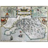
JOHN SPEED coloured antiquarian map - 'Penbrokeshyre' (Pembrokeshire) with inset plan of St David's,
JOHN SPEED coloured antiquarian map - 'Penbrokeshyre' (Pembrokeshire) with inset plan of St David's, John Sudbury and George Humbell, edition 1610...
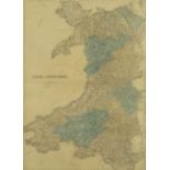
JOHN BARTHOLOMEW coloured touring road and rail map - 'North & South Wales', circa, 1890, 58 x
JOHN BARTHOLOMEW coloured touring road and rail map - 'North & South Wales', circa, 1890, 58 x 42cms ...[more]
JOHN SPEED double engraving map of 'Glamorganshyre', with plans of 'Cardyfe' and 'Landaffe', hand-
JOHN SPEED double engraving map of 'Glamorganshyre', with plans of 'Cardyfe' and 'Landaffe', hand-coloured, Sudbury & Humble edition, 1610, 38 x 5...