
Refine your search
Filtered by:
- Category
3 items
- List
- Grid
A subscription to the Price Guide is required to view results for auctions ten days or older. Click here for more information
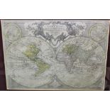

Tobias Conrad Lotter: 18th century engraved map of the world, circa 1775, titled Mappa Totius Mundi, with hand colouring, plate 45 x 63.5cm, glaze...
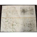
18th century folding map of Colchester and environs, by John Chapman and Peter Andre, comprising the northern portion of their 1777 map of Essex, ...
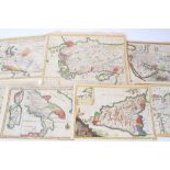
Small group of 17th and 18th century hand coloured maps, including 1779 map of Africa Propria and Numidia by Basire, 20 x 27cm, 1745 Basire map of...