Filtered by:
- Category
- List
- Grid
A subscription to the Price Guide is required to view results for auctions ten days or older. Click here for more information

Chart engraving of Falmouth by Captain Greenvile Collins 33cm x 42cm marked to Sir Peter Killegrew, framed and glazed.
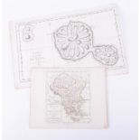
A map of Tahiti from an Edition of Cook's Voyages, dated 1769, probably published circa 1774,
A map of Tahiti from an Edition of Cook's Voyages, dated 1769, probably published circa 1774, overall size 17cm x 43cm, together with a map of Gre...
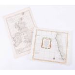
A map of South Africa by Nicholas Belun, circa 1770, overall size 27cm x 31cm, together with a map
A map of South Africa by Nicholas Belun, circa 1770, overall size 27cm x 31cm, together with a map of the British Isles, Bonne, 1780, overall size...
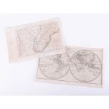
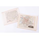
Map of Paraguay, a copy by A. Van. Krevelt, 16cm x 38cm, 1773, together with Map of the World,
Map of Paraguay, a copy by A. Van. Krevelt, 16cm x 38cm, 1773, together with Map of the World, Bonne, 1780, 25cm x 42cm
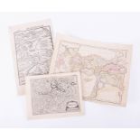
A map of Caucasus, showing Colchis (where Jason found the golden fleece) a woodcut engraving by
A map of Caucasus, showing Colchis (where Jason found the golden fleece) a woodcut engraving by Munster, circa 1560, overall size 32cm x 19cm, tog...
A map of Canterbury by Cole and Roper, later colouring, circa 1806, 22cm x 28cm, together with a map
A map of Canterbury by Cole and Roper, later colouring, circa 1806, 22cm x 28cm, together with a map of Austria by Robert de Vaugondy, circa 1748,...