
Filtered by:
- Category
- List
- Grid
A subscription to the Price Guide is required to view results for auctions ten days or older. Click here for more information


Laval, Antoine Jean, Voyage de la Louisiane, fait par ordre du roy en l'annee mil Sept cent vingt:
Laval, Antoine Jean, Voyage de la Louisiane, fait par ordre du roy en l'annee mil Sept cent vingt: Dans lequel sont traitees diverses matieres de ...
![[Mitchell's Universal Atlas], A New Universal Atlas Containing Maps of the Various Empires,](https://portal-images.azureedge.net/auctions-2017/srne10025/images/7c13a869-dd08-4af1-d1d3-e0031ae203dd.jpg?w=155&h=155)
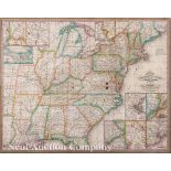
[Mitchell's Universal Atlas], A New Universal Atlas Containing Maps of the Various Empires, Kingdoms, States and Republics of the World. With a Sp...
![[New Orleans Exposition Map], "The World's Industrial and Cotton Centennial Exposition, New Orleans,](https://portal-images.azureedge.net/auctions-2017/srne10025/images/69b612e1-e73f-4bb3-fe0d-8d4f52784835.jpg?w=155&h=155)
[New Orleans Exposition Map], "The World's Industrial and Cotton Centennial Exposition, New Orleans,
[New Orleans Exposition Map], "The World's Industrial and Cotton Centennial Exposition, New Orleans, LA...Plan No. 2 Map of the City of New Orlean...
Probst, Johann Michael, "Nova Mappa Geographica Americae Septentrionalis", Augsberg, 1782, hand-
Probst, Johann Michael, "Nova Mappa Geographica Americae Septentrionalis", Augsberg, 1782, hand-colored, based on the Le Rouge edition of Henry Po...
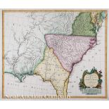
D'Anville, Jean Baptiste Bourguignon, "Carte de la Louisiane", Paris, 1732/1752, hand-colored,
D'Anville, Jean Baptiste Bourguignon, "Carte de la Louisiane", Paris, 1732/1752, hand-colored, detailed map with earliest occurrence of "Le Baton...
Bellin, Jacques Nicolas, "Karte von Luisiana, dem Laufe des Mississipi und den benachbarten Laendern...", Leipzig, 1744/1758, hand-colored, German...
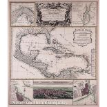
![[Gulf of Mexico and Caribbean Map], "Indiarum Occidentalium Tractus Littorales cum Insulis](https://portal-images.azureedge.net/auctions-2017/srne10025/images/2a829abc-41fa-492b-f754-ca5e48dac75c.jpg?w=155&h=155)
[Gulf of Mexico and Caribbean Map], "Indiarum Occidentalium Tractus Littorales cum Insulis Caribicis/ Pascaert van Westindien ende Caribise Eyland...
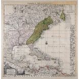
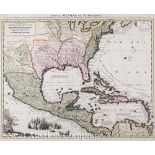
Santini, P. / Remondini, M., "Partie Meridionale de la Louisiane, avec la Floride, la Caroline et la
Santini, P. / Remondini, M., "Partie Meridionale de la Louisiane, avec la Floride, la Caroline et la Virginie", Venice, 1776/1784, second state, h...
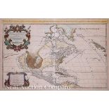
Covens and Mortier, "L'Amerique Septentrionale", Amsterdam, 1720, hand-colored, based on Sanson's
Covens and Mortier, "L'Amerique Septentrionale", Amsterdam, 1720, hand-colored, based on Sanson's 1674 example, 22 5/8 in. x 34 1/2 in
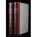
Latour, Arsene Lacarriere, HISTORICAL MEMOIR OF THE WAR IN WEST FLORIDA AND LOUISIANA IN 1814-
Latour, Arsene Lacarriere, HISTORICAL MEMOIR OF THE WAR IN WEST FLORIDA AND LOUISIANA IN 1814-1815. WITH AN ATLAS, Philadelphia, John Conrad, 1816...
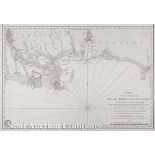
Schenk, Pieter, "Tabula Mexicae et Floridae, Terrarum Anglicarum, et anteriorum Americae Insularum; item cursuum et circuituum fluminis Mississipi...
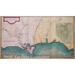
Sartine, Antoine, "Carte D'Une Partie des Cotes de la Floride et de la Louisiane...", Paris, 1778,
Sartine, Antoine, "Carte D'Une Partie des Cotes de la Floride et de la Louisiane...", Paris, 1778, Revolutionary War era map of the North Gulf Coa...
Homann Heirs / D'Anville, Jean Baptiste Bourguignon, "Mappa Geographica Complectens Indiae Occidentalis Carte des Isles de L'Amerique et de Plusie...
![[French Caribbean Sea Chart],"Carte Reduite des Debouquements de St. Domingue...", Paris, 1787, from](https://portal-images.azureedge.net/auctions-2017/srne10025/images/c9431ef3-e120-40fc-9cde-398a52ccff54.jpg?w=155&h=155)
[French Caribbean Sea Chart],"Carte Reduite des Debouquements de St. Domingue...", Paris, 1787, from
[French Caribbean Sea Chart],"Carte Reduite des Debouquements de St. Domingue...", Paris, 1787, from the atlas Le Pilote de l'Isle de Saint-Doming...
![[French Map of the Gulf of Mexico], "Carte du Golfe du Mexique dresse par Mr. Keller", Paris,](https://portal-images.azureedge.net/auctions-2017/srne10025/images/85fb9ba8-0286-4d06-8594-4dec54fd4253.jpg?w=155&h=155)
[French Map of the Gulf of Mexico], "Carte du Golfe du Mexique dresse par Mr. Keller", Paris,
[French Map of the Gulf of Mexico], "Carte du Golfe du Mexique dresse par Mr. Keller", Paris, Depot General de la Marine, 1843, hand-colored coppe...
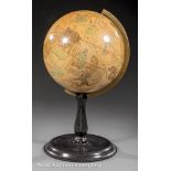
Fine American Ten-Inch Celestial Globe, c. 1870, marked "JOSLIN'S Ten Inch CELESTIAL GLOBE containing all the Stars to the fifth Magnitude, inclus...
Hermann, Binger, The Louisiana Purchase and Our Title West of the Rocky Mountains..., Washington,
Hermann, Binger, The Louisiana Purchase and Our Title West of the Rocky Mountains..., Washington, Government Printing Office, 1900, octavo, full c...
![[Exploration of the Red River], Marcy, Randolph B., Exploration of the Red River of Louisiana, in](https://portal-images.azureedge.net/auctions-2017/srne10025/images/48edfff1-6bda-4e29-ec66-060594e24b28.jpg?w=155&h=155)
[Exploration of the Red River], Marcy, Randolph B., Exploration of the Red River of Louisiana, in
[Exploration of the Red River], Marcy, Randolph B., Exploration of the Red River of Louisiana, in the Year 1852, Washington, 1853, octavo, cloth, ...
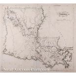
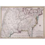
Carey, Mathew, "Louisiana", Philadelphia, 1814, from the General Atlas, hand-colored, one of the
Carey, Mathew, "Louisiana", Philadelphia, 1814, from the General Atlas, hand-colored, one of the earliest large format maps of the State of Louisi...
Mitchell, Samuel Augustus, "Mitchell's Travellers Guide through the United States", Philadelphia,
Mitchell, Samuel Augustus, "Mitchell's Travellers Guide through the United States", Philadelphia, 1832, first edition, hand-colored, tissue backed...
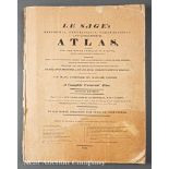
Le Sage's Historical, Genealogical, Chronological, and Geographical Atlas, 1818, London, second
Le Sage's Historical, Genealogical, Chronological, and Geographical Atlas, 1818, London, second edition, folio with 38 hand-colored charts (21) an...