Filtered by:
- Category
- List
- Grid
This auctioneer has chosen to not publish their results. Please contact them directly for any enquiries.
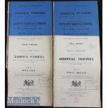

United Kingdom – The Arsenic Poisoning Epidemic 1900-1901 ‘Royal Commission on Arsenical Poisoning’ from the consumption of beer and other article...
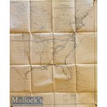
USA Maps - US Coast and Geodetic Survey Sketch of General Progress 30 June 1900^ 2 map^ Eastern
USA Maps - US Coast and Geodetic Survey Sketch of General Progress 30 June 1900^ 2 map^ Eastern and Western 32.5"x27" each^ folded (2)
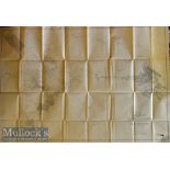
Alaska Map - Exploration in Alaska 1899 topography by W.J. Peters 1 to 10 miles 49"x32.75" plus
Alaska Map - Exploration in Alaska 1899 topography by W.J. Peters 1 to 10 miles 49"x32.75" plus margins. Shows the Yukon and Alaska Boundary^ the ...
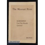
Americana – The Missouri River and Its Utmost Source Book by J V Brower 1897 2nd edition limited
Americana – The Missouri River and Its Utmost Source Book by J V Brower 1897 2nd edition limited to 500 copies^ 301 to 800^ this being No. 695^ ap...
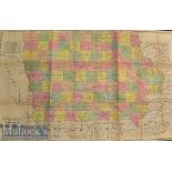
Americana – Township Map of the State of Iowa published by Henn Williams & Co and by R L Barnes^
Americana – Township Map of the State of Iowa published by Henn Williams & Co and by R L Barnes^ Philadelphia 1855 also bears the trade advert for...
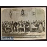
China – Signing of the Treaty Between England and China at Tien-Tsin on June 26 1858 original
China – Signing of the Treaty Between England and China at Tien-Tsin on June 26 1858 original engraving^ copy of the treaty text enclosed

Furniture Manufacturers (Scotland) Ltd 1930s Sales Catalogue. A 34 page catalogue illustrating their
Furniture Manufacturers (Scotland) Ltd 1930s Sales Catalogue. A 34 page catalogue illustrating their various household furniture much of which is ...
Suffolk Cloth Backed Folding Map c1835s - Attractively hand coloured in out-line. Printed by
Suffolk Cloth Backed Folding Map c1835s - Attractively hand coloured in out-line. Printed by Longmans^ Paternoster Row^ London. Folds out to 16½” ...
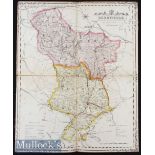
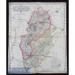
Derbyshire Map - Impressive Hand Coloured County Map Of Derbyshire c1840s - folding Cloth-backed map
Derbyshire Map - Impressive Hand Coloured County Map Of Derbyshire c1840s - folding Cloth-backed map showing Railways and Canals^ Distances of pri...
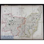
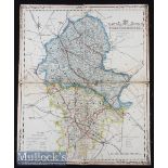
Nottinghamshire Map - Impressive Hand Coloured County Map of Nottinghamshire c1840s - folding
Nottinghamshire Map - Impressive Hand Coloured County Map of Nottinghamshire c1840s - folding Cloth-backed map showing Railways and Canals^ Distan...
Staffordshire Map - Impressive Hand Coloured County Map of Staffordshire c1840s - folding cloth-
Staffordshire Map - Impressive Hand Coloured County Map of Staffordshire c1840s - folding cloth-backed map showing Railways and Canals^ Distances ...

Views of The English Lakes^ c1850-70s - a 32 page small book with 12 attractive Baxter style three
Views of The English Lakes^ c1850-70s - a 32 page small book with 12 attractive Baxter style three colour views of Ulleswater^ Windermere and othe...
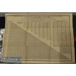
Table of the reciprocal Distances of the Principal Towns of Great Britain and Ireland published
Table of the reciprocal Distances of the Principal Towns of Great Britain and Ireland published Leeds at The Mercury Office by Edward Baines^ with...
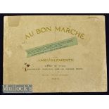
Bon Marche (leading Store in Paris^ still exists)^ 1914 Furniture Catalogue A most attractive 40
Bon Marche (leading Store in Paris^ still exists)^ 1914 Furniture Catalogue A most attractive 40 page furniture catalogue showing each item of fur...
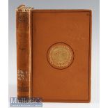
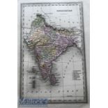
The Religions of India by A Barth 1891 - A 309 page book extensively detailing the principle
The Religions of India by A Barth 1891 - A 309 page book extensively detailing the principle Religions of India. In cloth board cover^ size 5¾” × ...
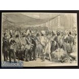
India – Reception of the Prince of Wales at Calcutta 1876 Engraving measures 51x36cm shows fold
India – Reception of the Prince of Wales at Calcutta 1876 Engraving measures 51x36cm shows fold line
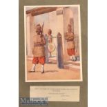
India & Punjab - Twelve original colour plates from The Armies of India 1911 painted by Major A C
India & Punjab - Twelve original colour plates from The Armies of India 1911 painted by Major A C Lovett^ displayed with accompanying text^ mounte...
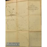
Voyages and Travels to India – 3x Large folding maps of Egypt c. 1809 issued in London for Viscount Valentia’s " Voyages and Travels to India^ Cey...
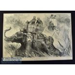
India - Nepal - The Prince of Wales Elephant Charged by a Tiger original double page engraving
India - Nepal - The Prince of Wales Elephant Charged by a Tiger original double page engraving 1876 after W. Simpson 50x34cm laid to card
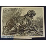
India - Le Roi Des Jungles (King of the Jungle) original engraving after painting by Bouverie
India - Le Roi Des Jungles (King of the Jungle) original engraving after painting by Bouverie Goddard 50x33cm published in L'Univers Illustre 1880...
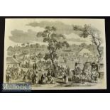
India - A Hindoo Fair original engraving 1858 probably after W Carpenter 36x25cm laid to card with
India - A Hindoo Fair original engraving 1858 probably after W Carpenter 36x25cm laid to card with descriptive text in reverse
Lander des Pendschab - Land of Punjab map - Rare original post Anglo Sikh wars map showing Maharajas
Lander des Pendschab - Land of Punjab map - Rare original post Anglo Sikh wars map showing Maharajas Gulab Singhs newly acquired Kashmir state und...
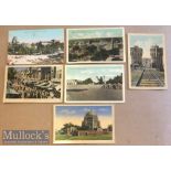
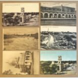
Collection of (6) printed colour postcards of scenes of Multan^ India c1900s. Views include Multan
Collection of (6) printed colour postcards of scenes of Multan^ India c1900s. Views include Multan city^ Bazaar^ the fort plus others.
Collection of (6) printed colour postcards of scenes of Multan^ India c1900s. Views include Multan
Collection of (6) printed colour postcards of scenes of Multan^ India c1900s. Views include Multan city^ Bazaar^ the fort plus others.
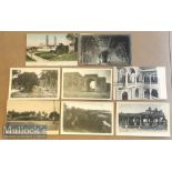
Collection of (8) printed & real photo postcards of Seringapatam^ India c1900s. Includes views of
Collection of (8) printed & real photo postcards of Seringapatam^ India c1900s. Includes views of the high mosque^ fort^ monuments plus others. ...
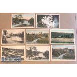
Collection of (8) printed postcards of Shillong^ India c1900s. Set includes views of the lake^ the
Collection of (8) printed postcards of Shillong^ India c1900s. Set includes views of the lake^ the cricket ground^ military lines plus others.
Collection of (6) printed postcards of Secunderabad^ India c1900s. Set includes views of James
Collection of (6) printed postcards of Secunderabad^ India c1900s. Set includes views of James bazaar street^ railway station^ tomb plus others
Collection of (10) real photo & printed postcards of Jhansi India c1900s set includes views of
Collection of (10) real photo & printed postcards of Jhansi India c1900s set includes views of memorial^ military barracks^ the fort^ greetings ca...
Collection of (10) printed postcards of Kashmir^ India c1900s. Set includes views of the temple at
Collection of (10) printed postcards of Kashmir^ India c1900s. Set includes views of the temple at martand^ rope bridge^ nishat bagh^ mosque & cit...
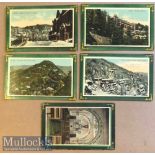
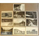
Collection of (10) real photo & printed postcards of the N.W.F.P^ India c1900s. Set includes views
Collection of (10) real photo & printed postcards of the N.W.F.P^ India c1900s. Set includes views of the Khyber pass^ Afridi family^ Attock bridg...
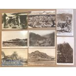
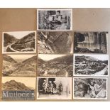
Collection of (15) real photo & printed postcards of N.W.F.P^ India c1900s. Set includes views of
Collection of (15) real photo & printed postcards of N.W.F.P^ India c1900s. Set includes views of landikotal fort^ pathans selling grain^ Peshawar...
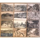
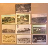
Collection of (20) printed postcards of Simla^ India c1900s. Includes views of the mall^ viceregal
Collection of (20) printed postcards of Simla^ India c1900s. Includes views of the mall^ viceregal lodge^ boarding school^ on the road to theog^ m...
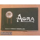
Postcard book of Agra^ India (12) c1900s published by pasha & co Agra. All cards present includes
Postcard book of Agra^ India (12) c1900s published by pasha & co Agra. All cards present includes views of famous monuments such a Taj Mahal^ Jaha...
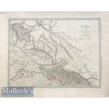
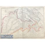
India & Punjab - c1850s Map of Punjab - showing dominions of Ranjit Singh & protected Sikh states.
India & Punjab - c1850s Map of Punjab - showing dominions of Ranjit Singh & protected Sikh states. Published in London by Charles knight Hand colo...
Map of India c1840s showing occupation of states - The Sikh kingdom of Punjab & protected Sikh
Map of India c1840s showing occupation of states - The Sikh kingdom of Punjab & protected Sikh states being the largest independent state in Hindu...
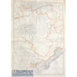
Map of India c857^ the Punjab & Cashmere Post Sikh wars map showing the Sikh kingdom & Kashmir state
Map of India c857^ the Punjab & Cashmere Post Sikh wars map showing the Sikh kingdom & Kashmir state after it was purchased by Maharaja Gulab Sing...
Map of India c1857 Nagpoor & Hyderabad Published by Day & Sons. Hand coloured c1857. Dimensions 48 x
Map of India c1857 Nagpoor & Hyderabad Published by Day & Sons. Hand coloured c1857. Dimensions 48 x 34 cm ...[more]
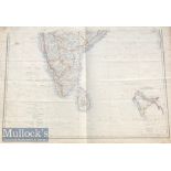
19th century Map of Southern India Published by Day & Sons. Hand coloured c1857. Dimensions 48 x
19th century Map of Southern India Published by Day & Sons. Hand coloured c1857. Dimensions 48 x 34 cm ...[more]
Original print showing the Town of Amritsar the Sikhs holy city by Mortimer Menpes. c1900s.
Original print showing the Town of Amritsar the Sikhs holy city by Mortimer Menpes. c1900s. Dimensions 16 x 14 cm
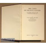
India & Punjab - Punjab Land Of The Five Rivers A Economic History Of The Punjab From The Earliest
India & Punjab - Punjab Land Of The Five Rivers A Economic History Of The Punjab From The Earliest Times To 1890 Book Author Hugh Trevaskis^ OUP^ ...