Filtered by:
- Category
- List
- Grid
This auctioneer has chosen to not publish their results. Please contact them directly for any enquiries.
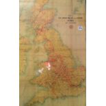

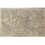
Map of The London Midland and Scottish Railway - and connections, printed McCorquodale & Co,
Map of The London Midland and Scottish Railway - and connections, printed McCorquodale & Co, colour map, framed measures 59x94cm approx. creases p...
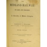
The Midland Railway By F.S. Williams. 1878. An compendious 678 page publication detailing the then
The Midland Railway By F.S. Williams. 1878. An compendious 678 page publication detailing the then construction, maintenance and present operatio...
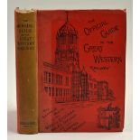
The Official Guide to the Great Western Railway Circa 1898 Book - A comprehensive 418 page book with
The Official Guide to the Great Western Railway Circa 1898 Book - A comprehensive 418 page book with many maps, Giving in some detail photographs ...
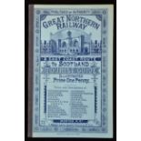
Great Northern Railway & East Coast Route To Scotland. Tourist Guide. Circa 1880s. A fine 40 page
Great Northern Railway & East Coast Route To Scotland. Tourist Guide. Circa 1880s. A fine 40 page publication with 28 well engraved views of place...
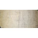
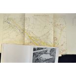
Cannock Road/Stafford Road Bridge Railway Gradient Original Plans hand drawn on linen, No726,
Cannock Road/Stafford Road Bridge Railway Gradient Original Plans hand drawn on linen, No726, measures 56x100cm approx.

Aviation - Deutsche Lufthansa - Winter Time Table October 1938 - March 1939. Folds out to large
Aviation - Deutsche Lufthansa - Winter Time Table October 1938 - March 1939. Folds out to large poster size showing plan style map of their extens...

United Air Lines 1936 Time Table - An attractive 12 page time table for the airlines "Overnight
United Air Lines 1936 Time Table - An attractive 12 page time table for the airlines "Overnight Coast to Coast" service with 8 photographs of thei...
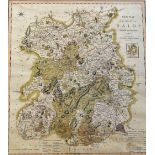
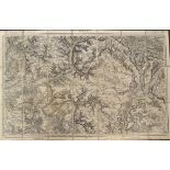
19th Century 'Salop' by C. Smith Map - a new map of the County of Salop Divided into Hundreds,
19th Century 'Salop' by C. Smith Map - a new map of the County of Salop Divided into Hundreds, London, printed for C. Smith No172 Strand, January ...
Map - Upper Congo 1935 second Edition Map published at the War Office 1919, a projection of the
Map - Upper Congo 1935 second Edition Map published at the War Office 1919, a projection of the International Map, with folds and creases apparent...
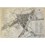
Worcester c.1709 Map depicting a plan of the City and Suburbs of Worcester, appears in good condition, framed, measures 52 x 41cm approx.
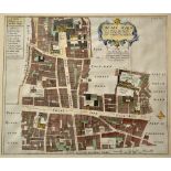
'Cheape Ward' - Guildhall Cheapside Poultry - London Map - appears engraved with coloured parts c.
'Cheape Ward' - Guildhall Cheapside Poultry - London Map - appears engraved with coloured parts c.18th Century, framed measures 50x44cm approx.
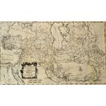
The Expedition of Alexander the Great - Map - 'Alexander's Expedition Drawn for Rollin's Antient
The Expedition of Alexander the Great - Map - 'Alexander's Expedition Drawn for Rollin's Antient History by Mr D'Anville the French King's Geograp...
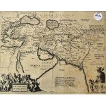
Alexander The Great Map - 'Alexandri Magni Macedonis Expeditio.' - depicting the region covered by
Alexander The Great Map - 'Alexandri Magni Macedonis Expeditio.' - depicting the region covered by Alexander the Great illustrating the region bas...
1856 Map of Lorient - scale 1/520,000, with French detail, Depot de la Guerre par F. Chardon
1856 Map of Lorient - scale 1/520,000, with French detail, Depot de la Guerre par F. Chardon
1852 Map of Paris - scale 1/520,000 with French detail, Depot de la Guerre
1836 Map of Rouen - with French detail, Depot de la Guerre

World War II - Interesting Selection of Atlases to include 1939 Handatlas for the Hitler Youth, in
World War II - Interesting Selection of Atlases to include 1939 Handatlas for the Hitler Youth, in cloth board, covers slightly worn otherwise pag...
1940 'Operation Sea Lion' - German Invasion Booklet of the South Coast - contains information and
1940 'Operation Sea Lion' - German Invasion Booklet of the South Coast - contains information and maps regarding the region, appears in G condition
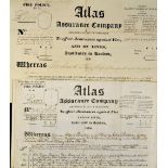
1870 Atlas Assurance Company Fire Policy - dated 26th January, Panton Family, brewers, maltsters and
1870 Atlas Assurance Company Fire Policy - dated 26th January, Panton Family, brewers, maltsters and spirit merchants, printed and completed in ha...
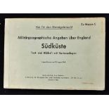
WWII - Operation Sea Lion - The Nazi Invasion of Britain - Militärgeographische Objektkarten for the
WWII - Operation Sea Lion - The Nazi Invasion of Britain - Militärgeographische Objektkarten for the South East and London, plus North East of Eng...