
Refine your search
Filtered by:
- Category
- List
- Grid
A subscription to the Price Guide is required to view results for auctions ten days or older. Click here for more information
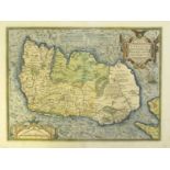

1579 Map of Ireland by Ortelius. A hand-coloured, engraved map, Eyrn Hiberniae, Britannicae, Insulae Nova Descripto, Irlandt, orientated to the We...
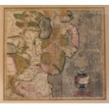
1619 Map of East Ulster by Gerard Mercator, hand-coloured, engraved map, Ultoniae Orientalis,
1619 Map of East Ulster by Gerard Mercator, hand-coloured, engraved map, Ultoniae Orientalis, 15" x 13¾" (38 x 35cm) framed; together with an 18th...
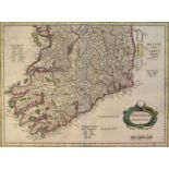
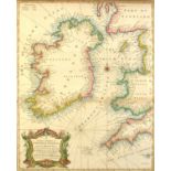
1636 Map of the southern half of Ireland by Mercator and 1759 Plans of the Principal Ports, Towns and Harbours of Ireland, for Mr Tindall's Conti...
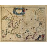
1650 Map of the Arctic by William Janszoon Blaeu. A hand-coloured, engraved map, Regiones Sob Polo Arctico,16¼" x 20¾" (41 x 52cm) framed.
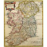
1695, The Kingdom of Ireland, by Robert Morden. A hand-coloured, engraved map, from Camden's Britannia, 1695, with Newry spelt 'Nury' reverse blan...
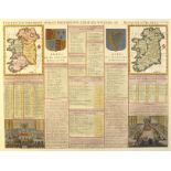
1708 & 1766 Maps of Ireland, incorporating the earliest recorded view of the Irish Parliament,
1708 & 1766 Maps of Ireland, incorporating the earliest recorded view of the Irish Parliament, two and-coloured, engraved maps, Carte Du Gouvernme...
1744 A Correct Chart of St.
1744 A Correct Chart of St. George's Channel and the Irish Sea and Tallis' map of Britain and Ireland, a hand-coloured engraved chart 'including ...
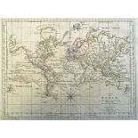
1789 Chart of the World, by Samuel Dunn. An engraved chart, 'on Mercator's Projection with the tracks and discoveries of the Latest Circumnavigato...
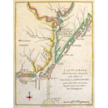
1781 Map of Cape Fear showing the battle dispositions of Cornwallis' Army. A hand coloured engraved map of Cape Fear River with the Counties Adjac...
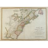
1790 Map of the Eastern seaboard of North America, by Jean Baptiste Bourguignon d'Anville. A hand-coloured engraved map, A Particular Map of the A...
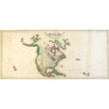
Circa 1830 Map of North America by Lizars, Edinburgh. A hand-coloured engraved map of North Americas published by William Hole Lizars. Showing unc...
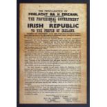
Circa 1920 Broadsheet, Proclamation of Poblacht na hÉireann, letterpress printed to closely resemble the 1916 Proclamation, 15½ (39cm) x 10¼" (26c...

Inglis, Henry D. Ireland in 1834. A Journey throughout Ireland, during the Spring, Summer and Autumn of 1834.Whittaker & Co., London, 1835. 2nd ed...
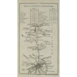
Taylor & Skinner's Maps of the Roads of Ireland, Surveyed 1777. G. Nicol, London, and W. Wilson, Dublin, 14th November 1778. First edition. 288 pa...

Virgil. Maronis Opera nunc emendatiora. Elzeviriana edition.Lugd. Batavor. Ex officina Elzeviriana, 1636, 32mo, [40], 411, [43]pp index, engraved ...