Filtered by:
- Category
- List
- Grid
A subscription to the Price Guide is required to view results for auctions ten days or older. Click here for more information
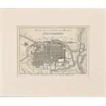

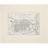
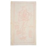
AN ANTIQUE PRINTED MAP BY J. N. BELLIN / J. VAN SCHLEY, La Haye 1752. PLAN DE LA VILLE DE MEACO.
AN ANTIQUE PRINTED MAP BY J. N. BELLIN / J. VAN SCHLEY, La Haye 1752. PLAN DE LA VILLE DE MEACO. Copperplate Uncoloured. A well engraved and detai...
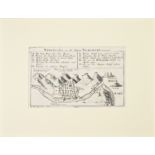
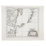
AN ANTIQUE PRINTED MAP BY J. STOCKLEIN, Augsburg 1726. Nagasaki So Sie Sineser Tschangki Nennen.
AN ANTIQUE PRINTED MAP BY J. STOCKLEIN, Augsburg 1726. Nagasaki So Sie Sineser Tschangki Nennen. Copperplate Uncoloured. This detailed and uncommo...
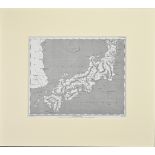
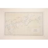
AN ANTIQUE PRINTED MAP 'JAPAN' BY A. ARROWSMITH, London 1802. Steel plate Uncoloured. An interesting, clear and detailed map of Japan, excluding H...
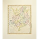
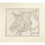
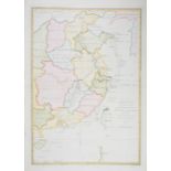
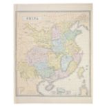
ANTIQUE PRINTED MAP 'CHINA' BY J. & C. WALKER, London 1843 - 1844. Attractive hand-colour. This
ANTIQUE PRINTED MAP 'CHINA' BY J. & C. WALKER, London 1843 - 1844. Attractive hand-colour. This interesting and detailed map of China was publishe...
AN ANTIQUE PRINTED MAP BY J. N. BELLIN, Paris 1752. PLAN DE LA VILLE DE MEACO. Copperplate Uncoloured. A well engraved and detailed plan of the po...
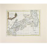
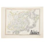
AN ANTIQUE PRINTED MAP 'L'IMPERO DEL GIAPON' BY A. ZATTA, Venice 1785. Copperplate Coloured. A
AN ANTIQUE PRINTED MAP 'L'IMPERO DEL GIAPON' BY A. ZATTA, Venice 1785. Copperplate Coloured. A highly detailed map of Japan, showing provinces, ma...
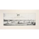
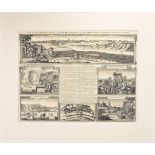
AN ANTIQUE PRINTED MAP 'DE STADT OSACCO', Leiden 1669- BY A. MONTANUS. Copperplate Uncoloured. A
AN ANTIQUE PRINTED MAP 'DE STADT OSACCO', Leiden 1669- BY A. MONTANUS. Copperplate Uncoloured. A fascinating and detailed panoramic view of Osaka ...
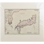
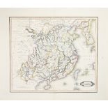
ANTIQUE PRINTED MAP 'CHINA' BY W. LIZARS, Edinburgh 1842. With attractive outline colour. This
ANTIQUE PRINTED MAP 'CHINA' BY W. LIZARS, Edinburgh 1842. With attractive outline colour. This detailed map of China includes text giving measurem...
ANTIQUE PRINTED MAP BY H. A. CHATELAIN 'HABILLEMENS D'HOMMES & DE FEMMES DIVERSE PROVINCES DE LA
ANTIQUE PRINTED MAP BY H. A. CHATELAIN 'HABILLEMENS D'HOMMES & DE FEMMES DIVERSE PROVINCES DE LA CHINE', Amsterdam c.1720. Copperplate Uncoloured,...
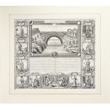
AN ANTIQUE PRINTED MAP BY H. A. CHATELAIN, Amsterdam 1719. VUE ET DESCRIPTION DE LA VILLE DE MEACO
AN ANTIQUE PRINTED MAP BY H. A. CHATELAIN, Amsterdam 1719. VUE ET DESCRIPTION DE LA VILLE DE MEACO CAPITALE DU JAPON...; Copperplate Uncoloured. F...
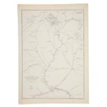
ANTIQUE PRINTED MAP BY SIR JOHN BARROW, London 1797. A chart on Mercator's Projection containing the
ANTIQUE PRINTED MAP BY SIR JOHN BARROW, London 1797. A chart on Mercator's Projection containing the Track and surroundings of the Lion, the Hindo...
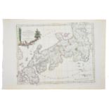
AN ANTIQUE PRINTED MAP 'IAPONIA REGNUM' BY M. MARTINI, J. BLAEU, P. MORTIER, Amsterdam 1655-c.
AN ANTIQUE PRINTED MAP 'IAPONIA REGNUM' BY M. MARTINI, J. BLAEU, P. MORTIER, Amsterdam 1655-c.1700. Copperplate, original outline colour. An elega...
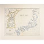
ANTIQUE PRINTED MAP BY G. PHILIP COREA AND JAPAN London c. 1859. Lithograph, original Colour. This
ANTIQUE PRINTED MAP BY G. PHILIP COREA AND JAPAN London c. 1859. Lithograph, original Colour. This interesting map of Korea and Japan was publishe...
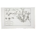
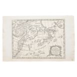
ANTIQUE PRINTED MAP BY F. F. DE LA PEROUSE, Paris 1797. Carte des Decouvertes, Faites en 1787 dans
ANTIQUE PRINTED MAP BY F. F. DE LA PEROUSE, Paris 1797. Carte des Decouvertes, Faites en 1787 dans les Mers de Chine et De Tartaire... 2E Feuille;...
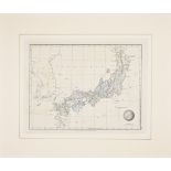
AN ANTIQUE PRINTED MAP 'JAPAN' BY A. ARROWSMITH, London 1828. A lithograph engraving, original
AN ANTIQUE PRINTED MAP 'JAPAN' BY A. ARROWSMITH, London 1828. A lithograph engraving, original colour. A clear and highly detailed map of Japan, w...
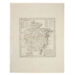
ANTIQUE PRINTED MAP 'ASIE PARTIE DE LA CHINE NO. 59' BY P. M. VANDERMAELEN, Brussels 1827. Lithograph Original outline colour. Philippe Vandermael...
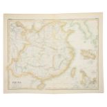
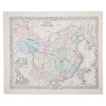
ANTIQUE PRINTED MAP 'CHINA' BY GEORGE PHILLIP & SON, London c1859. Lithograph Original Colour.
ANTIQUE PRINTED MAP 'CHINA' BY GEORGE PHILLIP & SON, London c1859. Lithograph Original Colour. This interesting map of China was published in "The...
AN ANTIQUE PRINTED MAP BY J. B. DU HALDE / E. BOWEN, London 1738. PROVINCE V. CHE-KYANG; DRAWN ON THE SPOT ... IN THE YEAR 1714. Copperplate Uncol...
ANTIQUE PRINTED MAP BY W. LIZARS 'CHINA' Edinburgh c1842. Steel plate Original outline colour. An
ANTIQUE PRINTED MAP BY W. LIZARS 'CHINA' Edinburgh c1842. Steel plate Original outline colour. An attractive and detailed map of China, including ...
ANTIQUE PRINTED MAP 'CHINA' BY G. H. SWANSTON & J. BARTHOLOMEW, Edinburgh, London & Dublin A
ANTIQUE PRINTED MAP 'CHINA' BY G. H. SWANSTON & J. BARTHOLOMEW, Edinburgh, London & Dublin A Fullarton & Co. C.1860. Steel plate coloured. An attr...
AN ANTIQUE PRINTED MAP BY E. WELLER, London c. 1860. MAP OF THE COUNTRY BETWEEN PE-KING & THE GULF
AN ANTIQUE PRINTED MAP BY E. WELLER, London c. 1860. MAP OF THE COUNTRY BETWEEN PE-KING & THE GULF OF PE-CHILI. Lithograph Original outline colour...
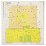
AN ANTIQUE SKETCH MAP OF PEKING DRAWN FOR CROW'S 'HANDBOOK FOR CHINA' BY C. CROW, New York, Dodd,
AN ANTIQUE SKETCH MAP OF PEKING DRAWN FOR CROW'S 'HANDBOOK FOR CHINA' BY C. CROW, New York, Dodd, Mead & Co. 1933. Lithograph Coloured. An uncommo...
AN ANTIQUR PRINTED MAP BY A. ZATTA, Venice 1785. L'IMPERO DEL GIAPON...; Copperplate Original
AN ANTIQUR PRINTED MAP BY A. ZATTA, Venice 1785. L'IMPERO DEL GIAPON...; Copperplate Original outline colour. Antonio Zatta's map of Japan is a go...
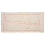
AN ANTIQUE PRINTED MAP BY W. F. MAYERS, London / Hong Kong 1867. FROM TUNGCHOW TO PEKING. Lithograph
AN ANTIQUE PRINTED MAP BY W. F. MAYERS, London / Hong Kong 1867. FROM TUNGCHOW TO PEKING. Lithograph uncoloured. William Frederick Mayers was one ...
AN ANTIQUE PRINTED MAP 'CHINA' BY J. WYLD / J. THOMSON, London 1825. Copperplate Original colour. An
AN ANTIQUE PRINTED MAP 'CHINA' BY J. WYLD / J. THOMSON, London 1825. Copperplate Original colour. An attractive nineteenth-century map of China wi...
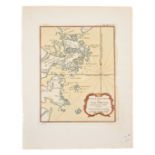
AN ANTIQUE PRINTE MAP BY J. N. BELLIN C.1764. CARTE DE L'ISLE DE CHEU CHAN OU ISLE DE CHUSAN De la
AN ANTIQUE PRINTE MAP BY J. N. BELLIN C.1764. CARTE DE L'ISLE DE CHEU CHAN OU ISLE DE CHUSAN De la Province de Che-kiang. Avec les Costes et Isles...
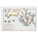
AN ANTIQUE PRINTED MAP BY J. N. BELLIN, Paris 1764. CARTE DES ISLES QUI SONT A ENTREE DE LA RIVIERE DE CANTON. Copperplate coloured. An attractive...
AN ANTIQUE PRINTED MAP BY J. N. BELLIN, c.1764. ISLE DE CHEU CHAN OU ISLE CHUSAN avec les Costes
AN ANTIQUE PRINTED MAP BY J. N. BELLIN, c.1764. ISLE DE CHEU CHAN OU ISLE CHUSAN avec les Costes et Isles voisines. Copperplate Original Colour. D...
AN ANTIQUE PRINTED MAP BY J. N. BELLIN, C.1764 -. CARTE, DE L'ISLE DE CHEU CHAN OU ISLE DE CHUSAN De
AN ANTIQUE PRINTED MAP BY J. N. BELLIN, C.1764 -. CARTE, DE L'ISLE DE CHEU CHAN OU ISLE DE CHUSAN De la Province de Che-kiang Avec les Costes et I...
AN ANTIQUE PRINTED 'COLTON'S CHINA' BY J. H. COLTON, New York 1855 - c.1860. Lithograph Original
AN ANTIQUE PRINTED 'COLTON'S CHINA' BY J. H. COLTON, New York 1855 - c.1860. Lithograph Original colour. An attractive and detailed map, published...
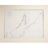
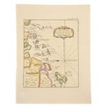
AN ANTIQUE PRINTED MAP BY LAURENT, Paris c.1780. CARTE DES ISLES KOU RILES DAPRES LE CARTE RUSE.
AN ANTIQUE PRINTED MAP BY LAURENT, Paris c.1780. CARTE DES ISLES KOU RILES DAPRES LE CARTE RUSE. Copperplate Coloured. Detailed and attractively c...
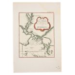
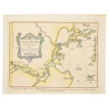
AN ANTIQUE PRINTED MAP BY J. N. BELLIN, C.1764. CARTE DE LA BAYE DEHISCE et des Entrees de la
AN ANTIQUE PRINTED MAP BY J. N. BELLIN, C.1764. CARTE DE LA BAYE DEHISCE et des Entrees de la Riviere de Chang, Dans laProvince de Fokine, en Chin...
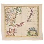
AN ANTIQUE PRINTED MAP BY T. BOWEN, London 1775. THE NORTHERN ARCHIPELAGO ... IN THE SEAS OF
AN ANTIQUE PRINTED MAP BY T. BOWEN, London 1775. THE NORTHERN ARCHIPELAGO ... IN THE SEAS OF KAMCHATKA...; Copperplate Uncoloured. Engraved by Tho...
AN ANTIQUE PRINTED MAP 'JAPAN INLAND SEA' London C.1870-; Lithograph Original colour. A finely
AN ANTIQUE PRINTED MAP 'JAPAN INLAND SEA' London C.1870-; Lithograph Original colour. A finely produced map of southern Japan, focusing on the are...
AN ANTIQUE PRINTED MAP BY W. F. MAYERS, London / Hong Kong 1867. MAP OF FOOCHOW. Lithograph uncoloured. William Frederick Mayers was one of a numb...
AN ANTIQUE PRINTED MAP BY N. BELLIN / J. VAN SCHLEY, Paris / Amsterdam c.1770. CARTE DE LA BAYE
AN ANTIQUE PRINTED MAP BY N. BELLIN / J. VAN SCHLEY, Paris / Amsterdam c.1770. CARTE DE LA BAYE DEHISCE ...; Copperplate coloured. This chart for ...
AN ANTIQUE PRINTED MAP BY LAURENT, Paris c.1780. CARTE DES ISLES KOU RILES DAPRES LE CARTE RUSSE.
AN ANTIQUE PRINTED MAP BY LAURENT, Paris c.1780. CARTE DES ISLES KOU RILES DAPRES LE CARTE RUSSE. Copperplate Uncoloured. Detailed and early map s...