
Filtered by:
- Category
- List
- Grid
A subscription to the Price Guide is required to view results for auctions ten days or older. Click here for more information

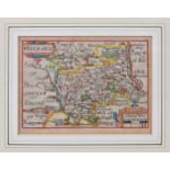
Speed, John, engraved by Jodocus Hondius, The Countie Pallatine of Lancaster Described and Divided
Speed, John, engraved by Jodocus Hondius, The Countie Pallatine of Lancaster Described and Divided into Hundreds 1610, hand coloured engraved map ...
Two 17th century engraved miniature county maps, Lancashire (Lancaster) and Middlesex (Midle-Sex),
Two 17th century engraved miniature county maps, Lancashire (Lancaster) and Middlesex (Midle-Sex), hand coloured, scale 6 miles to 1in., 3½ x 4 7/...
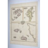
An early 19th century Channel Islands map, titled ‘Remote British Isles’, including Jersey and
An early 19th century Channel Islands map, titled ‘Remote British Isles’, including Jersey and Guernsey, the Scilly Isles and the Shetland Isles, ...
Gerard Mercator (Flemish, 1512-1594), Anglesey, Garnesay, Jarsay and Wight Vectis, c.1620, four hand
Gerard Mercator (Flemish, 1512-1594), Anglesey, Garnesay, Jarsay and Wight Vectis, c.1620, four hand coloured engraved maps on one sheet, Latin te...
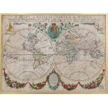
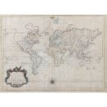
Blome, Richard, A Mapp or Generall Carte of the World, Designed in two Plaine Hemisphers by Monsieur
Blome, Richard, A Mapp or Generall Carte of the World, Designed in two Plaine Hemisphers by Monsieur Sanson, Geograph'r to the French King and ren...
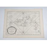
![Jansson, Jan, British Islands - Holy Island, Garnsey, Farne [and] Jarsey, c.1680, engraved map](https://portal-images.azureedge.net/auctions-2022/srmart10072/images/f62faf49-94fd-4e1f-858d-aebe00f45550.jpg?w=155&h=155)
Jansson, Jan, British Islands - Holy Island, Garnsey, Farne [and] Jarsey, c.1680, engraved map
Jansson, Jan, British Islands - Holy Island, Garnsey, Farne [and] Jarsey, c.1680, engraved map with outline colouring, four maps on one sheet, eac...
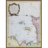
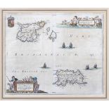
Bellin, Jacques Nicolas (1703-1772), 'Carte Reduite des Isles de Jersey, Grenesey et d'Aurigny',
Bellin, Jacques Nicolas (1703-1772), 'Carte Reduite des Isles de Jersey, Grenesey et d'Aurigny', pub. Paris 1757, copper engraving with decorative...
Jacques Nicolas Bellin (French, 1703-1772), a pair of uncoloured engraved charts with cartouche,
Jacques Nicolas Bellin (French, 1703-1772), a pair of uncoloured engraved charts with cartouche, comprising Carte de L`Isle de Grenesey, and Carte...
Bellin, Jacques Nicolas (1703-1772), Essay d`une Carte Reduite Contenant les Parties Connues du
Bellin, Jacques Nicolas (1703-1772), Essay d`une Carte Reduite Contenant les Parties Connues du Globe Terrestre..., large engraved world chart on ...
Le Rouge, George Louis, Les Isles Britanniques ou les Royaumes d'Angleterre, d'Ecosse et d'Irlande
Le Rouge, George Louis, Les Isles Britanniques ou les Royaumes d'Angleterre, d'Ecosse et d'Irlande Divisees par Provinces, pub. Paris, 1744, engra...
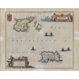
Three Channel Islands maps, comprising Sarnia Insula by Johannes Blaeu, 17 x 21¼in. (43.2 x 54cm.), restorations; a Map of the Four Islands by Joh...
Joan Blaeu (1596-1673), Map of Jersey and Guernsey, inscribed "Sarnia Insula, Vulgo Garnsey et
Joan Blaeu (1596-1673), Map of Jersey and Guernsey, inscribed "Sarnia Insula, Vulgo Garnsey et Insula Caesarea, Vernacule Jarsey", hand coloured e...
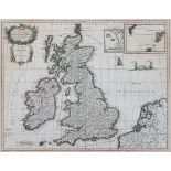
After Henri Abraham Chatelain (French, 1684-1743), Pair of French maps of England, "Nouvelle Carte
After Henri Abraham Chatelain (French, 1684-1743), Pair of French maps of England, "Nouvelle Carte du Gouvernement Civil, d'Angleterre et de celuy...
A collection of vintage / antique sea charts, to include one of 'The Channel Islands and Adjacent
A collection of vintage / antique sea charts, to include one of 'The Channel Islands and Adjacent Coast of France, compiled from latest informatio...
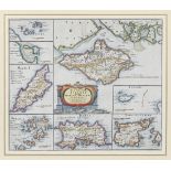
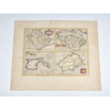
Robert Morden (fl.1668-1703), The Smaller Islands in the British Ocean depicting Farne Island,
Robert Morden (fl.1668-1703), The Smaller Islands in the British Ocean depicting Farne Island, Holy Island, Isle of Man, Scilly Islands, Jersey, G...
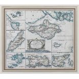
Robert Morden (fl.1668-1703), The Smaller Islands in the British Ocean depicting Farne Island,
Robert Morden (fl.1668-1703), The Smaller Islands in the British Ocean depicting Farne Island, Holy Island, Isle of Man, Scilly Islands, Jersey, G...
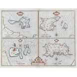
John Speede (British, 1552-1629), engraved quartered map of Holy Iland, Garnsey, Farne and Jarsey,
John Speede (British, 1552-1629), engraved quartered map of Holy Iland, Garnsey, Farne and Jarsey, with hand colouring, compass roses and armorial...
Walter Gilbert Wiles (British, 1875-1966), Coast near Cape Town, South Africa. pastel, signed
Walter Gilbert Wiles (British, 1875-1966), Coast near Cape Town, South Africa. pastel, signed lower right. 13 ¼ x 19 ¼in. (33.6 x 49cm.). * Acid f...
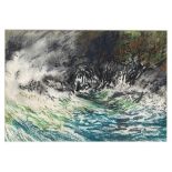
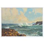
William John Caparne (British, 1855-1940), Turbulent seas pastel, unsigned 7½ x 10 7/8in. (19 x 27.
William John Caparne (British, 1855-1940), Turbulent seas pastel, unsigned 7½ x 10 7/8in. (19 x 27.6cm.) * Acidic mount. Good overall – some cockl...