Filtered by:
- Category
- List
- Grid
A subscription to the Price Guide is required to view results for auctions ten days or older. Click here for more information
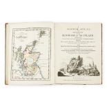

Armstrong, Mostyn JohnA Scotch Atlas. London: Laurie & Whittle, 1794. 8vo, 30 hand-coloured engraved
Armstrong, Mostyn JohnA Scotch Atlas. London: Laurie & Whittle, 1794. 8vo, 30 hand-coloured engraved maps, contemporary half-calf, a little rubbed...

Ayrshire, River Doon - Ordnance Survey7 large double-sheet engraved maps, showing the Course of
Ayrshire, River Doon - Ordnance Survey7 large double-sheet engraved maps, showing the Course of the River Doon, numbered 58, 59, 53, 52 46, 40, 39...
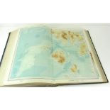
Blaeu, Willem[Geographiae Blaeuaniae... Amsterdam: Jan Blaeu, 1654. Volume VI, Book XII only [
Blaeu, Willem[Geographiae Blaeuaniae... Amsterdam: Jan Blaeu, 1654. Volume VI, Book XII only [Scotland only]. Folio (500 x 350mm.) hand-coloured e...
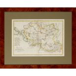
Bonne, RigobertTartarie Independante. Paris, 1787, 35.5 x 25cm, hand-coloured engraved map, framed
Bonne, RigobertTartarie Independante. Paris, 1787, 35.5 x 25cm, hand-coloured engraved map, framed and glazed; [Speed, John] Descripto Sabavdie. [...
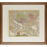
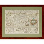
Homann, Johann BaptisteFluviorum in Europa Principis Danubii Cum Adiacentiibus Regnis nec non totius
Homann, Johann BaptisteFluviorum in Europa Principis Danubii Cum Adiacentiibus Regnis nec non totius Graeciae Et Archipelagi Novissima Tabula. Nur...
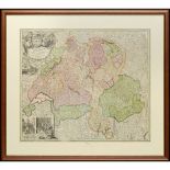
Homann, Johann BaptistePotentissimae Helvetiorum Reipublicae Cantones Trediecim cum Foederatis.
Homann, Johann BaptistePotentissimae Helvetiorum Reipublicae Cantones Trediecim cum Foederatis. Nuremburg, 1710, 48.5 x 58cm, hand-coloured engrav...
![Hondius, JodocusAmerica. [Amsterdam, 1606 or later], 395 x 523mm., hand-coloured engraved map,](https://portal-images.azureedge.net/auctions-2018/srly10173/images/23ceb2ab-8afd-4e98-8bf4-03dbb95475c6.jpg?w=155&h=155)
Hondius, JodocusAmerica. [Amsterdam, 1606 or later], 395 x 523mm., hand-coloured engraved map,
Hondius, JodocusAmerica. [Amsterdam, 1606 or later], 395 x 523mm., hand-coloured engraved map, strengthened on verso at centre fold, 2 vertical te...
![[Kitchin, Thomas][Geographia Scotiae: being new and correct maps of all the counties and islands](https://portal-images.azureedge.net/auctions-2018/srly10173/images/78356b13-1d61-4f4a-a9ad-94472ce7bc5e.jpg?w=155&h=155)
[Kitchin, Thomas][Geographia Scotiae: being new and correct maps of all the counties and islands
[Kitchin, Thomas][Geographia Scotiae: being new and correct maps of all the counties and islands in the kingdom of Scotland ... with a general map...
![Lewis, SamuelA Map of Scotland Divided into Counties. London, [c.1840], in 3 divisions (Northern,](https://portal-images.azureedge.net/auctions-2018/srly10173/images/e97dc1f2-dd72-47c9-87e9-b880c6eee08c.jpg?w=155&h=155)
Lewis, SamuelA Map of Scotland Divided into Counties. London, [c.1840], in 3 divisions (Northern,
Lewis, SamuelA Map of Scotland Divided into Counties. London, [c.1840], in 3 divisions (Northern, Central and Southern), each in original red moro...
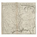
Louisiana - De L'Isle, GuillaumeCarte de la Louisiane et du Cours du Mississippi, dressée sur un
Louisiana - De L'Isle, GuillaumeCarte de la Louisiane et du Cours du Mississippi, dressée sur un grand nombre de Memoires entrau tres sur ceux de ...
MercatorCyprus Ins. Amsterdam 1633, 35 x 49cm, hand-coloured engraved map, framed and glazed ...[more]
Merchant CompanyLanded Estates, Notes and Plans for the use of the Governors. Edinburgh: Merchants' Hall, 1891. 8vo, 14 linen backed maps, contemp...
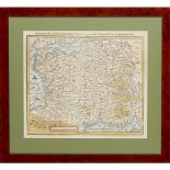
Munster, SebastianDas Gantzte Frankreich/so vorzeiten Narbonensis, Lugdunensis, Belgica und Celtica ist genennt worden. Basel, 1614, 33.5 x 38.5cm...
North America - Arrowsmith, AaronA Map Exhibiting all the New Discoveries in the Interior Parts of
North America - Arrowsmith, AaronA Map Exhibiting all the New Discoveries in the Interior Parts of North America, Inscribed by Permission to the H...
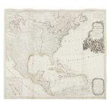
North America Map - Robert SayerA new map of North America, with the West India Islands. Divided
North America Map - Robert SayerA new map of North America, with the West India Islands. Divided according to the preliminary articles of peace, s...
![Oliver & BoydNew Travelling Map of Scotland... Edinburgh: Oliver & Boyd, [n.d.] Small 8vo, 55pp.](https://portal-images.azureedge.net/auctions-2018/srly10173/images/3f71d929-90de-496d-833b-911f3daca91e.jpg?w=155&h=155)
Oliver & BoydNew Travelling Map of Scotland... Edinburgh: Oliver & Boyd, [n.d.] Small 8vo, 55pp.
Oliver & BoydNew Travelling Map of Scotland... Edinburgh: Oliver & Boyd, [n.d.] Small 8vo, 55pp. with maps of Scotland hand-coloured in outline, c...
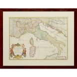
Sanson, NicolasCarte Generale de L'Italie. Paris, 1658, 57 x 41.5cm, hand-coloured engraved map,
Sanson, NicolasCarte Generale de L'Italie. Paris, 1658, 57 x 41.5cm, hand-coloured engraved map, framed and glazed ...[more]
![Saxton, Christopher - LancashireLancastriae. [London,] 1579, 50 x 41cm, hand-coloured engraved](https://portal-images.azureedge.net/auctions-2018/srly10173/images/74586044-d463-4d05-e21f-7055cb45e9c9.jpg?w=155&h=155)
Saxton, Christopher - LancashireLancastriae. [London,] 1579, 50 x 41cm, hand-coloured engraved
Saxton, Christopher - Lancashire Lancastriae. [London,] 1579, 50 x 41cm, hand-coloured engraved map, framed and glazed, not laid-down ...[more]
Scotland, 8 mapsMcKenzie, Murdoch The North-West Coast of Scotland, 1776, 110 x 98cm, bound into
Scotland, 8 mapsMcKenzie, Murdoch The North-West Coast of Scotland, 1776, 110 x 98cm, bound into covers; A Travelling Map of Scotland... hand-colo...
![[Madras, India] - [De Havilland, Thomas Fiott][Descriptions and Delineations of Some of the Public](https://portal-images.azureedge.net/auctions-2018/srly10173/images/c7029512-dadf-40fd-cee5-6232f7c72186.jpg?w=155&h=155)
[Madras, India] - [De Havilland, Thomas Fiott][Descriptions and Delineations of Some of the Public
[Madras, India] - [De Havilland, Thomas Fiott][Descriptions and Delineations of Some of the Public and Other Edifices at and in the Vicinity of Ma...
Edmondston, ArthurA View of the Ancient and Present State of the Zetland Islands. Edinburgh:
Edmondston, ArthurA View of the Ancient and Present State of the Zetland Islands. Edinburgh: Longman, Hurst, Rees, and Orme, 1809. 2 volumes, 8vo,...
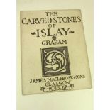
Graham, Robert CunninghameThe Carved Stones of Islay. Glasgow: James Maclehose & Sons, 1895. 4to,
Graham, Robert CunninghameThe Carved Stones of Islay. Glasgow: James Maclehose & Sons, 1895. 4to, engraved title-page, map, 32 plates, original br...
Jameson, RobertAn Outline of the Mineralogy of the Shetland Islands, and the Island of Arran.
Jameson, RobertAn Outline of the Mineralogy of the Shetland Islands, and the Island of Arran. Edinburgh: William Creech, 1798. First edition, 8vo,...
![[Knox, John]A View of the British Empire, more especially Scotland... London: J. Walter, 1784.](https://portal-images.azureedge.net/auctions-2018/srly10173/images/6ebdf474-e68f-43ce-d093-175cff5e6930.jpg?w=155&h=155)
[Knox, John]A View of the British Empire, more especially Scotland... London: J. Walter, 1784.
[Knox, John]A View of the British Empire, more especially Scotland... London: J. Walter, 1784. 8vo [ESTC T50762]; [bound with] [Idem] A Tour throu...
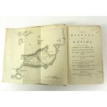
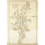
MacAulay, KennethThe History of St Kilda. London: T. Becket and P.A. De Hondt, 1764. 8vo, folding
MacAulay, KennethThe History of St Kilda. London: T. Becket and P.A. De Hondt, 1764. 8vo, folding map, lacking half-title, contemporary calf, earl...
![Moray - [Leslie, William]An Account of the Antiquities, Modern Buildings and Natural Curiosities](https://portal-images.azureedge.net/auctions-2018/srly10173/images/0e1e4a3d-8b11-42df-e0d2-3f8c609c763a.jpg?w=155&h=155)
Moray - [Leslie, William]An Account of the Antiquities, Modern Buildings and Natural Curiosities
Moray - [Leslie, William]An Account of the Antiquities, Modern Buildings and Natural Curiosities in the Province of Moray. Edinburgh: J. Forsyth, ...
![[Shaw, Stebbing]A Tour in 1787, from London to the Western Highlands of Scotland. Including](https://portal-images.azureedge.net/auctions-2018/srly10173/images/1696fa00-768b-4756-df7c-68dff730d1d4.jpg?w=155&h=155)
[Shaw, Stebbing]A Tour in 1787, from London to the Western Highlands of Scotland. Including Excursions to the Lakes of Westmorland and Cumberland....