Filtered by:
- Category
- List
- Grid
A subscription to the Price Guide is required to view results for auctions ten days or older. Click here for more information

MAP - JOHN NORDEN 'The Description of Penwithe Hundred' hand coloured engraved map, 17 x 32cm.
MAP - JOHN NORDEN 'The Description of Penwithe Hundred' hand coloured engraved map, 17 x 32cm.
MAP - JOHN NORDEN 'The description of Stratton Hundred', hand coloured engraved map, 23 x 32cm.
MAP - JOHN NORDEN 'The description of Stratton Hundred', hand coloured engraved map, 23 x 32cm.
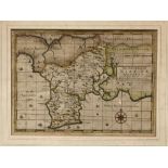
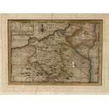
MAP - JOHN NORDEN - 'The Description of Powder Hundred', hand coloured engraved map, 23 x 32cm.
MAP - JOHN NORDEN - 'The Description of Powder Hundred', hand coloured engraved map, 23 x 32cm.
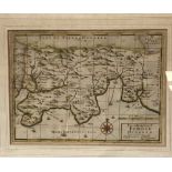
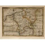
MAP - JOHN NORDEN - 'The Description of Kirrier Hundred', hand coloured engraved map, 23 x 32.5cm.
MAP - JOHN NORDEN - 'The Description of Kirrier Hundred', hand coloured engraved map, 23 x 32.5cm.
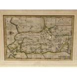
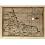
MAP - JOHN NORDEN - 'The Description Of East Hundred', hand coloured engraved map, 22 x 34.5cm.
MAP - JOHN NORDEN - 'The Description Of East Hundred', hand coloured engraved map, 22 x 34.5cm.
MAP - JOHN NORDEN - 'The Description Of Lesnewth Hundred', hand coloured engraved map, 23 x 33.5cm.
MAP - JOHN NORDEN - 'The Description Of Lesnewth Hundred', hand coloured engraved map, 23 x 33.5cm.
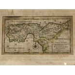
MAP - JOHN NORDEN - 'The Description Of Pyder Hundred', hand coloured engraved map, 22.5 x 33.5cm.
MAP - JOHN NORDEN - 'The Description Of Pyder Hundred', hand coloured engraved map, 22.5 x 33.5cm.
MAP - JOHN NORDEN - 'The Description Of Trig Hundred', hand coloured engraved map, 23.5 x 33.5cm.
MAP - JOHN NORDEN - 'The Description Of Trig Hundred', hand coloured engraved map, 23.5 x 33.5cm.
MAP - JOHN NORDEN - 'The Description Of West Hundred', hand coloured engraved map, 23 x 32.5cm.
MAP - JOHN NORDEN - 'The Description Of West Hundred', hand coloured engraved map, 23 x 32.5cm.
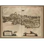
MAP - Scottish Islands after Blaeu (J.& Pont T.) - 'Leogvs et Haraia Insulaex Aebudarum Numero...
MAP - Scottish Islands after Blaeu (J.& Pont T.) - 'Leogvs et Haraia Insulaex Aebudarum Numero...LEWIS AND HARRAY', unframed, hand coloured copper...
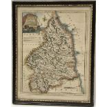
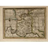
MAP - Published by Robert Sayer and engraved by J. Ellis 'A Modern Map of Northumberland, drawn from
MAP - Published by Robert Sayer and engraved by J. Ellis 'A Modern Map of Northumberland, drawn from the latest survey's ....', 25 x 20cm.
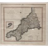
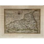
MAP - 'A New Map of The County of Cornwall Divided Into Hundreds', printed for C. Smith No.172
MAP - 'A New Map of The County of Cornwall Divided Into Hundreds', printed for C. Smith No.172 Strand, January 1804, hand coloured copper engraved...
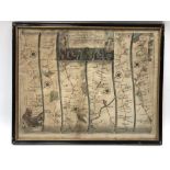
MAP - John Ogilby 'The Road From London To Hith In Com Kent ....', hand coloured copper engraved
MAP - John Ogilby 'The Road From London To Hith In Com Kent ....', hand coloured copper engraved map, 33 x 42cm.
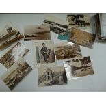
A quantity of loose postcards, mostly of topographical interest, including Cornwall and Isles of
A quantity of loose postcards, mostly of topographical interest, including Cornwall and Isles of Scilly.
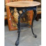
A cast iron framed pub table, cast with figures of Britannia with mahogany top.