
Filtered by:
- Category
- List
- Grid
This auctioneer has chosen to not publish their results. Please contact them directly for any enquiries.
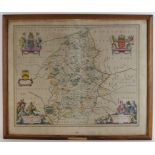

Blaeu (Johannes), Staffordiensis comitatus vulgo Stafford Shire (Staffordshire), published Amsterdam, circa 1648, hand-coloured engraved map, fram...
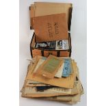
Ephemera. A collection of sheet music, ordinance survey maps etc. (sold as seen)
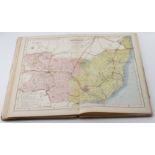
Letts (publisher). Letts's popular county atlas, being a complete series of maps delineating the
Letts (publisher). Letts's popular county atlas, being a complete series of maps delineating the whole surface of England and Wales..., 1884, fort...
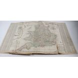
Moll (Hermann 1654-1732). A collection of fifteen folding engraved maps (hand coloured in outline)
Moll (Hermann 1654-1732). A collection of fifteen folding engraved maps (hand coloured in outline) bound in contemporary boards, from the atlas 'T...
Smith (Charles). Smiths New General Atlas, containing distinct maps of all the principal Empires,
Smith (Charles). Smiths New General Atlas, containing distinct maps of all the principal Empires, Kingdoms & States throughout the World, 1809, en...
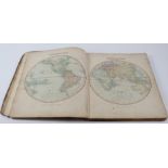
Turner (Rev. R.). A new and easy introduction to universal geography in a series of letters to a
Turner (Rev. R.). A new and easy introduction to universal geography in a series of letters to a youth at school, 5th edition, 1792, folding engra...
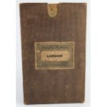
Wyld (James). Wylds Plan of the City of London, 1842, folding engraved map, contained in original
Wyld (James). Wylds Plan of the City of London, 1842, folding engraved map, contained in original case, total size 66.5cm x 134cm approx.
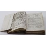
[Swift Jonathan]. Travels into several remote nations of the World, by Captain Lemuel Gulliver,
[Swift Jonathan]. Travels into several remote nations of the World, by Captain Lemuel Gulliver, volume 2 only, printed for Benjamin Motte, 1727, n...