Filtered by:
- Category
- List
- Grid
A subscription to the Price Guide is required to view results for auctions ten days or older. Click here for more information
![[AMERICANA / CONFEDERATE] a collection of Confederate era photos / portraits, including: a fine](https://portal-images.azureedge.net/auctions-2021/srjo10315/images/68d9519e-b288-42e9-b75d-ad7500ef45fa.jpg?w=155&h=155)

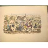
[AMERICANA / CONFEDERATE] a collection of Confederate era photos / portraits, including: a fine
[AMERICANA / CONFEDERATE] a collection of Confederate era photos / portraits, including: a fine group photo of Colonel John S. MOSBY & some of his...
![[ROYALTY] a fine 17th c. engraving, early colouring, of the Arms of Charles II, f & g, 42 x 28 cms.](https://portal-images.azureedge.net/auctions-2021/srjo10315/images/8cdd6d99-8bf4-4993-9431-ad7500ef4da9.jpg?w=155&h=155)
[ROYALTY] a fine 17th c. engraving, early colouring, of the Arms of Charles II, f & g, 42 x 28 cms.
[ROYALTY] a fine 17th c. engraving, early colouring, of the Arms of Charles II, f & g, 42 x 28 cms. ...[more]
![[JAMAICA] a fine series of 5 small theatre bils, 3 printed on silk (of which 1 is split in 3) and](https://portal-images.azureedge.net/auctions-2021/srjo10315/images/76062062-31e9-4be1-9992-ad7500ef4f63.jpg?w=155&h=155)
[JAMAICA] a fine series of 5 small theatre bils, 3 printed on silk (of which 1 is split in 3) and
[JAMAICA] a fine series of 5 small theatre bils, 3 printed on silk (of which 1 is split in 3) and 2 on paper, for amateur productions at The Theat...
![[ANTIQUITY] loose collection of plates, ca. 100, some hand-col'd, from "Antiquites . . . du](https://portal-images.azureedge.net/auctions-2021/srjo10315/images/e2d3df23-7ea4-46af-aff1-ad7c01031c3a.jpg?w=155&h=155)
[ANTIQUITY] loose collection of plates, ca. 100, some hand-col'd, from "Antiquites . . . du Cabinet de M. Hamilton," [i.e. Sir William Hamilton's ...
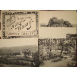
BOVEY TRACEY, set of 6 views, "Folio Series," with original envelope
MAGNA CARTA. PINE (John) engraver / publisher, engraving with hand-col'd armorials border, trimmed
MAGNA CARTA. PINE (John) engraver / publisher, engraving with hand-col'd armorials border, trimmed to platemark and laid on canvas, (chipping, a h...
![[PRINT FESTIVAL POSTER] CHIEZE (Jean) printer: "Saint Jean Porte Latine," col. Woodcut, 39 x 30](https://portal-images.azureedge.net/auctions-2021/srjo10315/images/5ac3b381-cedb-4f9f-800f-ad7500ef7370.jpg?w=155&h=155)
[PRINT FESTIVAL POSTER] CHIEZE (Jean) printer: "Saint Jean Porte Latine," col. Woodcut, 39 x 30
[PRINT FESTIVAL POSTER] CHIEZE (Jean) printer: "Saint Jean Porte Latine," col. Woodcut, 39 x 30 cms [S], u/f
![[MAP - ISLE of WIGHT] MORTIMER (William) surveyor: "Plan of Ryall Common in the Parish of Brading in](https://portal-images.azureedge.net/auctions-2021/srjo10315/images/954d551a-c631-451b-a7db-ad7500ef7542.jpg?w=155&h=155)
[MAP - ISLE of WIGHT] MORTIMER (William) surveyor: "Plan of Ryall Common in the Parish of Brading in
[MAP - ISLE of WIGHT] MORTIMER (William) surveyor: "Plan of Ryall Common in the Parish of Brading in the Isle of Wight . . . 1835," ink and waterc...
![[MAPS] a rolled and varnished C. & I. Greenwood map of WILTSHIRE; a hand-col'd Land Utilisation](https://portal-images.azureedge.net/auctions-2021/srjo10315/images/be736a92-7b4e-4c6e-9ed5-ad7500ef7601.jpg?w=155&h=155)
[MAPS] a rolled and varnished C. & I. Greenwood map of WILTSHIRE; a hand-col'd Land Utilisation
[MAPS] a rolled and varnished C. & I. Greenwood map of WILTSHIRE; a hand-col'd Land Utilisation Survey 1931-2 of the ISLE of WIGHT; the 1933 repro...
![[MAPS - ISLE of WIGHT] 1878 (1886) zincographed map of SANDOWN, hand-col'd, green areas = estate](https://portal-images.azureedge.net/auctions-2021/srjo10315/images/ffe259f2-b345-431b-a02e-ad7500ef7774.jpg?w=155&h=155)
[MAPS - ISLE of WIGHT] 1878 (1886) zincographed map of SANDOWN, hand-col'd, green areas = estate
[MAPS - ISLE of WIGHT] 1878 (1886) zincographed map of SANDOWN, hand-col'd, green areas = estate of J.H.Oglander, pink = W.E.D.Carter, linen-backe...
![[MAP - SUSSEX] Martin, Hood, & Larkin, lithographers: "Outlying Portions of the WEST DEAN ESTATE,](https://portal-images.azureedge.net/auctions-2021/srjo10315/images/7c5db519-ed32-48a7-96fd-ad7500ef78e7.jpg?w=155&h=155)
[MAP - SUSSEX] Martin, Hood, & Larkin, lithographers: "Outlying Portions of the WEST DEAN ESTATE,
[MAP - SUSSEX] Martin, Hood, & Larkin, lithographers: "Outlying Portions of the WEST DEAN ESTATE, Sussex. Plan of the Elsted & Treyford Portion. F...
![[MAPS - HAMPSHIRE] a series of large-scale maps relating to the estates of John BONHAM-CARTER, M.](https://portal-images.azureedge.net/auctions-2021/srjo10315/images/9eb746a8-3f8f-4da5-b709-ad7500ef7998.jpg?w=155&h=155)
[MAPS - HAMPSHIRE] a series of large-scale maps relating to the estates of John BONHAM-CARTER, M.
[MAPS - HAMPSHIRE] a series of large-scale maps relating to the estates of John BONHAM-CARTER, M.P. a) "Liss Enclosure . . . No. IV," ink & waterc...
![[EARLY 19th c. GAME] "Mappen Schlosser. Castle with the Escutcheons of their owners," [title from](https://portal-images.azureedge.net/auctions-2021/srjo10315/images/ca3705f4-ae10-42c8-9f32-ad7500f09c23.jpg?w=155&h=155)
[EARLY 19th c. GAME] "Mappen Schlosser. Castle with the Escutcheons of their owners," [title from
[EARLY 19th c. GAME] "Mappen Schlosser. Castle with the Escutcheons of their owners," [title from lid], original box with sliding lid and pasted d...
![[MAPS] 4 maps relating to Australia/NZ (3 are SDUK, of which 2 hand-col'd, 35 x 41 cms, some](https://portal-images.azureedge.net/auctions-2021/srjo10315/images/f7212741-ac35-4059-baca-ad7500ef9c0c.jpg?w=155&h=155)
[MAPS] 4 maps relating to Australia/NZ (3 are SDUK, of which 2 hand-col'd, 35 x 41 cms, some
[MAPS] 4 maps relating to Australia/NZ (3 are SDUK, of which 2 hand-col'd, 35 x 41 cms, some chipping to margins) and 6 maps & images of Asia and ...
![[MAPS] 7 maps relating to AFRICA (Bowen, hand-col'd, 38 x 41 cms [S]; Lotter; Blaeu's Ethiopia etc.)](https://portal-images.azureedge.net/auctions-2021/srjo10315/images/2d01e89d-9450-440e-b743-ad7500ef9cc3.jpg?w=155&h=155)
[MAPS] 7 maps relating to AFRICA (Bowen, hand-col'd, 38 x 41 cms [S]; Lotter; Blaeu's Ethiopia etc.)
[MAPS] 7 maps relating to AFRICA (Bowen, hand-col'd, 38 x 41 cms [S]; Lotter; Blaeu's Ethiopia etc.) (7)
![[MAPS] 3 INDIA related maps (3)](https://portal-images.azureedge.net/auctions-2021/srjo10315/images/d71ba959-9caf-4998-8728-ad7500ef9ddd.jpg?w=155&h=155)
[MAPS] 3 INDIA related maps (3)
[MAPS] 3 INDIA related maps (3)
![[MAPS] 2 x folding hand-col'd maps on linen, disbound from Southesk's "Saskatchawan and the Rocky](https://portal-images.azureedge.net/auctions-2021/srjo10315/images/16ef75e3-cb59-40e8-acd5-ad7500ef9e8a.jpg?w=155&h=155)
[MAPS] 2 x folding hand-col'd maps on linen, disbound from Southesk's "Saskatchawan and the Rocky
[MAPS] 2 x folding hand-col'd maps on linen, disbound from Southesk's "Saskatchawan and the Rocky Mountains," 1875 (2)
![[MAPS] 15 maps relating to EGYPT & ASIA (15)](https://portal-images.azureedge.net/auctions-2021/srjo10315/images/966cc70e-2974-46a8-abe3-ad7500ef9f5a.jpg?w=155&h=155)
[MAPS] 15 maps relating to EGYPT & ASIA (15) ...[more]
![[MAPS] 6 maps, charts & a view relating to SOUTH AFRICA (6)](https://portal-images.azureedge.net/auctions-2021/srjo10315/images/a4827cc5-54da-4679-8a55-ad7500efa027.jpg?w=155&h=155)
[MAPS] 6 maps, charts & a view relating to SOUTH AFRICA (6) ...[more]
![[MAPS] 5 maps & views of CONSTANTINOPLE (5)](https://portal-images.azureedge.net/auctions-2021/srjo10315/images/6c83ec0a-4a3d-4d0b-a261-ad7500efa0fe.jpg?w=155&h=155)
[MAPS] 5 maps & views of CONSTANTINOPLE (5) ...[more]
![[ASTRONOMY] 9 small hand-col'd plates by Thomas, and 2 others including a Moon Chart (11)](https://portal-images.azureedge.net/auctions-2021/srjo10315/images/a6b9315c-34e7-4663-bc4a-ad7500efa1ae.jpg?w=155&h=155)
[ASTRONOMY] 9 small hand-col'd plates by Thomas, and 2 others including a Moon Chart (11)
![[MAPS] 4 maps relating to GREECE & MACEDONIA (4)](https://portal-images.azureedge.net/auctions-2021/srjo10315/images/dc3d50e4-02ba-4f04-a2ad-ad7500efa322.jpg?w=155&h=155)
[MAPS] 4 maps relating to GREECE & MACEDONIA (4) ...[more]
![[MAPS] 6 Stanford colour maps relating to ASIA (6)](https://portal-images.azureedge.net/auctions-2021/srjo10315/images/3b2c80a9-978a-42bd-9243-ad7500efa3e9.jpg?w=155&h=155)
[MAPS] 6 Stanford colour maps relating to ASIA (6)
![[MAPS] 6 b/w charts relating to VOYAGES (6)](https://portal-images.azureedge.net/auctions-2021/srjo10315/images/e3bbd647-9fe9-4466-94a1-ad7500efa4c4.jpg?w=155&h=155)
[MAPS] 6 b/w charts relating to VOYAGES (6)
![[MAPS] 10 b/w charts and maps relating to SCANDINAVIA (10)](https://portal-images.azureedge.net/auctions-2021/srjo10315/images/5cb834e5-35e4-4608-a10e-ad7500efa57f.jpg?w=155&h=155)
[MAPS] 10 b/w charts and maps relating to SCANDINAVIA (10)
![[MAPS] 3 Scandinavian maps: Copenhagen, 1659; Valck's Denmark; Janssonius, Selandiae, small hole. (](https://portal-images.azureedge.net/auctions-2021/srjo10315/images/c23ac0de-dad2-4f92-b439-ad7500efa64b.jpg?w=155&h=155)
[MAPS] 3 Scandinavian maps: Copenhagen, 1659; Valck's Denmark; Janssonius, Selandiae, small hole. (
[MAPS] 3 Scandinavian maps: Copenhagen, 1659; Valck's Denmark; Janssonius, Selandiae, small hole. (3)
![[MAPS] 19 mixed maps, plans, etc. of EUROPE, incl. an allegorical title-page with map of Greece,](https://portal-images.azureedge.net/auctions-2021/srjo10315/images/7b3bf375-98e6-4d28-b989-ad7500efa769.jpg?w=155&h=155)
[MAPS] 19 mixed maps, plans, etc. of EUROPE, incl. an allegorical title-page with map of Greece,
[MAPS] 19 mixed maps, plans, etc. of EUROPE, incl. an allegorical title-page with map of Greece, dated 1716 (19)
![[MAPS] 25 assorted maps & plans of Europe -Germany, Holland, etc. (25)](https://portal-images.azureedge.net/auctions-2021/srjo10315/images/d55c993e-5b3f-4e84-b8b4-ad7500efa868.jpg?w=155&h=155)
[MAPS] 25 assorted maps & plans of Europe -Germany, Holland, etc. (25) ...[more]
![[MAPS] 14 assorted maps of the British Isles, some a/f (14)](https://portal-images.azureedge.net/auctions-2021/srjo10315/images/dd6d5afd-c04d-409e-9525-ad7500efa95f.jpg?w=155&h=155)
[MAPS] 14 assorted maps of the British Isles, some a/f (14)
![[MAPS] 14 assorted maps relating to the AMERICAS (14)](https://portal-images.azureedge.net/auctions-2021/srjo10315/images/5b579ba6-0497-4fdb-93ea-ad7500efaa6e.jpg?w=155&h=155)
[MAPS] 14 assorted maps relating to the AMERICAS (14)
![[MAPS] 12 maps relating to ASIA, Zatta et alia (12)](https://portal-images.azureedge.net/auctions-2021/srjo10315/images/071b3552-be42-4556-8e22-ad7500efac01.jpg?w=155&h=155)
[MAPS] 12 maps relating to ASIA, Zatta et alia (12)
![[MAPS - UK] 11 North Country maps, etc., including Pigot's Monmouthshire, Denbigh, Rutland, Chester,](https://portal-images.azureedge.net/auctions-2021/srjo10315/images/29086862-b5f0-46c6-88ec-ad7500efae0c.jpg?w=155&h=155)
[MAPS - UK] 11 North Country maps, etc., including Pigot's Monmouthshire, Denbigh, Rutland, Chester,
[MAPS - UK] 11 North Country maps, etc., including Pigot's Monmouthshire, Denbigh, Rutland, Chester, etc. (11)
![[MAPS - UK] 13 Southern County maps, incl. Essex, Middlesex, Surrey, Dorset, etc. (13)](https://portal-images.azureedge.net/auctions-2021/srjo10315/images/8e2bb22d-9505-4b02-b8bc-ad7500efaeef.jpg?w=155&h=155)
[MAPS - UK] 13 Southern County maps, incl. Essex, Middlesex, Surrey, Dorset, etc. (13)
![[MAPS] 17 maps of parts of FRANCE, some by Sanson & laid on linen, some with library stamps (17)](https://portal-images.azureedge.net/auctions-2021/srjo10315/images/aae43a29-2a58-43d7-b821-ad7500efaff1.jpg?w=155&h=155)
[MAPS] 17 maps of parts of FRANCE, some by Sanson & laid on linen, some with library stamps (17)
[MAPS] 17 maps of parts of FRANCE, some by Sanson & laid on linen, some with library stamps (17) ...[more]
![[ITALY] Chart of the approaches to Genova and 11 other maps and views relating to Italy to](https://portal-images.azureedge.net/auctions-2021/srjo10315/images/b4520544-2d97-48f8-8f0a-ad7500efb365.jpg?w=155&h=155)
[ITALY] Chart of the approaches to Genova and 11 other maps and views relating to Italy to include: De L'Isle Italy, New Map of Latium Etruria......
![[FRANCE] 11 maps & views relating to France to include: Carte des Pais Bas; Le Rouge, Tableau](https://portal-images.azureedge.net/auctions-2021/srjo10315/images/e9a09ac0-cee5-4739-bb17-ad7500efb42c.jpg?w=155&h=155)
[FRANCE] 11 maps & views relating to France to include: Carte des Pais Bas; Le Rouge, Tableau
[FRANCE] 11 maps & views relating to France to include: Carte des Pais Bas; Le Rouge, Tableau Topographique des Environs de Paris; Carte de France...
![[MAPS] 15 folding National Geographic maps (world, America, etc.) & 2 AERIAL VIEWS (17)](https://portal-images.azureedge.net/auctions-2021/srjo10315/images/ba6ec40f-cac6-46c7-88a5-ad7500efb5e7.jpg?w=155&h=155)
[MAPS] 15 folding National Geographic maps (world, America, etc.) & 2 AERIAL VIEWS (17) ...[more]
![[MAPS] 4 folding maps: Wigram's Holy-Land; Philip-Stanford Palestine; Bombay - on linen; and](https://portal-images.azureedge.net/auctions-2021/srjo10315/images/6a6c01a5-9555-4872-9967-ad7500efb6a7.jpg?w=155&h=155)
[MAPS] 4 folding maps: Wigram's Holy-Land; Philip-Stanford Palestine; Bombay - on linen; and
[MAPS] 4 folding maps: Wigram's Holy-Land; Philip-Stanford Palestine; Bombay - on linen; and Philip's Authentic Imperial Maps - India (4)
![[MAPS, etc.] Carte de L'Empire de Maroc, Paris 1848; Delkeskamp: Atlas Pittoresque du Rhin, 1844;](https://portal-images.azureedge.net/auctions-2021/srjo10315/images/7d756524-71b0-4c46-9e37-ad7500efb78a.jpg?w=155&h=155)
[MAPS, etc.] Carte de L'Empire de Maroc, Paris 1848; Delkeskamp: Atlas Pittoresque du Rhin, 1844;
[MAPS, etc.] Carte de L'Empire de Maroc, Paris 1848; Delkeskamp: Atlas Pittoresque du Rhin, 1844; double-sided silk/cotton folding map showing Gre...
![[MAPS] 6 folding maps: LT Bus Map; LT Trolleybus & Tram Map; LU Tramways Guide; Bacon's Cycling Road](https://portal-images.azureedge.net/auctions-2021/srjo10315/images/b5022d6b-4a1a-4db1-bb9c-ad7500efb933.jpg?w=155&h=155)
[MAPS] 6 folding maps: LT Bus Map; LT Trolleybus & Tram Map; LU Tramways Guide; Bacon's Cycling Road
[MAPS] 6 folding maps: LT Bus Map; LT Trolleybus & Tram Map; LU Tramways Guide; Bacon's Cycling Road Map of England; Map and Guide L.C.C. Trams an...
![[LONDON / THAMES] W.H. Smith's Plan of London; and The Oarsman's and Angler's Map of the River](https://portal-images.azureedge.net/auctions-2021/srjo10315/images/77f8a6ca-2026-43d4-a824-ad7500efba40.jpg?w=155&h=155)
[LONDON / THAMES] W.H. Smith's Plan of London; and The Oarsman's and Angler's Map of the River
[LONDON / THAMES] W.H. Smith's Plan of London; and The Oarsman's and Angler's Map of the River Thames, new edition, 1919 (2)
![[THAMES] Coloured Chart of the Thames Estuary, section 3 only, folding into covers, label; Birds Eye](https://portal-images.azureedge.net/auctions-2021/srjo10315/images/087763ef-742d-493f-bfca-ad7500efbc05.jpg?w=155&h=155)
[THAMES] Coloured Chart of the Thames Estuary, section 3 only, folding into covers, label; Birds Eye
[THAMES] Coloured Chart of the Thames Estuary, section 3 only, folding into covers, label; Birds Eye View of the River Thames from Oxford to Londo...
![[LONDON / THAMES] Cruchley's Handy Map of London; and The Oarsman's and Angler's Map of the River](https://portal-images.azureedge.net/auctions-2021/srjo10315/images/5cd1da07-3584-4063-9327-ad7500efbcf3.jpg?w=155&h=155)
[LONDON / THAMES] Cruchley's Handy Map of London; and The Oarsman's and Angler's Map of the River
[LONDON / THAMES] Cruchley's Handy Map of London; and The Oarsman's and Angler's Map of the River Thames. New Edition (2)
![[MAP] James Wyld's Folding Plan of London (1)](https://portal-images.azureedge.net/auctions-2021/srjo10315/images/41582dab-2b60-4444-8be9-ad7500efbe1c.jpg?w=155&h=155)
[MAP] James Wyld's Folding Plan of London (1)
![[MAPS] Stanford's New Map of the Parliamentary Divisions & Boroughs of England and Wales; and,](https://portal-images.azureedge.net/auctions-2021/srjo10315/images/28d81e58-f903-42b1-8802-ad7500efbef3.jpg?w=155&h=155)
[MAPS] Stanford's New Map of the Parliamentary Divisions & Boroughs of England and Wales; and,
[MAPS] Stanford's New Map of the Parliamentary Divisions & Boroughs of England and Wales; and, Gross, Alexander - General Reference Map of England...
![[MAPS] 4 folding Ordnance Survey Maps Kent and London SE & SW. (4)](https://portal-images.azureedge.net/auctions-2021/srjo10315/images/3103d992-ff23-472b-a990-ad7500efbfa9.jpg?w=155&h=155)
[MAPS] 4 folding Ordnance Survey Maps Kent and London SE & SW. (4) ...[more]
![[MAPS] 3 (of 4) folding large maps of the British Isles (North, West, South), in green morocco](https://portal-images.azureedge.net/auctions-2021/srjo10315/images/98578329-ef3b-4f80-9e45-ad7500efc09f.jpg?w=155&h=155)
[MAPS] 3 (of 4) folding large maps of the British Isles (North, West, South), in green morocco
[MAPS] 3 (of 4) folding large maps of the British Isles (North, West, South), in green morocco covers, all hand-coloured. (3)
![[MAP] Richardson's New Chart of the British Isles, large folding col. Map (1)](https://portal-images.azureedge.net/auctions-2021/srjo10315/images/086da4ac-5589-4c6a-b30c-ad7500efc15d.jpg?w=155&h=155)
[MAP] Richardson's New Chart of the British Isles, large folding col. Map (1)
![[MAP] KARS (J.P.) large (82 x 103 cms) wall map of Greece, wooden rollers](https://portal-images.azureedge.net/auctions-2021/srjo10315/images/76ffeee5-8035-46f5-b058-ad7500efc309.jpg?w=155&h=155)
[MAP] KARS (J.P.) large (82 x 103 cms) wall map of Greece, wooden rollers
![[MAP] Bacon's New Chart of the World, 95 x 122 cms, laminated, rollers (one off)](https://portal-images.azureedge.net/auctions-2021/srjo10315/images/ab3988f5-e0ea-484a-885a-ad7500efc3e9.jpg?w=155&h=155)
[MAP] Bacon's New Chart of the World, 95 x 122 cms, laminated, rollers (one off)
![[MAPS] 7 Black and white maps: S. America, Spain & Portugal, Europe, Scandinavia, Africa and](https://portal-images.azureedge.net/auctions-2021/srjo10315/images/dc98119a-b40b-44a9-9c72-ad7500efc6bf.jpg?w=155&h=155)
[MAPS] 7 Black and white maps: S. America, Spain & Portugal, Europe, Scandinavia, Africa and
[MAPS] 7 Black and white maps: S. America, Spain & Portugal, Europe, Scandinavia, Africa and Scotland x 2 (7) ...[more]
![[MAPS etc.] 6 French collectible cards (each 110 x 70 mm) depicting Australian views and customs,](https://portal-images.azureedge.net/auctions-2021/srjo10315/images/b752af32-b350-4986-99b1-ad7500efc8ad.jpg?w=155&h=155)
[MAPS etc.] 6 French collectible cards (each 110 x 70 mm) depicting Australian views and customs,
[MAPS etc.] 6 French collectible cards (each 110 x 70 mm) depicting Australian views and customs, c.1900; 19 French collectible country cards (eac...
![[MAP] G. F. Cruchley's large, folding wall map of Europe, on four sheets, in slip case (tight)](https://portal-images.azureedge.net/auctions-2021/srjo10315/images/54f9ec79-9ddd-4b7e-aa23-ad7500efc983.jpg?w=155&h=155)
[MAP] G. F. Cruchley's large, folding wall map of Europe, on four sheets, in slip case (tight)
[MAP] G. F. Cruchley's large, folding wall map of Europe, on four sheets, in slip case (tight)
![[MAPS] 2 maps of South America: W. Faden's 'Mapa Geografico de America Meridional', 1799, a very](https://portal-images.azureedge.net/auctions-2021/srjo10315/images/19c043f9-ce30-41df-bf1a-ad7500efca69.jpg?w=155&h=155)
[MAPS] 2 maps of South America: W. Faden's 'Mapa Geografico de America Meridional', 1799, a very
[MAPS] 2 maps of South America: W. Faden's 'Mapa Geografico de America Meridional', 1799, a very large folding map of South America (staining, a/f...
![[MAP - CANADA] Stanford's folding map of Canada / British North America, in slip case, 110 x 130](https://portal-images.azureedge.net/auctions-2021/srjo10315/images/f642b104-0bd9-4591-90f8-ad7500efcc39.jpg?w=155&h=155)
[MAP - CANADA] Stanford's folding map of Canada / British North America, in slip case, 110 x 130
[MAP - CANADA] Stanford's folding map of Canada / British North America, in slip case, 110 x 130 cms, extensive splitting to linen backing.
![[MAP] 'Betts's Tour Through Europe', folding map of Europe, missing board cover](https://portal-images.azureedge.net/auctions-2021/srjo10315/images/c2a97987-c167-4d64-8768-ad7500efccfd.jpg?w=155&h=155)
[MAP] 'Betts's Tour Through Europe', folding map of Europe, missing board cover
![[MAP - AMERICA] large linen-backed folding Railway Map of the United States, copyrighted 1902-](https://portal-images.azureedge.net/auctions-2021/srjo10315/images/39bc5b1e-a32d-4fad-9d6f-ad7500efcdf3.jpg?w=155&h=155)
[MAP - AMERICA] large linen-backed folding Railway Map of the United States, copyrighted 1902-
[MAP - AMERICA] large linen-backed folding Railway Map of the United States, copyrighted 1902-1918, 110 x 130 cms
W Faden's folding Map of Suffolk, 1787, slipcase; Bennet's Map & Guide to the Thames; C.W.S.
W Faden's folding Map of Suffolk, 1787, slipcase; Bennet's Map & Guide to the Thames; C.W.S. descriptive booklet (140 x 210 mm, 32pp) featuring ma...
H.M.S.O. Fisheries Reports, multiple titles in 4 vols folio, not a run, maps, library cloth, L.,
H.M.S.O. Fisheries Reports, multiple titles in 4 vols folio, not a run, maps, library cloth, L., 1905, 1911, 1913, 1914 (4)
LEECH (John) Follies of the Year, obl. 4to, 21 hand-col'd plates, half morocco, L., n.d.