Filtered by:
- Category
4 items
- List
- Grid
This auctioneer has chosen to not publish their results. Please contact them directly for any enquiries.

Lot 78
Maps: To include Ordnance Survey of England South price three shillings, Ordnance Survey one inch
Maps: To include Ordnance Survey of England South price three shillings, Ordnance Survey one inch map fifth edition Salisbury and Winchester, Town...
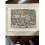
Maps: 17th/18th cent. Hand coloured engraved map of Tunis laid on board. 12½ins. x 16¼ins.
Lot 87
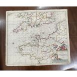
Maps: Canalis inter Anglia et Gallia Tabula, map of the English Channel and adjoining areas of
Maps: Canalis inter Anglia et Gallia Tabula, map of the English Channel and adjoining areas of France and Great Britain. Crease to centre. 19ins. ...
Lot 292
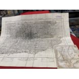
Maps: Military edition England, South East and London fourth edition sheet 12. 30ins. x 39½ins. Plus
Maps: Military edition England, South East and London fourth edition sheet 12. 30ins. x 39½ins. Plus a plan of Weymouth engraved by B. Baker.