Refine your search
Filtered by:
- Category
- List
- Grid
A subscription to the Price Guide is required to view results for auctions ten days or older. Click here for more information
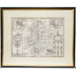

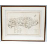
Speed, John (1552-1629). 17th-century map of Warwickshire, uncoloured copper engraving on laid/
Speed, John (1552-1629). 17th-century map of Warwickshire, uncoloured copper engraving on laid/chain-lined paper, featuring inset views of Coventr...
A George III textile map sampler, showing the counties of England and Wales, worked in coloured
A George III textile map sampler, showing the counties of England and Wales, worked in coloured silks on linen by Elizabeth Freeth and dated 1784,...
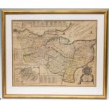
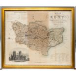
Saxton & Kip. 17th-century map of Kent, hand-coloured engraving on laid/chain-lined paper, framed & glazed, 29.5cm by 39.5cm ...[more]
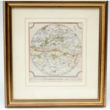
Lea, Philip. Map of Kent, c.1693, copper engraving on laid/chain-lined paper, minimal hand-
Lea, Philip. Map of Kent, c.1693, copper engraving on laid/chain-lined paper, minimal hand-colouring, featuring decorative cartouche, inset view o...
Collection of four antique maps of Kent, comprising: Robert Morden; John Ogilby (road from London to
Collection of four antique maps of Kent, comprising: Robert Morden; John Ogilby (road from London to Hith); J. & C. Walker (sectional, linen-backe...
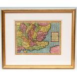
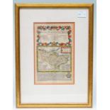
Mercator / Van den Keere. 17th-century map of South East England, copper engraving on laid/chain-
Mercator / Van den Keere. 17th-century map of South East England, copper engraving on laid/chain-lined paper, vibrant early hand-colouring. Framed...
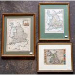
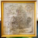
Collection of five antique maps of British Isles, Great Britain and Ireland, England. 18th- and
Collection of five antique maps of British Isles, Great Britain and Ireland, England. 18th- and 19th-century hand-coloured copper engravings, incl...
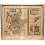
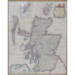
Blaeu, Joan; Robert Gordon. 17th-century map of Scotland, c.1654, hand-coloured copper engraving
Blaeu, Joan; Robert Gordon. 17th-century map of Scotland, c.1654, hand-coloured copper engraving on laid/chain-lined paper. Framed & glazed, 50cm ...
Collection of four antique maps, comprising: A Map of the Hundred of Wachlingstone (Kent), by Bayly;
Collection of four antique maps, comprising: A Map of the Hundred of Wachlingstone (Kent), by Bayly; A Map of the Lowy of Tunbridge (Kent), by Bay...
Collection of antique maps of Kent, 17th to 19th century, including Van den Keere, Jenner, Rocque,
Collection of antique maps of Kent, 17th to 19th century, including Van den Keere, Jenner, Rocque, Carington Bowles, Conder, Archer, Zuliani. Fram...
Collection of 18th- and 19th-century maps (Cambridgeshire, Essex, Middlesex, Thanet, Tunbridge
Collection of 18th- and 19th-century maps (Cambridgeshire, Essex, Middlesex, Thanet, Tunbridge Wells, Canterbury), including Owen & Bowen, Hinton,...
Collection of antique maps of Kent, 18th to 19th century, including Owen & Bowen, Toms, Leigh,
Collection of antique maps of Kent, 18th to 19th century, including Owen & Bowen, Toms, Leigh, Whittaker, Moll, Morden, Archer, Moule. Framed & gl...
Collection of framed antique maps to include Great Britain and Ireland with ye Judges Circuits, John
Collection of framed antique maps to include Great Britain and Ireland with ye Judges Circuits, John Stockdale, 1805; A Map of the Kingdom of Scot...
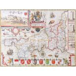
Speed, John. 17th-century map of Cornwall, hand-coloured copper engraving on laid/chain-lined paper,
Speed, John. 17th-century map of Cornwall, hand-coloured copper engraving on laid/chain-lined paper, Sudbury & Humble. Featuring inset view of Lau...
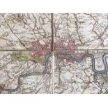
Faden, William (1749-1836). George III period map of London, 1795. Hand-coloured copper engraving on
Faden, William (1749-1836). George III period map of London, 1795. Hand-coloured copper engraving on laid/chain-lined paper; sectional; linen-back...
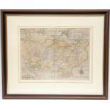
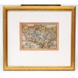
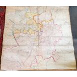
George IV map of Warwickshire, by Greenwood & Co., hand-coloured copper engraving; sectional;
George IV map of Warwickshire, by Greenwood & Co., hand-coloured copper engraving; sectional; linen-backed; engraved by J. & C. Walker, 24 Februar...
![Speed, John (1552-1629). 17th-century map of Warwickshire, first edition [1611], uncoloured copper](https://portal-images.azureedge.net/auctions-2020/hanson10249/images/2f4cfbab-ddbc-41e0-a61e-ab8700afcb99.jpg?w=155&h=155)
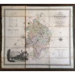
Speed, John (1552-1629). 17th-century map of Warwickshire, first edition [1611], uncoloured copper
Speed, John (1552-1629). 17th-century map of Warwickshire, first edition [1611], uncoloured copper engraving on laid/chain-lined paper bearing man...
Large Victorian map of Rocester in Staffordshire, published by Ordnance Survey, 1882, hand-coloured,
Large Victorian map of Rocester in Staffordshire, published by Ordnance Survey, 1882, hand-coloured, linen-backed, with wooden hanging supports. 2...