Filtered by:
- Category
- List
- Grid
A subscription to the Price Guide is required to view results for auctions ten days or older. Click here for more information
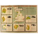

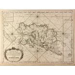
The National Parks of England and Wales, 1955 British travel/tourism colour lithographic poster,
The National Parks of England and Wales, 1955 British travel/tourism colour lithographic poster, printed for H. M. Stationery Office by R. B. Macm...
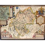
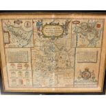
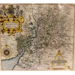
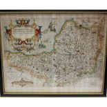
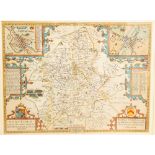
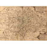
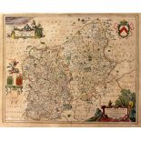
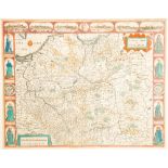
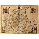
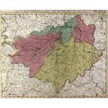
Speed, John (1552-1629).
Speed, John (1552-1629). 17th-century map of Westmorland, hand-coloured copper engraving on laid/chain-lined paper, decorative cartouches and inse...
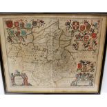
Jansson, Jan (1588-1664).
Jansson, Jan (1588-1664). 17th-century map of Cambridgeshire, hand-coloured copper-engraving on laid/chain-lined paper, decorative cartouche and a...
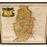
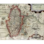
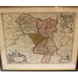
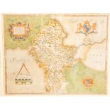
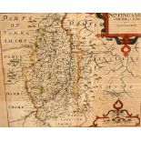
Morden, Robert (1650-1703).
Morden, Robert (1650-1703). Map of Nottinghamshire, hand-coloured copper-engraving on laid/chain-lined paper. 36.5cm x 43cm. Together with a Morde...
Collection of 60 'Mapograph' rollers together with two hand-rollers and inking tin. To include North America, USA, British Isles, Thames Basin, Wo...
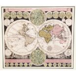
Georgian World Map. Zürner, Adam Friedrich (1679-1742). Planisphaerium Terrestre, double-hemisphere world map, Amsterdam: Schenk [c.1710]. Copper ...
Langley's New Map of Northumberland, 1818, and A Correct Map of Notts, both framed (2)
Speed, John (1552-1629).
Speed, John (1552-1629). 17th-century map of Huntington (Cambridgeshire), hand-coloured copper engraving on laid/chain-lined paper, featuring armo...
Saxton & Kip, 17th-century map of Nottingham, hand-coloured copper-engraving on laid/chain-lined paper. Together with another of Caernarfon/Wales....
Collection of five 17th/18th-century English county maps: two Saxton & Hole maps (Shropshire and
Collection of five 17th/18th-century English county maps: two Saxton & Hole maps (Shropshire and Gloucestershire); three Robert Morden maps (Warwi...
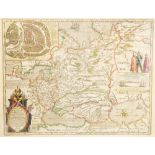
Collection of five 18th & 19th Century copper-engraved hand-coloured maps of Staffordshire (including Emanuel Bowen, Teesdale, J. Ellis) together ...
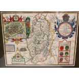
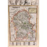
Speed, John (1552-1629).
Speed, John (1552-1629). 17th-century map of Nottinghamshire, hand-coloured copper engraving on laid/chain-lined paper, featuring heraldic shields...
17th-century map of Derbyshire, Schenk & Valk, hand-coloured copper-engraving on laid/chain-lined paper. Framed & glazed. 46.5cm x 56.5cm
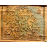
British Railways map of Yorkshire, Estra Clark, published 1949, backed with linen on wooden supports
Derbyshire Interest.
Derbyshire Interest. Collection of antique maps of Derbyshire, 17th to 19th Century, to include Christopher Saxton & Philip Lea, John Speed (Basse...
Speed, John (1552-1629).
Speed, John (1552-1629). 17th-century hand-coloured copper-engraved map of Flintshire on laid/chain-lined paper, Sudbury & Humble, English text to...
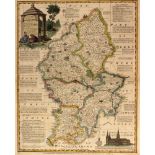
Railway Interest.
Railway Interest. Betts's New Itinerant and Commercial Map of England & Wales, with the Various Lines of Railroad, Turnpike & Principal Cross Road...
1870s map of Spain & Portugal, linen-backed, original Stanford buckram case. Together with an Edwardian map of England & Wales, colour lithographi...
Collection of 17th & 18th Century maps of Somerset, all copper-engraved on laid/chain-lined paper with hand-colouring: Saxton/Kip map of Somerset ...
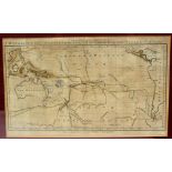
Collection of three 18th-century maps: 'New Discoveries in the South Sea with the Tracks of the
Collection of three 18th-century maps: 'New Discoveries in the South Sea with the Tracks of the Navigators' (London, Wilkie, 1785); 'Negroland and...
Saxton, Christopher (1540-1610).
Saxton, Christopher (1540-1610). 16th-century map of Staffordshire, hand-coloured copper engraving on laid/chain-lined paper. Framed & glazed. 39....
Speed, John (1552-1629).
Speed, John (1552-1629). 17th-century map of Staffordshire, hand-coloured copper engraving on laid/chain-lined paper, featuring heraldic shields a...
Christopher Saxton & Philip Lea, 17th-century map of Staffordshire, featuring inset views of Lichfield and Stafford, hand-coloured copper engravin...
Blaeu, Joan (1596-1673).
Blaeu, Joan (1596-1673). 17th-century map of Staffordshire, featuring coats-of-arms and figures displaying the fashions of the period, hand-colour...
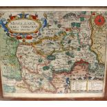
Norden, John (1547-1625).
Norden, John (1547-1625). 17th-century map of Middlesex, hand-coloured copper engraving on laid/chain-lined paper, showing London and the Thames. ...
Saxton & Kip, 17th-century map of Nottinghamshire, hand-coloured copper engraving on laid/chain-lined paper. Together with Saxton & Hole, 17th-cen...
Collection of 14 framed & glazed antique maps of Staffordshire: Charles Smith [c.1801]; Herman Moll [c.1733]; Pieter Van Den Keere "Miniature Spee...
Speed, John (1552-1629).
Speed, John (1552-1629). 17th-century map of Staffordshire, hand-coloured copper engraving on laid/chain-lined paper, featuring heraldic shields a...
Collection of 19 antique Staffordshire maps, 17th to 19th Century, housed in protective folder: Emanuel Bowen, first edition [1749]; Emanuel Bowen...
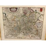
Michael Drayton map of Staffordshire, engraved by William Hole for Poly-Olbion, an unusual map with allegorical figures, copper engraving on laid/...
Jansson, Jan (1588-1664).
Jansson, Jan (1588-1664). 17th-century map of Staffordshire, hand-coloured copper engraving on laid/chain-lined paper, featuring decorative cartou...
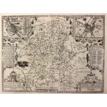
Speed, John (1552-1629).
Speed, John (1552-1629). 17th-century map of Staffordshire, copper engraving on laid/chain-lined paper, featuring inset views of Lichfield and Sta...
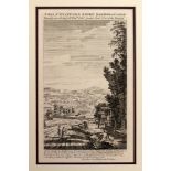
Very scarce map/prospect of Staffordshire with rural figures in foreground, George Bickham, 1754,
Very scarce map/prospect of Staffordshire with rural figures in foreground, George Bickham, 1754, engraving on laid/chain-lined paper, 'A Map of S...
![Anonymous [William Smith] 17th-century map of Staffordshire,](https://portal-images.azureedge.net/auctions-2018/hanson10152/images/cc9112ce-e70b-429c-8cec-ef1d2dc21270.jpg?w=155&h=155)
Anonymous [William Smith] 17th-century map of Staffordshire, hand-coloured copper engraving on laid/chain-lined paper, scarce, Stent & Overton, c....
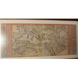
Chatelain, Henri (1684-1743). A large map of the Ottoman Empire, c.1714, hand-coloured copper engraving on laid/chain-lined paper, framed & glazed...
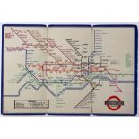
Collection of 1930s to 1950s pocket transport maps, to include London Underground No.2, 1936, and Bus Map Central Area, 1950 (7)
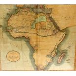
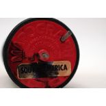
Georgian English map of Africa by John Cary, published in London in 1805, hand-coloured engraving.
Georgian English map of Africa by John Cary, published in London in 1805, hand-coloured engraving. Framed & glazed. 50cm x 60cm
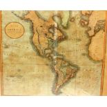
Georgian English map of America by John Cary, published in London in 1806, hand-coloured engraving,
Georgian English map of America by John Cary, published in London in 1806, hand-coloured engraving, framed. 50cm x 60cm
Speed, John (1552-1629).
Speed, John (1552-1629). 17th-century map of Poland, hand-coloured copper engraving on laid/chain-lined paper bearing manufacturer's watermark, fe...
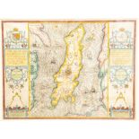
Speed, John (1552-1629).
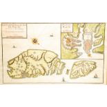
Speed, John (1552-1629). 17th-century map of the Isle of Man, hand-coloured copper engraving on laid/chain-lined paper, featuring ships and sea mo...
Speed, John (1552-1629).
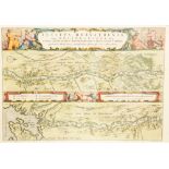
Speed, John (1552-1629). 17th-century map of the Low Countries ('Ye XVII Provinces of Low Germanie'), showing Belgium and the Netherlands, featuri...
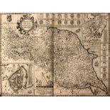
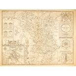
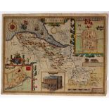
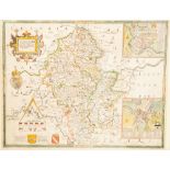
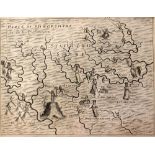
Speed, John (1552-1629).
Speed, John (1552-1629). 17th-century map of The North & East Riding of Yorkshire, copper engraving on laid/chain-lined paper bearing manufacturer...
Blaeu, Joan (1596-1673).
Blaeu, Joan (1596-1673). Scarce 17th-century map showing the Dnieper river flowing through Russia and Ukraine to the Black Sea, featuring figures ...
Jaillot, Alexis-Hubert (1632-1712).
Jaillot, Alexis-Hubert (1632-1712). Early 18th-century map of Malta featuring inset view and sailing ships, attractive hand-colouring, copper-engr...
Jansson, Jan (1588-1664).
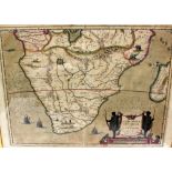
Jansson, Jan (1588-1664). Early 17th-century map of Southern Africa, featuring ships and sea monsters plus various animals, hand-coloured copper-e...
Hondius, Henricus (1597-1651).
Hondius, Henricus (1597-1651). 17th-century map of the Duchy of Holstein, featuring inset views and sailing ships, hand-coloured copper-engraving ...
Blaeu, Willem (1571-1638).
Blaeu, Willem (1571-1638). 17th-century map of Russia, featuring inset view of Moscow and figures in regional costume, hand-coloured copper engrav...
Blaeu, Joan (1596-1673).
Blaeu, Joan (1596-1673). Rare 17th-century map of Lithuania, hand-coloured copper-engraving on laid/chain-lined paper, wide margins, French text t...
Blaeu, Joan (1596-1673).
Blaeu, Joan (1596-1673). 17th-century maps of the Moscow Kremlin in Russia, a pair, hand-coloured copper-engravings on laid/chain-lined paper, wid...
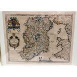
Blaeu, Willem (1571-1638).
Blaeu, Willem (1571-1638). 17th-century map of Ireland (Hibernia), hand-coloured copper-engraving on laid/chain-lined paper, Latin text to verso. ...
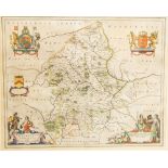
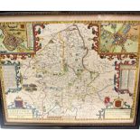
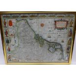
Blaeu, Joan (1596-1673).
Blaeu, Joan (1596-1673). 17th-century map of Durham, featuring coats-of-arms, figures and ships, hand-coloured copper engraving on laid/chain-line...
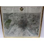
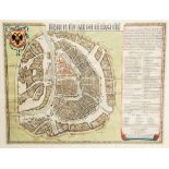
Homann, Johann Baptist (1664-1724).
Homann, Johann Baptist (1664-1724). 18th-century map/plan of Paris, hand-coloured copper-engraving on laid/chain-lined paper, circa 1739. Framed &...
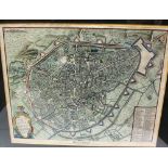
18th-century maps, a pair,
18th-century maps, a pair, showing plans of Antwerp and Brussels after the War of the Spanish Succession (1701-14), when they were transferred fro...
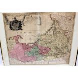
Early 18th-century map of Prussia by Peter Schenck, hand-coloured copper-engraving on laid/chain-lined paper, some discolouration and splitting at...
Bellin, Jacques-Nicolas (1703-1772). Channel Islands. 18th-century maps of Jersey and Guernsey, a pair, coper-engravings on laid/chain-lined paper...
Delisle, Guillaume (1675-1726).
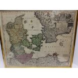
Delisle, Guillaume (1675-1726). Early 18th-century map of Scandinavia showing Denmark, Norway and Sweden, hand-coloured copper engraving on laid/c...
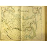
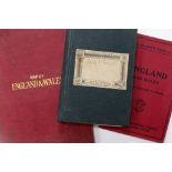
The Royal Illustrated Atlas of Modern Geography, Geographical Notice by Dr Norton Shaw, circa 1860,
The Royal Illustrated Atlas of Modern Geography, Geographical Notice by Dr Norton Shaw, circa 1860, folio, half leather. Together with Ordnance Su...
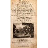
The Elements of Land Surveying, by A. Crocker, London: Longman, 1814, full calf with black morocco title label
A Selection of Views in Scotland, James Moore, London: Thomas Macklin, 1794
Travel / Exploration Interest.
Travel / Exploration Interest. History of the British Expedition to Egypt, Robert Thomas Wilson, second edition, London: T. Egerton, Military Libr...