Filtered by:
- Category
- List
- Grid
A subscription to the Price Guide is required to view results for auctions ten days or older. Click here for more information
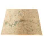

A mid 19thC James Wyld New Map of The Country Twenty Five Miles Round London, engraved and hand
A mid 19thC James Wyld New Map of The Country Twenty Five Miles Round London, engraved and hand coloured on folded cotton.
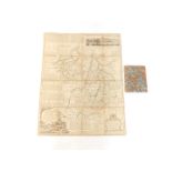
Emanuel Bowen. An accurate map of Cambridgeshire, divided into it's hundreds, hand coloured engraving, dedicated to The Right Honble Henry Clinton...
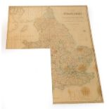
Three Victorian sectional maps of England, c1860, drawn by R Creighton, engraved by J Dower, and
Three Victorian sectional maps of England, c1860, drawn by R Creighton, engraved by J Dower, and sold by Edward Stanford., divided into Counties, ...
Victorian Ordnance Survey County and District Maps of England, including parts of Surrey, Devonshire, Rutland, The Lake District and The Chilterns...
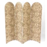
A fabric covered domed four fold screen, decorated with classical symbols and vignettes showing
A fabric covered domed four fold screen, decorated with classical symbols and vignettes showing Eighteenth Century views of Paris, 173cm H, 204cm ...