Refine your search
Sale Section
Estimate
Category
Filtered by:
- Item Type
- List
- Grid
A subscription to the Price Guide is required to view results for auctions ten days or older. Click here for more information
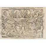
![World.- Münster (Sebastian) Typus Orbis A Ptol Descriptus, [c.1540].](https://portal-images.azureedge.net/auctions-2020/forum-10235/images/b39ac442-9f50-4af0-9ff3-ac3f00c7850c.jpg?w=155&h=155)

NO RESERVE World.- Münster (Sebastian) Typus Orbis A Ptol Descriptus, Ptolemaic map world decorated with numerous clouds and wind-heads, woodcut o...
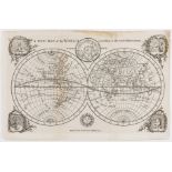
![World.- Münster (Sebastian) Typus Orbis Universalis, [c. 1550].](https://portal-images.azureedge.net/auctions-2020/forum-10235/images/9caf0064-14b1-4e6e-b0f7-ac3f00c8258b.jpg?w=155&h=155)
World.- Münster (Sebastian) Typus Orbis Universalis, map of the world presented on an oval projection surrounded by clouds and wind heads with the...
World.- Apianus (Petrus) La Cosmographia, corregida y añadida por Gemma Frisio, Anvers, Juan …
World.- Apianus (Petrus) La Cosmographia, corregida y añadida por Gemma Frisio, collation: A-Y⁴, title with large woodcut of globe, numerous woodc...
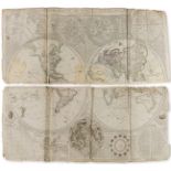
World.- A New Map of the World according to the latest Observations, engraved twin-hemisphere map showing the north and west coasts of Australia a...
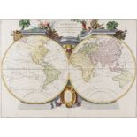
World.- Santini (Francois) and Jean Janvier. Mappe Monde ou Description du Globe Terrestre, [c. …
World.- Santini (Francois) and Jean Janvier. Mappe Monde ou Description du Globe Terrestre, double-hemisphere world map pre-dating Cook's last voy...
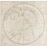
World.- South Pole.- Cook's Voyages.- , Carte de l'Hemisphere Austral Montrant les Routes des …
World.- South Pole.- Cook's Voyages.- Carte de l'Hemisphere Austral Montrant les Routes des Navigateurs les Plus Celebres par le Capitaine Jacques...
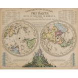
NO RESERVE World & Celestial.- Dunn (Samuel) A General Map of the World, or Terraqueous Globe, with all the New Discoveries and Marginal Delineati...
![Celestial.- Mariette (Pierre, publisher) Planisfere du Globe Celeste, [c. 1650].](https://portal-images.azureedge.net/auctions-2020/forum-10235/images/79f9478e-0616-463e-9a46-ac3f00c79169.jpg?w=155&h=155)
Celestial.- Mariette (Pierre, publisher) Planisfere du Globe Celeste, double-hemisphere celestial map, said to be from the observations of the Dan...
![Celestial.- Homann (Johann Baptist) Hemisphaerium Coeli Boreale [and] Hemisphaerium Coeli …](https://portal-images.azureedge.net/auctions-2020/forum-10235/images/551a5c5a-154d-4008-b752-ac3f00c85320.jpg?w=155&h=155)
Celestial.- Homann (Johann Baptist) Hemisphaerium Coeli Boreale [and] Hemisphaerium Coeli Australe, a pair of celestial charts with numerous vigne...
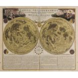
Celestial.- Homann (Johann Baptist) and Johann Gabriel Doppelmayr. Tabula Selenographica..., 1742.
Celestial.- Homann (Johann Baptist) and Johann Gabriel Doppelmayr. Tabula Selenographica, in qua Lunarium Macularum Exacta Descriptio Secundum Nom...
![Celestial.- Solar System.- Homann (Johann Baptist) Systema Solare Et Planetarium, [c. 1740].](https://portal-images.azureedge.net/auctions-2020/forum-10235/images/6a40c804-b273-490e-971b-ac3f00c80516.jpg?w=155&h=155)
NO RESERVE Celestial.- Solar System.- Homann (Johann Baptist) & Johann Gabriel Doppelmayr. Systema Solare Et Planetarium, engraving with hand-colo...
![Celestial.- Woodthorpe (Vincent) The Horizon, [c. 1801-1803].](https://portal-images.azureedge.net/auctions-2020/forum-10235/images/250cedc2-7c05-4b48-ad5f-ac3f00c760bc.jpg?w=155&h=155)
NO RESERVE Celestial.- Woodthorpe (V[incent]) The Horizon, doube-page map of the horizon from Woolsey's ' Cellestial Companion or projects in plan...
![Celestial.- Goodacre (Walter) Map of the Moon, [c. 1910].](https://portal-images.azureedge.net/auctions-2020/forum-10235/images/63a7cdcf-fbb9-49bf-8f89-ac3f00c79550.jpg?w=155&h=155)
NO RESERVE Celestial.- Goodacre (Walter) Map of the Moon, reduced map based on Goodacre's 77" diameter manuscript map of the moon, lithograph, 65...
Astronomy.- Reynolds (James, publisher) Astronomical Diagrams, 19 hand-coloured engraved diagrams of astronomical phenomena, some with tissue pape...
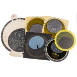
Astronomy.- A collection of six planispheres, early 20th century and slightly later; together with …
NO RESERVE Astronomy.- A collection of six planispheres, various sizes, early 20th century and slightly later; together with Richard A. Proctor's ...
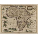
![Africa.- Ortelius (Abraham) Africae Tabula Nova, [c. 1570].](https://portal-images.azureedge.net/auctions-2020/forum-10235/images/92274723-5ff5-4204-9864-ac3f00c853d6.jpg?w=155&h=155)
Africa.- Ortelius (Abraham) Africae Tabula Nova, map of the African continent, with Madagascar and part of the Arabian Gulf, Zanzibar is shown on ...
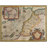
Africa.- Morocco.- Ortelius (Abraham) Fessae et Marocchi regna Africae celeberr describebat, c. …
Africa.- Morocco.- Ortelius (Abraham) Fessae et Marocchi regna Africae celeberr describebat, inset map of West-Africa based on Pigafetta's map of ...
Africa.- Hondius (Henricus) Africae Nova Tabula, detailed and decorative map of the continent from 'Atlas Novus', featuring sailing ships, flying ...
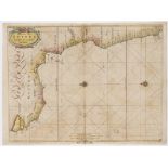
Africa.- Goos (Pieter) Pas-Caart van Guinea en den Custen daer aen gelegen van Cabo verde tot Cabo …
Africa.- Goos (Pieter) Pas-Caart van Guinea en den Custen daer aen gelegen van Cabo verde tot Cabo de Bona Esperanca, coastal chart of West Africa...
Africa.- Blome (Richard) A Mapp of the Higher and Lower Aethiopia Comprehending ye Several Kingdomes..., with elaborate heraldic cartouche and a d...
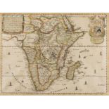
![Africa.- Speed (John) Africae, described..., [1676]](https://portal-images.azureedge.net/auctions-2020/forum-10235/images/626d2545-26f4-4ea6-bcab-ac3f00c738f6.jpg?w=155&h=155)
Africa.- Speed (John) Africae, described, the manners of their habits, and buildings, the first map of Africa prepared by an English cartographer,...
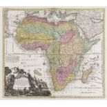
Africa.- Seutter (Matthäus) Africa Iuxta Navigationes et Observationes Recentissimas Aucta Correcta et in sua Regna et Status Divisa, map of Afric...
![South Africa.- De L'Isle (Guillaume) Carta Geografica Capo del Buona Speranza, [circa 1750]; and …](https://portal-images.azureedge.net/auctions-2020/forum-10235/images/8de71ed2-3547-4f31-b18a-ac3f00c82bf5.jpg?w=155&h=155)
South Africa.- De L'Isle (Guillaume) Carta Geografica Capo del Buona Speranza, [circa 1750]; and …
South Africa.- De L'Isle (Guillaume) Carta Geografica Capo del Buona Speranza, scarce map showing the second early expansion of the Cape of Good H...
![Algeria.- Seutter (Matthäus) Algercum munita metropolis Regni Algeriani..., [1732]](https://portal-images.azureedge.net/auctions-2020/forum-10235/images/49720dd7-8c8b-464d-949c-ac3f00c8097e.jpg?w=155&h=155)
NO RESERVE Algeria.- Seutter (Matthäus) Algercum munita metropolis Regni Algeriani..., bird's-eye plan of Algiers and its harbour, with two large ...
America.- Colonial Southern United States, Florida.- Gibson (John) A Map of the New Governments, …
NO RESERVE America.- Colonial Southern United States, Florida.- Gibson (John) A Map of the New Governments, of East & West Florida, with inset pla...
Americas.- Sayer (Robert) and John Bennett. A New Map of the Whole Continent of America, Divided …
Americas.- Sayer (Robert) and John Bennett. A New Map of the Whole Continent of America, Divided into North and South and West Indies, large-scale...
America.- West Indies.- Sayer (Robert) and John Bennett. A New and Correct Map of North America, …
America.- West Indies.- Sayer (Robert) and John Bennett. A New and Correct Map of North America, with the West India Islands. Divided According to...
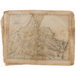
America.- Reid (John) The American Atlas, title with contents, 21 engraved maps, including the added folding plan of Washington D.C, some ink marg...
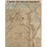
America.- Virginia.- Bacon (George W.) Bacon's New Map of the Seat of War in Virginia and Maryland, showing the interesting localities around Rich...
America.- California mining.- Orconera Iron Ore Company Ltd. Obregon Mines & Railway demarcation …
America.- California mining.- Orconera Iron Ore Company Ltd. Obregon Mines & Railway demarcation plan showing operations carried out between June ...
![Americas.- Florida.- Peru.- Ortelius (Abraham) Peruviae Auriferae Regionis Typus [on sheet with] …](https://portal-images.azureedge.net/auctions-2020/forum-10235/images/cfb825c1-4876-4a64-b878-ac3f00c793d1.jpg?w=155&h=155)
Americas.- Florida.- Peru.- Ortelius (Abraham) Peruviae Auriferae Regionis Typus [on sheet with] …
Americas.- Florida.- Peru.- Ortelius (Abraham) Peruviae Auriferae Regionis Typus [on sheet with] La Florida [and] Guastecan Reg, three maps on one...
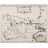
South America.- De Laet (Johannes) Venezuela ende het Westelyckste Gedeelte van Nueva Andalusia, …
NO RESERVE South America.- De Laet (Johannes) Venezuela ende het Westelyckste Gedeelte van Nueva Andalusia, map of Venezuela, with ornamental titl...
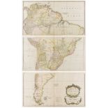
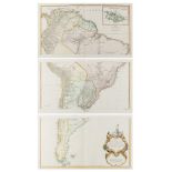
South America.- Bolton (Solomon) South America. Performed Under the Patronage of Louis Duke of …
South America.- Bolton (Solomon) South America. Performed Under the Patronage of Louis Duke of Orleans First Prince of the Blood, by the Sieur D'A...
South America.- Schraembl (Franz Anton) Karte von Sud-America Verfasst von Herrn d'Anville Geographen des Konigs von Frankreich, large and impress...
![Mexico & Texas.- Wyld (James) Republic of Mexico and Texas, [c. 1845].](https://portal-images.azureedge.net/auctions-2020/forum-10235/images/df31279f-e427-471c-80fc-ac3f00c82eb0.jpg?w=155&h=155)
Mexico & Texas.- Wyld (James) Republic of Mexico and Texas, showing Texas as separate from the United States and from Mexico, engraving with hand-...
![Asia.- Speed (John) A Newe Mape of Tartary, [1676].](https://portal-images.azureedge.net/auctions-2020/forum-10235/images/4f982a6b-67a5-4a01-988d-ac3f00c77d28.jpg?w=155&h=155)
Asia.- Speed (John) A Newe Mape of Tartary, detailed map showing from Lake Baikal through the regions of present-day Manchuria and Siberia to the ...
![Asia.- Homann (Johann Christoph) Asiae Recentissima Delineatio, [c. 1750].](https://portal-images.azureedge.net/auctions-2020/forum-10235/images/04989ae1-faa8-4286-bdf9-ac3f00c837d2.jpg?w=155&h=155)
Asia.- Homann (Johann Christoph) Asiae Recentissima Delineatio, map of Asia showing from Egypt across the Arabian Peninsula, India, China, and Jap...
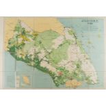
NO RESERVE Singapore & Malaysia.- Survey Dept. (Federation of Malaya) Johore, 1950, detailed map showing the topography of the region, with Singap...
Australia.- Wyld (James) Western Australia; Map of the Settlements in New South Wales; Van Diemens …
Australia.- Wyld (James) Western Australia; Map of the Settlements in New South Wales; Van Diemens Land; Islands in the Pacific Ocean, four maps, ...
![Australia.- Gold mining.- Black (Adam and Charles) Austalia [Gold districts marked], [c. 1850]; …](https://portal-images.azureedge.net/auctions-2020/forum-10235/images/fe6a6ce3-8d27-4315-920f-ac3f00c7a438.jpg?w=155&h=155)
Australia.- Gold mining.- Black (Adam and Charles) Austalia [Gold districts marked], [c. 1850]; …
Australia.- Gold mining.- Black (Adam and Charles) Austalia [Gold districts marked], engraving with hand-colouring, sheet 440 x 600 mm (17 1/4 x 2...
![Australia.- Gold mining.- Wyld (James) Gold Regions of Australia, [1854]; and four other maps on …](https://portal-images.azureedge.net/auctions-2020/forum-10235/images/106a65ab-7883-41a0-93ae-ac3f00c84c9f.jpg?w=155&h=155)
Australia.- Gold mining.- Wyld (James) Gold Regions of Australia, [1854]; and four other maps on …
Australia.- Gold mining.- Wyld (James) Gold Regions of Australia, engraving with hand-colouring, sheet 335 x 250 mm (13 1/4 x 9 7/8 in), minor sur...
Austria.- Vienna.- Homann (Johann Baptist) Prospect und Grund-Riss der Kayserl. Residenz-Stadt …
Austria.- Vienna.- Homann (Johann Baptist) Prospect und Grund-Riss der Kayserl. Residenz-Stadt Wien mit Negst Anligender Gegend und Neuen Linien u...
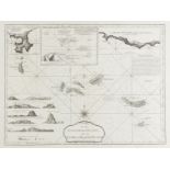
Azores.- Sayer (Robert) Chart of the Açores (Hawks) Islands, called also Flemish and Western …
Azores.- Sayer (Robert) Chart of the Açores (Hawks) Islands, called also Flemish and Western Islands, chart showing all the Azores islands with cu...
Cape Verde.- Norie (John William) A New Chart of the Cape Verde Islands..., inset maps of 'Port Praya', Porto Grande in the Islands of St Vincent'...
![China.- Blaeu (Willem Jansz.) China Veteribus Sinarum Regio nunc Incolis Tame dicta, [c. 1640]](https://portal-images.azureedge.net/auctions-2020/forum-10235/images/8e78879e-0e16-4f7a-b7b0-ac3f00c76f55.jpg?w=155&h=155)
China.- Blaeu (Willem Jansz.) China Veteribus Sinarum Regio nunc Incolis Tame dicta, [c. 1640]
China.- Blaeu (Willem Jansz.) China Veteribus Sinarum Regio nunc Incolis Tame dicta, map of Eastern China, with Japan, Korea as an island, and the...
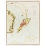
China.- Nicol (George) A Plan of the City and Harbour of Macao A Colony of the Portugueze Situated …
China.- Nicol (George) A Plan of the City and Harbour of Macao A Colony of the Portugueze Situated at the Southern Extremity of the Chinese Empire...
![Czech Republic.- Platzer (Thaddeus and Leopold) Grundriss der K. Stadt Karlsbad, [c. 1815].](https://portal-images.azureedge.net/auctions-2020/forum-10235/images/30ace36e-e3ee-415c-905d-ac3f00c77731.jpg?w=155&h=155)
Czech Republic.- Platzer (Thaddeus and Leopold) Grundriss der K. Stadt Karlsbad, plan of Karlovy Vary, engraved by Joh. Berka, with full original ...
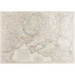
Eastern Europe.- Ottoman Empire.- Mondhare (L.J.) Carte du Théatre de la Guerre Presente Entre les …
Eastern Europe.- Ottoman Empire.- Mondhare (L.J.) Carte du Théatre de la Guerre Presente Entre les Turcs, les Russes..., showing from Poland south...
![Europe.- Münster (Sebastian) Moderna Europae Descriptio, [c. 1550]; and another (2)](https://portal-images.azureedge.net/auctions-2020/forum-10235/images/9805e704-fc35-4949-ac7a-ac3f00c7d22a.jpg?w=155&h=155)
Europe.- Münster (Sebastian) Moderna Europae Descriptio, map of Europe with north oriented to the south, showing part of the British Isles in the ...
![Europe.- Visscher (Nicolas) Europa delineata et recens edita..., [c. 1677].](https://portal-images.azureedge.net/auctions-2020/forum-10235/images/a4898b6d-9673-4603-ab75-ac3f00c847a2.jpg?w=155&h=155)
Europe.- Visscher (Nicolas) Europa delineata et recens edita..., engraved map with early hand-colouring, on laid paper, platemark 440 x 560 mm (17...
![France.- Münster (Sebastian) Gallia IIII Nova Tabula, [c. 1540].](https://portal-images.azureedge.net/auctions-2020/forum-10235/images/1d56f334-a109-4353-827c-ac3f00c831d1.jpg?w=155&h=155)
France.- Munster (Sebastian) Gallia IIII Nova Tabula, woodcut map, the place names both Ptolemaic and modern, sheet 310 x 400 mm (12 1/4 x 15 3/4 ...
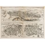
France.- Braun (Georg) and Franz Hogenberg. Rotomagus, Vulgo Roan - Nemausus, Nismes - Civitatis …
France.- Braun (Georg) and Franz Hogenberg. Rotomagus, Vulgo Roan - Nemausus, Nismes - Civitatis Burdegalensis, three bird's-eye views on one plat...
![France.- Braun (Georg) and Franz Hogenberg. Lugdunum, [c. 1572].](https://portal-images.azureedge.net/auctions-2020/forum-10235/images/001a5169-0027-4dfb-93ad-ac3f00c83569.jpg?w=155&h=155)
France.- Braun (Georg) and Franz Hogenberg. Lugdunum, engraved plan of Lyons, 330 x 490 mm (13 x 19 1/4 in), slight wear to centre fold verso with...
![France.- Baur (Johann Wilhelm) [Siege of Valenciennes, then in the Hapsburg Netherlands], 1632.](https://portal-images.azureedge.net/auctions-2020/forum-10235/images/907e9801-dde1-4263-b628-ac3f00c82676.jpg?w=155&h=155)
France.- Baur (Johann Wilhelm) [Siege of Valenciennes, then in the Hapsburg Netherlands], 1632.
France.- Baur (Johann Wilhelm, 1607-1641) [Siege of Valenciennes, then in the Hapsburg Netherlands], etching, 295 x 415 mm (11 3/4 x 16 1/4 in), l...
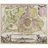
![France.- Homann (Johann Baptist) Comitatus Burgundiae, [c. 1730].](https://portal-images.azureedge.net/auctions-2020/forum-10235/images/d66859ba-385b-4cf3-b2c3-ac3f00c82dc9.jpg?w=155&h=155)
France.- Homann (Johann Baptiste) Comitatus Burgundiae, engraved map of Burgundy with original hand-colouring, 580 x 490 mm (22 3/4 x 19 1/4 in), ...
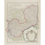
France.- Bonne (Rigobert) A group of regional maps including Normandy, Brittany, Champagne, Isle …
France.- Bonne (Rigobert) A group of regional maps including Normandy, Brittany, Champagne, Isle de France, Gascony and Languedoc, 14 engraved map...
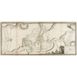
![France.- Anonymous. Manuscript map chart of the Pointe du Raz, Brittany, [c. 1799]; and another (2)](https://portal-images.azureedge.net/auctions-2020/forum-10235/images/d49c95e3-84cb-4ef1-a2a9-ac3f00c82b0c.jpg?w=155&h=155)
France.- Anonymous. Manuscript map chart of the Pointe du Raz, Brittany, [c. 1799]; and another (2)
NO RESERVE France.- Anonymous. Manuscript map chart of the Pointe du Raz, Brittany, pen and ink map over pencil, on laid paper with watermark date...
France.- Beaulieu (Sébastien Pontault de) 21 plates from 'Les glorieuses Conquêtes de Louis-le-Grand, Roy de France, et de Navarre', including a f...
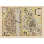
![France.- Lorrain.- Braun (Georg) and Franz Hogenberg. Metz, c. 1575 [or slightly later]; and …](https://portal-images.azureedge.net/auctions-2020/forum-10235/images/dc34b5de-5e54-4123-b5f7-ac3f00c83c7d.jpg?w=155&h=155)
France.- Lorrain.- Braun (Georg) and Franz Hogenberg. Metz, c. 1575 [or slightly later]; and …
NO RESERVE France.- Lorrain.- Braun (Georg) and Franz Hogenberg. Metz, bird's-eye view of Metz showing the fortified city surrounded by the Seille...
France.- Fourteen maps including Braun & Hogenberg's plans of Macon and Chalons, 17th and 18th …
France.- A group of maps including Braun & Hogenberg's plans of Macon and Chalons, engraving with hand-colouring, c. 1617; F.de Witt's Generalis L...