Filtered by:
- Sale Section
- List
- Grid
A subscription to the Price Guide is required to view results for auctions ten days or older. Click here for more information
![World.- Münster (Sebastian) Altera Generalis Tab. Secundum Ptol., [c. 1545-50].](https://portal-images.azureedge.net/auctions-2019/forum-10180/images/c78c6b61-292f-42ca-8235-aaa300f1da3d.jpg?w=155&h=155)

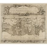
Ancient World.- Münster (Sebastian) Altera Generalis Tab. Secundum Ptol., clouds and eight named wind heads surround a map illustrating the concep...
World.- Zahn (Johannes) Tabula Geographico-Hydrographica Motus Oceani Currentes, Abyssos, Montes …
World.- Zahn (Johannes) Tabula Geographico-Hydrographica Motus Oceani Currentes, Abyssos, Montes Igniuomos in Universo, an unusual example of earl...
![World.- [Briet (Philippe)] Orbis Pars Veteribus Cognita, [circa 1640s]; together with 12 …](https://portal-images.azureedge.net/auctions-2019/forum-10180/images/2909f5ef-db9c-4b81-885b-aaa300f21933.jpg?w=155&h=155)
NO RESERVE World.- [Briet (Philippe)] Orbis Pars Veteribus Cognita, engraving, 160 x 260 mm. (6 1/4 x 10 1/4 in), folds as issued some handling cr...
![World.- Stoopendaal (Daniel) Werelt Caert, [1688].](https://portal-images.azureedge.net/auctions-2019/forum-10180/images/67012e47-b93b-4e16-8035-aaa300f179db.jpg?w=155&h=155)
World.- Stoopendaal (Daniel) Werelt Caert, double-hemisphere world map from a Dutch bible is based on Visscher's similar map of 1663, showing Cali...
![Africa.- Ortelius (Abraham) Africae Tabula Nova [1570 or later]](https://portal-images.azureedge.net/auctions-2019/forum-10180/images/f9014249-33a9-40cd-9ddc-aaa300f1f59a.jpg?w=155&h=155)
Africa.- Ortelius (Abraham) Africae Tabula Nova, map of the African continent, with Madagascar and part of the Arabian Gulf, Zanzibar is shown on ...
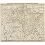
Africa.- Münster (Sebastian) Africa Libya Morland mit Allen Kunigreichen so zu Unsern Zeiten darin …
Africa.- Münster (Sebastian) Africa Libya Morland mit Allen Kunigreichen so zu Unsern Zeiten darin Gefunden Werden, map of the continent based on ...
Africa.- Speed (John) Africae, described the manners of their habits, and buildings, the first map of Africa prepared by an English cartographer, ...
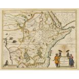
Africa.- Jansson (Jan) Aethiopia Superior vel Interior; Vulgo Abissinorum sive Presbiteri Ioannis …
Africa.- Jansson (Jan) Aethiopia Superior vel Interior; Vulgo Abissinorum sive Presbiteri Ioannis Imperium, map showing the legendary Christian Ki...
![Africa.- Barbary pirates.- Blaeu (Johannes) Barbaria, [c. 1650].](https://portal-images.azureedge.net/auctions-2019/forum-10180/images/36fe027a-074d-4937-b42d-aaa300f16a91.jpg?w=155&h=155)
Africa.- Barbary pirates.- Blaeu (Johannes) Barbaria, two maps of the Mediterranean coast of Africa, the top map showing the entire coast from C. ...
![Africa.- Jansson (Jan) Guinea, [c. 1650].](https://portal-images.azureedge.net/auctions-2019/forum-10180/images/f7d70589-6f94-4a7b-abfd-aaa300f1869d.jpg?w=155&h=155)
Africa.- Jansson (Jan) Guinea, highly decorative map illustrating the coast from Sierra Leone to Gabon, the land filed with lions, elephants, and ...
Africa.- Fer (Nicholas de) Partie Occidentale de l'Afrique ou se Trouve la Barbarie Divisee en …
Africa.- Fer (Nicholas de) Partie Occidentale de l'Afrique ou se Trouve la Barbarie Divisee en Royaumes, map of the northwestern portion of Africa...
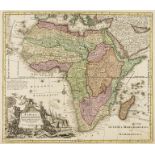
Africa.- Seutter (Matthäus) Africa Iuxta Navigationes et Observationes Recentissimas Aucta Correcta et in sua Regna et Status Divisa, in Lucem Edi...
![Africa.- De L'Isle (Guillaume) Carte de la Barbarie de la Nigritie et de la Guinée, [c. 1730].](https://portal-images.azureedge.net/auctions-2019/forum-10180/images/f0c5325c-27cf-42a7-aaa8-aaa300f171e9.jpg?w=155&h=155)
Africa.- De L'Isle (Guillaume) Carte de la Barbarie de la Nigritie et de la Guinée, [c. 1730].
Africa.- De L'Isle (Guillaume) Carte de la Barbarie de la Nigritie et de la Guinée, map of western Africa from Barbary, Nigeria, and Guinea to bel...
![Africa.- Lizars (Daniel) Africa, [c. 1820].](https://portal-images.azureedge.net/auctions-2019/forum-10180/images/c83ab34d-2816-4cc9-bba0-aaa300f1b2d3.jpg?w=155&h=155)
Africa.- Lizars (Daniel) Africa, map of Southern Africa, showing from Gabon to South Africa, including Madagascar and outlying islands, engraving ...
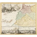
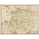
Africa.- Morocco.- Homann (Johann Christoph) Statuum Marocca Norum, Regnorum Nempe Fessani, …
Africa.- Morocco.- Homann (Johann Christoph) Statuum Marocca Norum, Regnorum Nempe Fessani, Maroccani, Tafiletani et Segelomessani, decorative map...
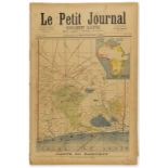
Africa.- French colonial empire.- Petit Journal (Le) Carte Du Dahomey, supplement issue with map of present day Benin on cover and inset map of Af...
![Africa.- Silk map.- Anonymous. Somaliland [recto]; Kenya Colony & Juba River [verso], double-sided …](https://portal-images.azureedge.net/auctions-2019/forum-10180/images/2f93e310-e203-4ecc-8345-aaa300f20854.jpg?w=155&h=155)
Africa.- Silk map.- Anonymous. Somaliland [recto]; Kenya Colony & Juba River [verso], double-sided …
NO RESERVE Africa.- Silk map.- Anonymous. Somaliland [recto]; Kenya Colony & Juba River [verso], double-sided military map, lithograph printed on ...
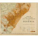
Africa.- Military maps.- Survey Dept. (Lagos, Nigeria) Map of the Colony and Protectorate of …
Africa.- Military maps.- Survey Dept. (Lagos, Nigeria) Map of the Colony and Protectorate of Nigeria, four sheet map, unjoined, lithographs printe...
![Africa.- Military maps.- Militair Geografisch Instituut. Brussel. Belgisch Congo, [c. 1930-1950] (4)](https://portal-images.azureedge.net/auctions-2019/forum-10180/images/f7e268d6-5a60-4f4b-8c21-aaa300f1e1aa.jpg?w=155&h=155)
Africa.- Military maps.- Militair Geografisch Instituut. Brussel. Belgisch Congo, [c. 1930-1950] (4)
Africa.- Military maps.- Militair Geografisch Instituut. Brussel. Belgisch Congo, large-scale four sheet map, lithographs printed in colour, each ...
![South Africa.- Jansson (Jan) Aethiopia Inferior, vel Exterior, [c. 1640].](https://portal-images.azureedge.net/auctions-2019/forum-10180/images/6239ed94-d6c1-4393-a8b7-aaa300f1f0b0.jpg?w=155&h=155)
South Africa.- Jansson (Jan) Aethiopia Inferior, vel Exterior, map of South Africa covering the region from Congo-Zanzibar to the Cape, decorative...
South Africa.- Delarochette (Louis Stanislas d'Arcy) Das Vorgebirg der Guten Hofnung, map of the southwestern tip of Africa, showing from the 'Kli...
Pacific Ocean.- Ortelius (Abraham) Maris Pacifici, (quod vulgo Mar del Zur), the first printed map devoted to the Pacific and the first to label t...
Pacific Ocean and Indian Ocean Islands.- Cassini (Giovanni Maria) Le Isole della Societa e di Noel …
Pacific Ocean and Indian Ocean Islands.- Cassini (Giovanni Maria) Le Isole della Societa e di Noel Delineate sulle Ultime Osservazioni del Capitan...
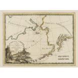
Pacific Ocean.- The Bering Strait.- Cassini (Giovanni Maria) Le Coste Nord Ovest dell'America e …
Pacific Ocean.- The Bering Strait.- Cassini (Giovanni Maria) Le Coste Nord Ovest dell'America e Nord Est dell'Asia Delineate sulle ultime Osservaz...
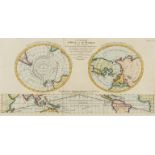
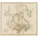
Polar.- Captain Cook.- Bell (Andrew) Geography A Map of the World in Three Sections, Describing …
Polar.- Captain Cook.- Bell (Andrew) Geography A Map of the World in Three Sections, Describing the Polar Regions to the Tropics In Which Are Trac...
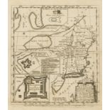
Americas.- Blaeu ( Willem Jansz.) Virginiae Partis Australis, et Floridae Partis Orientalis, …
Americas.- Blaeu (Willem Jansz.) Virginiae Partis Australis, et Floridae Partis Orientalis, Interjacentiumq Regionum Nova Descriptio, map of the S...
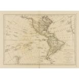
Americas.- Dunn (Samuel) America North and South; with the Atlantic and Pacific Oceans; wherein …
Americas.- Dunn (Samuel) America North and South; with the Atlantic and Pacific Oceans; wherein are distinguished all the New Discoveries, map of ...
Americas.- Zatta (Antonio) Il Canada, le Colonie Inglesi con la Luigiana, e Florida di Nuova …
Americas.- Zatta (Antonio) Il Canada, le Colonie Inglesi con la Luigiana, e Florida di Nuova Projezione, Revolutionary War map illustrating all of...
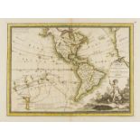
Americas.- Cassini (Giovanni Maria) L'America Secondo le Ultime Osservazioni Divisa ne suoi Stati …
Americas.- Cassini (Giovanni Maria) L'America Secondo le Ultime Osservazioni Divisa ne suoi Stati Principali, map showing from New Zealand, the Pa...
Americas.- Cooke (Charles) A New & Accurate Map of North America including Nootka Sound: with the …
Americas.- Cooke (Charles) A New & Accurate Map of North America including Nootka Sound: with the new discovered Islands on the North East coast o...
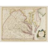
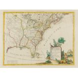
Americas.- Vaugondy (Gilles Robert de) Carte de la Virginie et du Maryland Dressee sur la Grande …
Americas.- Vaugondy (Gilles Robert de) Carte de la Virginie et du Maryland Dressée sur la Grande Carte Angloise de Mrs. Josué Fry et Pierre Jeffer...
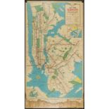
Americas.- New York.- Hagstrom Company Inc. Hagstrom's Map of New York Subways elevated lines, [c. …
Americas.- New York.- Hagstrom Company Inc. Hagstrom's Map of New York Subways elevated lines, service information for the IRT, BMT, and IND lines...
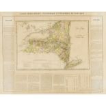
Americas.- New York.- Buchon (Jean Alexandre) Carte Geographique, Statistique et Historique du …
Americas.- New York.- Buchon (Jean Alexandre) Carte Geographique, Statistique et Historique du New-York, map of New York from the French edition o...
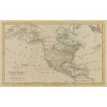
![Americas.- Spanish America.- Hermanos (Astort) América del Norte, [1876].](https://portal-images.azureedge.net/auctions-2019/forum-10180/images/5c5d9b26-bcd3-4ffd-8db4-aaa300f16dab.jpg?w=155&h=155)
Americas.- Spanish America.- Hermanos (Astort, publishers) América del Norte, detailed map of North America with surround text description in Span...
![Americas.- South America.- Blaeu (Willem Jansz.) Guiana sive Amazonum Regio, [c. 1640].](https://portal-images.azureedge.net/auctions-2019/forum-10180/images/ea061e50-6822-4c47-884d-aaa300f228db.jpg?w=155&h=155)
Americas.- South America.- Blaeu (Willem Jansz.) Guiana sive Amazonum Regio, map extending from the Isla Margarita in the northwest to the coast o...
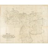
Americas.- South America.- Dalton (Leonard V.) Map of The United States of Venezuela, 1923; …
NO RESERVE Americas.- South America.- [Dalton (Leonard V.)] Map of The United States of Venezuela, including the results of the latest surveys, li...
Falkland Islands.- House of Commons (The) Copies or Extracts of any correspondence relative to the …
Falkland Islands.- House of Commons (The) Copies or Extracts of any correspondence relative to the Falkland Islands, since the last Papers laid be...
NO RESERVE Americas. Canada.- Robinson (G.G. & J.) British America, Comprehending Canada, Labrador, New-Foundland, Nova Scotia &c., engraving with...
Canada.- Jaillot (Alexis-Hubert) Le Canada ou Partie de la Nouvelle France dans l'Amerique Septentrionale, Contenant la Terre de Labrador, la Nouv...
Canada.- Colonial New England.- Owen (W.) A Map of New England & ye Country Adjacent, Extending …
NO RESERVE Canada.- Colonial New England.- Owen (W.) A Map of New England & ye Country Adjacent, Extending Northward to Quebec & Westward to Niaga...
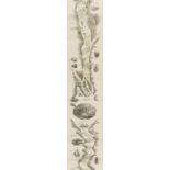
Canada.- Hunter, Jr. (William S.) Hunter's Panoramic Guide from Niagara Falls to Quebec, 1857; …
Canada.- Hunter, Jr. (William S.) Hunter's Panoramic Guide from Niagara Falls to Quebec, engraved pictorial title, large folding panorama engraved...
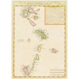
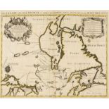
Caribbean.- French Antilles.- Chatelain (Henri Abraham) Carte Des Antilles Francoises et des Isles …
Caribbean.- French Antilles.- Chatelain (Henri Abraham) Carte Des Antilles Francoises et des Isles Voisines dressee sur des memoires manuscrits, s...
Caribbean.- Battle of St. Lucia.- Faden (William) Sketch of Part of the Island of Ste. Lucie, 1781.
Caribbean.- Battle of St. Lucia.- Faden (William) Sketch of Part of the Island of Ste. Lucie, map by Lt. G.V. Hart, assistant engineer while in No...
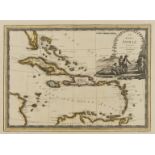
Caribbean.- Cassini (Giovanni Maria) Le Isole Antille Delineate Sulle Ultime Osservazioni, 1798.
Caribbean.- Cassini (Giovanni Maria) Le Isole Antille Delineate Sulle Ultime Osservazioni, map of the Caribbean and southern tip of Florida, showi...
![Caribbean.- Stockdale (John) A Map of the Island of St. Domingo, [1806].](https://portal-images.azureedge.net/auctions-2019/forum-10180/images/8270cbee-2ec3-418e-b779-aaa300f175cf.jpg?w=155&h=155)
Caribbean.- Stockdale (John) A Map of the Island of St. Domingo, detailed map of Hispaniola, Saint Domingue or present-day Haiti and Dominican Rep...
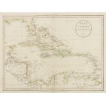
Caribbean.- Russell (John) West Indies Drawn from the Best Authorities, showing part of southern Florida, across Cuba, S. Domingo, to Trinidad, wi...
![Caribbean.- Thomson (John) Jamaica, [1817].](https://portal-images.azureedge.net/auctions-2019/forum-10180/images/f1f9624e-308c-4a2e-b221-aaa300f22a37.jpg?w=155&h=155)
Caribbean.- Thomson (John) Jamaica, map of the island, with insets of the Harbour of Bluefields, and The Harbours of Kingston & Port Royal, from T...
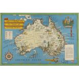
Australia.- Gill (Leslie MacDonald) Australia. Her Natural and Industrial Resources, pictorial wartime map of Australia illustrating the Commonwea...
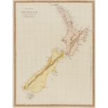
New Zealand.- SDUK (Society for the Diffusion of Useful Knowledge) The Islands of New Zealand, 1838.
New Zealand.- SDUK (Society for the Diffusion of Useful Knowledge) The Islands of New Zealand, decorative map showing north and south islands, eng...
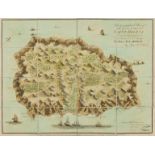
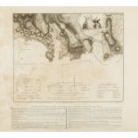
Saint Helena.- Read (Lieut. R.P.) Geographical Plan of The Island & Forts of Saint Helena, 1815.
Saint Helena.- Read (Lieut. R.P.) Geographical Plan of The Island & Forts of Saint Helena, the island orientated with north to the lower left corn...
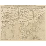
Asia.- Münster (Sebastian) Tabula Orientalis Regionis, Asiae Scilicet Extremas Complectens Terras …
Asia.- Münster (Sebastian) Tabula Orientalis Regionis, Asiae Scilicet Extremas Complectens Terras & Regna, one of the earliest maps of the whole c...
![Asia.- Münster (Sebastian) Tabula Asiae VII, [c. 1550]](https://portal-images.azureedge.net/auctions-2019/forum-10180/images/b01979a3-8b9f-48aa-98a1-aaa300f1749c.jpg?w=155&h=155)
Asia.- Münster (Sebastian) Tabula Asiae VII, Ptolemaic map of the region east of the Caspian Sea including present-day Kazakhstan, Uzbekistan, Tur...
![Asia.- Magini (Giovanni Antonio) Tabula Asiae II, [1597].](https://portal-images.azureedge.net/auctions-2019/forum-10180/images/ea7f7159-ac7e-4a31-b060-aaa300f1c2c7.jpg?w=155&h=155)
Asia.- Magini (Giovanni Antonio) Tabula Asiae II, Ptolemaic map presented on a trapezoidal projection, showing the Caucasus region from modern-day...
![Asia.- Silk Road.- Ruscelli (Girolamo) Tabula Asie II, [c. 1574].](https://portal-images.azureedge.net/auctions-2019/forum-10180/images/2f9aaaa1-ba1c-42f1-8e12-aaa300f22e5b.jpg?w=155&h=155)
Asia.- Silk Road.- Ruscelli (Girolamo) Tabula Asie II, Ptolemaic map presented on a trapezoidal projection, showing the Caucasus region from moder...
![Asia.- Southeast Asia.- Mercator (Gerard) Asiae XI Tab:, [circa 1595].](https://portal-images.azureedge.net/auctions-2019/forum-10180/images/50990ce9-0813-4e7a-b05f-aaa300f199d8.jpg?w=155&h=155)
Asia.- Southeast Asia.- Mercator (Gerard) Asiae XI Tab: [Asiae Tabula XI], map illustrating the Ptolemaic concept of Malaya and Indochina, or "Ind...
![Southeast Asia.- Spice Islands.- Jansson (Jan) Insularum Moluccarum Nova Descriptio, [circa 1640].](https://portal-images.azureedge.net/auctions-2019/forum-10180/images/b7c5d577-3efa-4356-9e4d-aaa300f204ef.jpg?w=155&h=155)
Southeast Asia.- Spice Islands.- Jansson (Jan) Insularum Moluccarum Nova Descriptio, [circa 1640].
Asia.- Southeast Asia.- Spice Islands.- Jansson (Jan) Insularum Moluccarum Nova Descriptio, map of the Spice Islands, the cornerstone of the Dutch...
![Asia.- Pakistan, Afghanistan & Western India.- Mercator (Gerard) Asiae IX Tab:, [c. 1697].](https://portal-images.azureedge.net/auctions-2019/forum-10180/images/8e0097ef-6701-4f45-b274-aaa300f22457.jpg?w=155&h=155)
Asia.- Pakistan, Afghanistan & Western India.- Mercator (Gerard) Asiae IX Tab:, Ptolemaic map of Central Asia, centered on the Indus River, decora...
![Asia.- Seutter (Matthäus) Asia cum omnibus Imperiis, Provinciis, Statibus et Insulis..., [c. 1730].](https://portal-images.azureedge.net/auctions-2019/forum-10180/images/b00feb5e-af4e-4b3f-bc64-aaa300f1a420.jpg?w=155&h=155)
Asia.- Seutter (Matthäus) Asia cum omnibus Imperiis, Provinciis, Statibus et Insulis..., [c. 1730].
Asia.- Seutter (Matthäus) Asia cum omnibus Imperiis, Provinciis, Statibus et Insulis..., map of Asia, showing eastern Europe, Scandinavia, Egypt a...
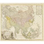
Asia.- Homann Heirs. Asia Secundum Legitimas Projectionis Stereographicae Regulas et Juxta Recentissimas Observationes..., detailed map of Asia, s...
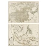
Asia.- d'Anville (Jean Baptiste Bourguignon) Seconde Partie de la Carte d'Asie Contenant la Chine …
Asia.- d'Anville (Jean Baptiste Bourguignon) Seconde Partie de la Carte d'Asie Contenant la Chine et Partie de la Tartarie, l'Inde au dela du Gang...